Plougasnou
| Plougasnou Plouganoù | ||
|---|---|---|
| Commune | ||
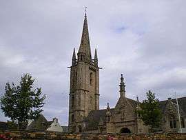 The church of Saint-Pierre, in Plougasnou | ||
| ||
 Plougasnou Location within Brittany region  Plougasnou | ||
| Coordinates: 48°41′47″N 3°47′17″W / 48.6964°N 3.7881°WCoordinates: 48°41′47″N 3°47′17″W / 48.6964°N 3.7881°W | ||
| Country | France | |
| Region | Brittany | |
| Department | Finistère | |
| Arrondissement | Morlaix | |
| Canton | Plouigneau | |
| Intercommunality | Morlaix | |
| Government | ||
| • Mayor (2014–2020) | Nathalie Bernard | |
| Area1 | 33.94 km2 (13.10 sq mi) | |
| Population (2013)2 | 3,108 | |
| • Density | 92/km2 (240/sq mi) | |
| Time zone | UTC+1 (CET) | |
| • Summer (DST) | UTC+2 (CEST) | |
| INSEE/Postal code | 29188 /29630 | |
| Elevation | 0–94 m (0–308 ft) | |
|
1 French Land Register data, which excludes lakes, ponds, glaciers > 1 km2 (0.386 sq mi or 247 acres) and river estuaries. 2 Population without double counting: residents of multiple communes (e.g., students and military personnel) only counted once. | ||
.svg.png)
Plougasnou (Breton: Plouganoù) is a commune in the Finistère department in Brittany in northwestern France, located about 75 kilometres east of Brest. Plougasnou is northeast of the town of Plouezoc'h, north of Lanmeur and west of Saint-Jean-du-Doigt. It had a population of 3,197 inhabitants in 2016. Inhabitants of Plougasnou are called Plouganistes.
Population
| Year | 1793 | 1800 | 1806 | 1821 | 1831 | 1836 | 1841 | 1846 | 1851 | 1856 |
|---|---|---|---|---|---|---|---|---|---|---|
| Population | 4959 | 3103 | 3106 | 3029 | 3827 | 3790 | 3817 | 4003 | 3735 | 3650 |
| Year | 1861 | 1866 | 1872 | 1876 | 1881 | 1886 | 1891 | 1896 | 1901 | 1906 |
|---|---|---|---|---|---|---|---|---|---|---|
| Population | 3261 | 3868 | 3876 | 3786 | 3723 | 3709 | 3805 | 3644 | 3700 | 3843 |
| Year | 1911 | 1921 | 1926 | 1931 | 1936 | 1946 | 1954 | 1962 | 1968 | 1975 |
|---|---|---|---|---|---|---|---|---|---|---|
| Population | 3997 | 3968 | 3767 | 3677 | 3687 | 3683 | 3350 | 3536 | 3422 | 3368 |
| Year | 1990 | 1999 | 2008 |
|---|---|---|---|
| Population | 3530 | 3393 | 3231 |
See also
References
- Mayors of Finistère Association (in French)
External links
| Wikimedia Commons has media related to Plougasnou. |
- Official website (in French)
- French Ministry of Culture list for Plougasnou (in French)
| Authority control |
|---|
This article is issued from
Wikipedia.
The text is licensed under Creative Commons - Attribution - Sharealike.
Additional terms may apply for the media files.