Guiclan
| Guiclan Gwiglann | ||
|---|---|---|
| Commune | ||
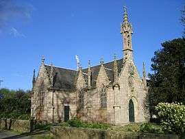 The Chapel of Saint-Jacques, in Guiclan | ||
| ||
 Guiclan Location within Brittany region  Guiclan | ||
| Coordinates: 48°33′07″N 3°57′37″W / 48.5519°N 3.9603°WCoordinates: 48°33′07″N 3°57′37″W / 48.5519°N 3.9603°W | ||
| Country | France | |
| Region | Brittany | |
| Department | Finistère | |
| Arrondissement | Morlaix | |
| Canton | Landivisiau | |
| Intercommunality | Pays de Landivisiau | |
| Government | ||
| • Mayor (2014–2020) | Raymond Mercier | |
| Area1 | 42.64 km2 (16.46 sq mi) | |
| Population (2008)2 | 2,143 | |
| • Density | 50/km2 (130/sq mi) | |
| Time zone | UTC+1 (CET) | |
| • Summer (DST) | UTC+2 (CEST) | |
| INSEE/Postal code | 29068 /29410 | |
| Elevation | 3–131 m (9.8–429.8 ft) | |
|
1 French Land Register data, which excludes lakes, ponds, glaciers > 1 km2 (0.386 sq mi or 247 acres) and river estuaries. 2 Population without double counting: residents of multiple communes (e.g., students and military personnel) only counted once. | ||
.svg.png)
Guiclan (Breton: Gwiglann) is a commune in the Finistère department of Brittany in north-western France.
Population
Inhabitants of Guiclan are called in French Guiclanais.
| Year | 1962 | 1968 | 1975 | 1982 | 1990 | 1999 | 2008 |
|---|---|---|---|---|---|---|---|
| Population | 2202 | 2076 | 2011 | 1937 | 2045 | 2030 | 2143 |
See also
References
- Mayors of Finistère Association (in French);
External links
| Wikimedia Commons has media related to Guiclan. |
- Official website (in French)
- French Ministry of Culture list for Guiclan (in French)
This article is issued from
Wikipedia.
The text is licensed under Creative Commons - Attribution - Sharealike.
Additional terms may apply for the media files.