Bourg-Blanc
| Bourg-Blanc Ar Vourc'h-Wenn | ||
|---|---|---|
| Commune | ||
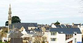 A general view of Bourg-Blanc | ||
| ||
 Bourg-Blanc Location within Brittany region  Bourg-Blanc | ||
| Coordinates: 48°30′01″N 4°30′13″W / 48.5003°N 4.5036°WCoordinates: 48°30′01″N 4°30′13″W / 48.5003°N 4.5036°W | ||
| Country | France | |
| Region | Brittany | |
| Department | Finistère | |
| Arrondissement | Brest | |
| Canton | Plabennec | |
| Intercommunality | Plabennec et des Abers | |
| Government | ||
| • Mayor (2014–2020) | Bernard Gibergues | |
| Area1 | 28.31 km2 (10.93 sq mi) | |
| Population (2008)2 | 3,268 | |
| • Density | 120/km2 (300/sq mi) | |
| Time zone | UTC+1 (CET) | |
| • Summer (DST) | UTC+2 (CEST) | |
| INSEE/Postal code | 29015 /29860 | |
| Elevation | 25–98 m (82–322 ft) | |
|
1 French Land Register data, which excludes lakes, ponds, glaciers > 1 km2 (0.386 sq mi or 247 acres) and river estuaries. 2 Population without double counting: residents of multiple communes (e.g., students and military personnel) only counted once. | ||
.svg.png)
Bourg-Blanc (Breton: Ar Vourc'h-Wenn) is a commune in the Finistère department of Brittany in north-western France.
Population
Inhabitants of Bourg-Blanc are called Blanc-Bourgeois in French.
| Historical population | ||
|---|---|---|
| Year | Pop. | ±% |
| 1793 | 1,444 | — |
| 1800 | 1,561 | +8.1% |
| 1806 | 1,617 | +3.6% |
| 1821 | 1,746 | +8.0% |
| 1831 | 1,729 | −1.0% |
| 1836 | 1,768 | +2.3% |
| 1841 | 1,831 | +3.6% |
| 1846 | 1,841 | +0.5% |
| 1851 | 1,920 | +4.3% |
| 1856 | 1,867 | −2.8% |
| 1861 | 1,848 | −1.0% |
| 1866 | 1,824 | −1.3% |
| 1872 | 1,761 | −3.5% |
| 1876 | 1,808 | +2.7% |
| 1881 | 1,826 | +1.0% |
| 1886 | 1,767 | −3.2% |
| 1891 | 1,708 | −3.3% |
| 1896 | 1,666 | −2.5% |
| 1901 | 1,684 | +1.1% |
| 1906 | 1,712 | +1.7% |
| 1911 | 1,762 | +2.9% |
| 1921 | 1,610 | −8.6% |
| 1926 | 1,593 | −1.1% |
| 1931 | 1,626 | +2.1% |
| 1936 | 1,651 | +1.5% |
| 1946 | 1,699 | +2.9% |
| 1954 | 1,675 | −1.4% |
| 1962 | 1,682 | +0.4% |
| 1968 | 1,784 | +6.1% |
| 1975 | 2,290 | +28.4% |
| 1982 | 2,659 | +16.1% |
| 1990 | 2,971 | +11.7% |
| 1999 | 3,077 | +3.6% |
| 2008 | 3,268 | +6.2% |
See also
References
- Mayors of Finistère Association (in French);
External links
| Wikimedia Commons has media related to Bourg-Blanc. |
- Official website (in French)
- French Ministry of Culture list for Bourg-Blanc (in French)
| Authority control |
|---|
This article is issued from
Wikipedia.
The text is licensed under Creative Commons - Attribution - Sharealike.
Additional terms may apply for the media files.