Scrignac
| Scrignac Skrigneg | |
|---|---|
| Commune | |
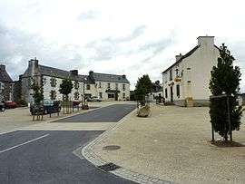 The main square in Scrignac, in 2010 | |
 Scrignac Location within Brittany region  Scrignac | |
| Coordinates: 48°26′01″N 3°40′34″W / 48.4336°N 3.6761°WCoordinates: 48°26′01″N 3°40′34″W / 48.4336°N 3.6761°W | |
| Country | France |
| Region | Brittany |
| Department | Finistère |
| Arrondissement | Châteaulin |
| Canton | Carhaix-Plouguer |
| Intercommunality | Monts d'Arrée |
| Government | |
| • Mayor (2014–2020) | Georges Morvan |
| Area1 | 70.94 km2 (27.39 sq mi) |
| Population (2008)2 | 809 |
| • Density | 11/km2 (30/sq mi) |
| Time zone | UTC+1 (CET) |
| • Summer (DST) | UTC+2 (CEST) |
| INSEE/Postal code | 29275 /29640 |
| Elevation | 86–281 m (282–922 ft) |
|
1 French Land Register data, which excludes lakes, ponds, glaciers > 1 km2 (0.386 sq mi or 247 acres) and river estuaries. 2 Population without double counting: residents of multiple communes (e.g., students and military personnel) only counted once. | |
Scrignac (Breton: Skrigneg) is a commune in the Finistère department of Brittany in north-western France.
Population
Inhabitants of Scrignac are called in French Scrignacois.
.jpg)
A marriage celebration with 2100 people at Scrignac in 1912
| Year | 1793 | 1800 | 1806 | 1821 | 1831 | 1836 | 1841 | 1846 | 1851 | 1856 |
|---|---|---|---|---|---|---|---|---|---|---|
| Population | 2016 | 2048 | 2190 | 2164 | 2586 | 2652 | 2767 | 2891 | 2890 | 2812 |
| Year | 1861 | 1866 | 1872 | 1876 | 1881 | 1886 | 1891 | 1896 | 1901 | 1906 |
|---|---|---|---|---|---|---|---|---|---|---|
| Population | 2947 | 3103 | 3056 | 3130 | 3085 | 3120 | 3140 | 3256 | 3651 | 3825 |
| Year | 1911 | 1921 | 1926 | 1931 | 1936 | 1946 | 1954 | 1962 | 1968 | 1975 |
|---|---|---|---|---|---|---|---|---|---|---|
| Population | 3832 | 3511 | 3386 | 3208 | 2869 | 2558 | 2111 | 1946 | 1687 | 1405 |
| Year | 1982 | 1990 | 1999 | 2008 |
|---|---|---|---|---|
| Population | 1222 | 1005 | 883 | 809 |
See also
References
- Mayors of Finistère Association (in French)
External links
| Wikimedia Commons has media related to Scrignac. |
- French Ministry of Culture list for Scrignac (in French)
| Authority control |
|---|
This article is issued from
Wikipedia.
The text is licensed under Creative Commons - Attribution - Sharealike.
Additional terms may apply for the media files.