Le Ponthou
| Le Ponthou Ar Pontoù | ||
|---|---|---|
| Commune | ||
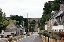 The town and the viaduct of the Paris-Brest railway line | ||
| ||
 Le Ponthou Location within Brittany region  Le Ponthou | ||
| Coordinates: 48°33′58″N 3°38′14″W / 48.5661°N 3.6372°WCoordinates: 48°33′58″N 3°38′14″W / 48.5661°N 3.6372°W | ||
| Country | France | |
| Region | Brittany | |
| Department | Finistère | |
| Arrondissement | Morlaix | |
| Canton | Plouigneau | |
| Intercommunality | Morlaix | |
| Government | ||
| • Mayor (2014–2020) | Jean-Paul Minec | |
| Area1 | 1.34 km2 (0.52 sq mi) | |
| Population (2008)2 | 165 | |
| • Density | 120/km2 (320/sq mi) | |
| Time zone | UTC+1 (CET) | |
| • Summer (DST) | UTC+2 (CEST) | |
| INSEE/Postal code | 29219 /29650 | |
| Elevation | 72–162 m (236–531 ft) | |
|
1 French Land Register data, which excludes lakes, ponds, glaciers > 1 km2 (0.386 sq mi or 247 acres) and river estuaries. 2 Population without double counting: residents of multiple communes (e.g., students and military personnel) only counted once. | ||
.svg.png)
Le Ponthou (Breton: Ar Pontoù) is a commune in the Finistère department of Brittany in north-western France.
Population
Inhabitants of Le Ponthou are called in French Ponthousiens.
See also
References
- Mayors of Finistère Association (in French)
| Wikimedia Commons has media related to Le Ponthou. |
This article is issued from
Wikipedia.
The text is licensed under Creative Commons - Attribution - Sharealike.
Additional terms may apply for the media files.