Cléder
| Cléder Kleder | ||
|---|---|---|
| Commune | ||
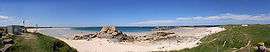 Les Amiets beach | ||
| ||
 Cléder Location within Brittany region  Cléder | ||
| Coordinates: 48°39′51″N 4°06′03″W / 48.6642°N 4.1008°WCoordinates: 48°39′51″N 4°06′03″W / 48.6642°N 4.1008°W | ||
| Country | France | |
| Region | Brittany | |
| Department | Finistère | |
| Arrondissement | Morlaix | |
| Canton | Saint-Pol-de-Léon | |
| Intercommunality | Baie du Kernic | |
| Government | ||
| • Mayor (2014–2020) | Gérard Daniélou | |
| Area1 | 37.44 km2 (14.46 sq mi) | |
| Population (2008)2 | 3,814 | |
| • Density | 100/km2 (260/sq mi) | |
| Time zone | UTC+1 (CET) | |
| • Summer (DST) | UTC+2 (CEST) | |
| INSEE/Postal code | 29030 /29233 | |
| Elevation | 0–79 m (0–259 ft) | |
|
1 French Land Register data, which excludes lakes, ponds, glaciers > 1 km2 (0.386 sq mi or 247 acres) and river estuaries. 2 Population without double counting: residents of multiple communes (e.g., students and military personnel) only counted once. | ||
.svg.png)
Cléder (Breton: Kleder) is a commune in the Finistère department of Brittany in north-western France.
Population
Inhabitants of Cléder are called in French Clédérois.
| Year | 1968 | 1975 | 1982 | 1990 | 1999 | 2008 |
|---|---|---|---|---|---|---|
| Population | 4275 | 3923 | 3928 | 3801 | 3641 | 3814 |
Breton language
In 2008, 25.9% of primary-school children attended bilingual schools.[1]
International relations
Cléder is twinned with Ashburton![]()
![]()
![]()
See also
References
- ↑ (in French) Ofis ar Brezhoneg: Enseignement bilingue
- Mayors of Finistère Association (in French);
External links
| Wikimedia Commons has media related to Cléder. |
- Official website (in French)
- French Ministry of Culture list for Cléder (in French)
This article is issued from
Wikipedia.
The text is licensed under Creative Commons - Attribution - Sharealike.
Additional terms may apply for the media files.