Plomodiern
| Plomodiern Ploudiern | ||
|---|---|---|
| Commune | ||
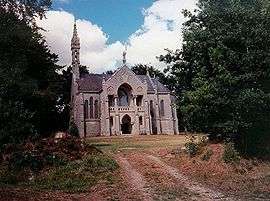 Chapel of Saint Corentin, Plomodiern | ||
| ||
 Plomodiern Location within Brittany region  Plomodiern | ||
| Coordinates: 48°10′55″N 4°13′50″W / 48.1819°N 4.2306°WCoordinates: 48°10′55″N 4°13′50″W / 48.1819°N 4.2306°W | ||
| Country | France | |
| Region | Brittany | |
| Department | Finistère | |
| Arrondissement | Châteaulin | |
| Canton | Crozon | |
| Intercommunality | Pays de Châteaulin et du Porzay | |
| Government | ||
| • Mayor (2014–2020) | Claude Bellin | |
| Area1 | 46.74 km2 (18.05 sq mi) | |
| Population (2008)2 | 2,162 | |
| • Density | 46/km2 (120/sq mi) | |
| Time zone | UTC+1 (CET) | |
| • Summer (DST) | UTC+2 (CEST) | |
| INSEE/Postal code | 29172 /29550 | |
| Elevation | 0–249 m (0–817 ft) | |
|
1 French Land Register data, which excludes lakes, ponds, glaciers > 1 km2 (0.386 sq mi or 247 acres) and river estuaries. 2 Population without double counting: residents of multiple communes (e.g., students and military personnel) only counted once. | ||
.svg.png)
Plomodiern (Breton: Ploudiern) is a commune in the Finistère department of Brittany in north-western France.
Population
Inhabitants of Plomodiern are called in French Plomodiernois. The village is located next to the Menez Hom.
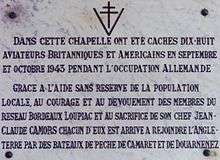
Plaque commemorating the Resistance
See also
References
- Mayors of Finistère Association (in French)
External links
- Official website (in French)
- French Ministry of Culture list for Plomodiern (in French)
| Wikimedia Commons has media related to Plomodiern. |
This article is issued from
Wikipedia.
The text is licensed under Creative Commons - Attribution - Sharealike.
Additional terms may apply for the media files.