Ploudaniel
| Ploudaniel Plouzeniel | ||
|---|---|---|
| Commune | ||
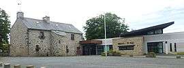 The town hall in Ploudaniel | ||
| ||
 Ploudaniel Location within Brittany region  Ploudaniel | ||
| Coordinates: 48°32′15″N 4°18′37″W / 48.5375°N 4.3103°WCoordinates: 48°32′15″N 4°18′37″W / 48.5375°N 4.3103°W | ||
| Country | France | |
| Region | Brittany | |
| Department | Finistère | |
| Arrondissement | Brest | |
| Canton | Lesneven | |
| Intercommunality | Pays de Lesneven et de la Côte des Légendes | |
| Government | ||
| • Mayor (2014–2020) | Joël Marchadour | |
| Area1 | 46.28 km2 (17.87 sq mi) | |
| Population (2008)2 | 3,683 | |
| • Density | 80/km2 (210/sq mi) | |
| Time zone | UTC+1 (CET) | |
| • Summer (DST) | UTC+2 (CEST) | |
| INSEE/Postal code | 29179 /29260 | |
| Elevation | 27–121 m (89–397 ft) | |
|
1 French Land Register data, which excludes lakes, ponds, glaciers > 1 km2 (0.386 sq mi or 247 acres) and river estuaries. 2 Population without double counting: residents of multiple communes (e.g., students and military personnel) only counted once. | ||

Ploudaniel (Breton: Plouzeniel) is a commune in the Finistère department of Brittany in north-western France.
Population
Inhabitants of Ploudaniel are called in French Ploudaniélois.
| Year | 1962 | 1968 | 1975 | 1982 | 1990 | 1999 | 2008 |
|---|---|---|---|---|---|---|---|
| Population | 2630 | 2511 | 2558 | 3044 | 3406 | 3572 | 3683 |
Breton language
The municipality launched a linguistic plan through Ya d'ar brezhoneg on February 2, 2007.
See also
References
- Mayors of Finistère Association (in French)
External links
| Wikimedia Commons has media related to Ploudaniel. |
This article is issued from
Wikipedia.
The text is licensed under Creative Commons - Attribution - Sharealike.
Additional terms may apply for the media files.