Yarlung Tsangpo River
| Yarlung Tsangpo yar klung gtsang po ཡར་ཀླུང་གཙང་པོ། 雅鲁藏布江 | |
|---|---|
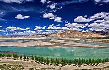
 Yarlung Tsangpo southwest of Lhasa | |
| Country | China, India, Bangladesh |
| Physical characteristics | |
| Main source | Angsi Glacier in Shigatse, Tibet Autonomous Region, China |
| Length | 2,840 km (1,760 mi) |
| Discharge |
|
| Basin features | |
| Basin size | 912,000 km2 (352,000 sq mi) |
| Tributaries | |
Yarlung Tsangpo (sometimes called Yarlung Zangbo or Yarlung Zangbo Jiang (Tibetan: ཡར་ཀླུངས་གཙང་པོ་, Wylie: yar kLungs gTsang po, ZYPY: Yarlung Zangbo ), or Yalu Zangbu River (simplified Chinese: 雅鲁藏布江; traditional Chinese: 雅魯藏布江; pinyin: Yǎlǔ Zàngbù Jiāng) is the longest river of Tibet Autonomous Region, China.[1] The part Tsangpo probably originates from the fact that the river flows from or through Tsang- encompassing the part of Tibet west of Lhasa.
It is the upper stream of the Brahmaputra River. Originating at Angsi Glacier in western Tibet, southeast of Mount Kailash and Lake Manasarovar, it later forms the South Tibet Valley and Yarlung Tsangpo Grand Canyon before passing into the state of Arunachal Pradesh, India.
Downstream from Arunachal Pradesh the river becomes phenomenally wider and is called the Siang. After reaching Assam, the river is known as Brahmaputra. From Assam, the river enters Bangladesh at Ramnabazar. From there until about 200 years ago it used to flow eastward and joined the Meghna River near Bhairab Upazila. This old channel has been gradually dying. At present the main channel of the river is called Jamuna River, which flows southward to meet Ganges, which in Bangladesh is called the Padma.
When leaving the Tibetan Plateau, the River forms the world's largest and deepest canyon, Yarlung Tsangpo Grand Canyon.[2]
Description
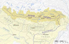

The Yarlung Tsangpo River is the highest major river in the world. Its longest tributary is the Nyang River. Major tributaries of Yarlung Tsangpo include Nyangchu River, Lhasa River, Nyang River, and Parlung Tsangpo.
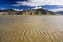
In Tibet the river flows through the South Tibet Valley, which is approximately 1,200 kilometres (750 mi) long and 300 kilometres (190 mi) wide. The valley descends from 4,500 metres (14,800 ft) above sea level to 3,000 metres (9,800 ft).[3][4] As it descends, the surrounding vegetation changes from cold desert to arid steppe to deciduous scrub vegetation. It ultimately changes into a conifer and rhododendron forest. The tree line is approximately 3,200 metres (10,500 ft).[5] Sedimentary sandstone rocks found near the Tibetan capital of Lhasa contain grains of magnetic minerals that record the Earth's alternating magnetic field current.[6]
The basin of the Yarlung River, bounded by the Himalayas in the south and Kang Rinpoche and Nyenchen Tanglha Mountains in the north, has less severe climate than the more northern (and higher-altitude) parts of Tibet, and is home to most of the population of the Tibetan Autonomous Region.
The Yarlung Tsangpo Grand Canyon, formed by a horse-shoe bend in the river where it leaves the Tibetan Plateau and flows around Namcha Barwa, is the deepest, and possibly longest canyon in the world.[7]
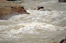
The Yarlung Tsangpo River has three major waterfalls in its entire course.[8] The largest waterfall of the river, the "Hidden Falls", was not publicized in the West until 1998, when its sighting by Westerners was briefly hailed as a "discovery."[9] They were even portrayed as the discovery of the great falls which had been the topic of stories told to early Westerners by Tibetan hunters and Buddhist monks, but which had never been found by Western explorers at the time.[10] The Chinese authorities protested, however, saying that Chinese geographers, who had explored the gorge since 1973, had already taken pictures of the falls in 1987 from a helicopter.[11]
Kayak exploration
Since the 1990s the Yarlung Tsangpo River has been the destination of a number of teams that engage in exploration and whitewater kayaking.[12] The river has been called the “Everest of Rivers” because of the extreme conditions of the river.[13] The first attempt to run was made in 1993 by a Japanese group who lost one member on the river.
In October 1998, a kayaking expedition sponsored by the National Geographic Society attempted to navigate the Yarlung Tsangpo Grand Canyon. Troubled by unanticipated high water levels, the expedition ended in tragedy when expert kayaker Doug Gordon lost his life.[14]
In January–February, 2002, an international group consisting of Scott Lindgren, Steve Fisher, Mike Abbott, Allan Ellard, Dustin Knapp, and Johnnie and Willie Kern, completed the first descent of the upper Tsangpo gorge section.[15]
References
- ↑ Yue-man Yeung & Jianfa Shen 2004.
- ↑ "The New largest Canyon in the world - The Great Canyon of Yalung Tsangpu River (Tibet)". www.100gogo.com. Archived from the original on 2008-02-28. Retrieved 2009-07-19.
- ↑ Yang Qinye & Zheng Du. Tibetan Geography. China Intercontinental Press. pp. 30–31. ISBN 7508506650.
- ↑ Zheng Du, Zhang Qingsong, Wu Shaohong: Mountain Geoecology and Sustainable Development of the Tibetan Plateau (Kluwer 2000), ISBN 0-7923-6688-3, p. 312;
- ↑ "Yarlung Tsangpo arid steppe". Terrestrial Ecoregions. World Wildlife Fund. Retrieved 2007-06-29.
- ↑ "Yarlung Tsangpo River in China". Atmospheric Data Science Center. Retrieved 2007-06-27.
- ↑ "The World's Biggest Canyon". www.china.org. Retrieved 2007-06-29.
- ↑ "Hidden Falls". WWD - Waterfall Database. Retrieved 2007-06-30.
- ↑ "Fabled Tibetan Waterfalls Finally Discovered". Archived from the original on 2007-09-27. Retrieved 2007-07-07.
- ↑ Compiled by Nima Dorjee (7 January, 1999). Fabled Tibetan Waterfalls Finally Discovered. World Tibet Network News. Published by The Canada Tibet Committee. Issue ID: 99/01/07 Archived 2007-09-27 at the Wayback Machine. (retrieved on 14 September 2008)
- ↑ Peter Heller (July 2002). Liquid Thunder. Outside Online. (retrieved on 14 September 2008)
Antonio Perezgrueso (undated). The Echo of Liquid Thunder. (span. original: Los ecos del trueno líquido) Explorations and Expeditions on the English pages of the Sociedad Geográfica Española (retrieved on 14 September 2008)
Who found it first? no longer existing website, quoted without further information on The Ancients. Shangri-La Found as: "Little attention was paid to the Chinese team that had been striking for the falls during that fateful trekking season. They claimed to have reached the falls before Baker but were ignored for the most part by everybody except their government who decided to close the gorge to westerners." (retrieved on 14 September 2008) - ↑ "Tibet Hidden Falls | The Hidden Lands of Tibet". Retrieved 2017-03-16.
- ↑ Press release of successful kayak run
- ↑ Doug Gordon
- ↑ Heller, Peter. "Tsangpo Expedition: Liquid Thunder". Outside Magazine. Outside Online. Retrieved 2009-02-07.
Bibliography
- Yue-man Yeung; Jianfa Shen (2004), Developing China's West: A Critical Path to Balanced National Development, Chinese University Press, p. 553, ISBN 978-9-62-996157-2
External links
- River from Heaven Documentary film by CNTV (Chinese)
| Wikimedia Commons has media related to Yarlung Tsangpo. |