Zayü County
| Zayü County 察隅县 • རྫ་ཡུལ་རྫོང་། | |
|---|---|
| County | |
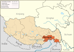
.png) Location of Zayü County within Nyingchi Prefecture, Tibet, and the PRC | |
 Zayü Location in Tibet | |
| Coordinates: 28°40′N 97°28′E / 28.667°N 97.467°E | |
| Country | People's Republic of China |
| Region | Tibet |
| Prefecture | Nyingchi |
| Area | |
| • Total | 31,305 km2 (12,087 sq mi) |
| Elevation | 2,330 m (7,640 ft) |
| Population (2010)[1] | |
| • Total | 27,255 |
| • Density | 0.87/km2 (2.3/sq mi) |
| Time zone | UTC+8 (China Standard) |
Zayü County (Chinese: 察隅县; pinyin: Cháyú Xiàn) is a county of the Nyingtri Prefecture in the southeast of the Tibet Autonomous Region, bordering India and Burma to the south and Yunnan province to the southeast.
Chinese claims include parts of Arunachal Pradesh, south of the McMahon Line, what was casus belli for the 1962 Sino-Indian War.
Geography and climate
Zayü County is located in an area of highly varying topography, lying just south of the Tibetan Plateau in the mountainous region east of the Himalayas where the Transhimalayas transition to the Hengduan Mountains. Specifically, Zayü straddles the southern parts of the Baxoila Range, the eastern parts of the Kangri Garpo mountains, and the eastern parts of the Mishmi Hills.[2] Elevations generally decrease from northwest to southeast, with a maximal variation of 3,600 metres (11,800 ft): in the county, areas near the southern border have an elevation of 1,400 metres (4,600 ft),[3] while there are 10 peaks over 5,000 metres (16,000 ft),[3] the highest being Kawagarbo in the Meili Xue Shan at 6,740 metres (22,110 ft). The county has an average elevation of 2,300 metres (7,500 ft).[3] The primary rivers are the Zayü River through the central parts of the county and Nu River (Salween) in the east.
The county has an area of 31,305 square kilometres (12,087 sq mi).[3] Besides India, Burma, and Yunnan, Zayü borders Zogang County to the north and Mêdog County to the southwest.
Owing to its moderate elevation (for Tibet), Zayü has a subtropical highland climate (Köppen Cwb), a rarity in Tibet, with mild and quite dry winters, and warm, rainy summers. The rainy season lasts from March to September, and June through August each average more than 20 days of rainfall per month. The monthly daily average temperature ranges from 5.5 °C (41.9 °F) in January to 19.9 °C (67.8 °F) in July, and the annual mean is 13.09 °C (55.6 °F). The frost-free period is 280 days annually. Here, the diurnal temperature range is not large, maxing out at 13.5 °C (24.3 °F) in November.[3]
| Climate data for Zayü (1971−2000) | |||||||||||||
|---|---|---|---|---|---|---|---|---|---|---|---|---|---|
| Month | Jan | Feb | Mar | Apr | May | Jun | Jul | Aug | Sep | Oct | Nov | Dec | Year |
| Record high °C (°F) | 19.0 (66.2) |
21.6 (70.9) |
24.2 (75.6) |
28.9 (84) |
30.2 (86.4) |
31.6 (88.9) |
31.9 (89.4) |
31.1 (88) |
30.3 (86.5) |
29.5 (85.1) |
22.8 (73) |
19.8 (67.6) |
31.9 (89.4) |
| Average high °C (°F) | 11.4 (52.5) |
12.2 (54) |
14.0 (57.2) |
17.0 (62.6) |
21.7 (71.1) |
24.0 (75.2) |
24.7 (76.5) |
24.9 (76.8) |
23.3 (73.9) |
20.4 (68.7) |
16.8 (62.2) |
13.2 (55.8) |
18.6 (65.5) |
| Daily mean °C (°F) | 5.5 (41.9) |
6.7 (44.1) |
8.8 (47.8) |
11.7 (53.1) |
16.1 (61) |
19.1 (66.4) |
19.9 (67.8) |
19.8 (67.6) |
18.4 (65.1) |
14.5 (58.1) |
10.0 (50) |
6.6 (43.9) |
13.1 (55.6) |
| Average low °C (°F) | −0.4 (31.3) |
1.2 (34.2) |
3.6 (38.5) |
6.4 (43.5) |
10.6 (51.1) |
14.3 (57.7) |
15.2 (59.4) |
14.8 (58.6) |
13.6 (56.5) |
8.7 (47.7) |
3.3 (37.9) |
0.0 (32) |
7.6 (45.7) |
| Record low °C (°F) | −5.5 (22.1) |
−5 (23) |
−2.4 (27.7) |
−0.2 (31.6) |
2.5 (36.5) |
8.0 (46.4) |
9.5 (49.1) |
8.5 (47.3) |
6.0 (42.8) |
0.9 (33.6) |
−2.9 (26.8) |
−4.4 (24.1) |
−5.5 (22.1) |
| Average precipitation mm (inches) | 14.1 (0.555) |
30.7 (1.209) |
91.4 (3.598) |
129.4 (5.094) |
74.0 (2.913) |
83.0 (3.268) |
108.4 (4.268) |
108.4 (4.268) |
76.5 (3.012) |
61.3 (2.413) |
18.1 (0.713) |
12.4 (0.488) |
807.7 (31.799) |
| Average precipitation days (≥ 0.1 mm) | 6.2 | 10.6 | 17.4 | 18.4 | 17.9 | 20.4 | 22.3 | 22.7 | 19.0 | 11.8 | 5.4 | 3.0 | 175.1 |
| Source: Weather China[3] | |||||||||||||
Environment
The central parts of Zayü County contain a large isolated section of the Northeastern Himalayan subalpine conifer forests throughout the Zayü River valley and its tributaries.[4] The highland areas of Zayü contain Eastern Himalayan alpine shrub and meadows.[5] The eastern parts of the county are classified as Nujiang Langcang Gorge alpine conifer and mixed forests.[6] There are, however, extremely dry areas within the Nu Valley in Zayü that support mostly succulents.
Administrative divisions
Zayü County has administration over three towns and three townships:
- Zayü Town (Chinese: 竹瓦根镇; pinyin: Zhúwǎgēn Zhèn) - County seat, formerly known as Rima
- Lower Dzayül Town (Chinese: 下察隅镇; pinyin: Xià Cháyú Zhèn)
- Upper Dzayül Town (Chinese: 上察隅镇; pinyin: Shàng Cháyú Zhèn)
- Goyü Township (Chinese: 古玉乡; pinyin: Gǔyù Xiāng)
- Golag Township (Chinese: 古拉乡; pinyin: Gǔlā Xiāng)
- Cawarong Township (Chinese: 察瓦龙乡; pinyin: Cháwǎlóng Xiāng)
There are also numerous villages scattered throughout the valleys in Zayü County administered by their respective towns or townships. Puzang is part of Upper Dzayül and Shaqiong is part of Lower Dzayül.
References
- ↑ "Cháyú Xiàn". City Population. Thomas Brinkhoff. Retrieved 29 August 2017.
- ↑ Atlas of China. Beijing, China: SinoMaps Press. 2006. ISBN 9787503141782.
- 1 2 3 4 5 6 察隅 - 气象数据 -中国天气网 (in Chinese). Weather China. Retrieved 2012-06-17.
- ↑ "Northeastern Himalayan subalpine conifer forests". Global Species. Myers Enterprises II. Retrieved 28 August 2017.
- ↑ "Eastern Himalayan alpine shrub and meadows". Global Species. Myers Enterprises II. Retrieved 28 August 2017.
- ↑ "Nujiang Langcang Gorge alpine conifer and mixed forests". Global Species. Myers Enterprises II. Retrieved 28 August 2017.