Nyima County
| Nyima County 尼玛县 • ཉི་མ་རྫོང་། | |
|---|---|
| County | |
.png) Location of Nyima County within Tibet (outdated map, shows the situation in 2007, before the establishment of Shuanghu County in 2012) | |
| Coordinates: 34°06′35″N 87°50′31″E / 34.10972°N 87.84194°E | |
| Country | China |
| Province | Tibet |
| Prefecture-level city | Nagqu |
| Capital | [[]] |
| Time zone | UTC+8 (China Standard) |
Nyima County (Tibetan སོག་རྫོང་ Wylie sog rdzong; Chinese: 尼玛县; Pinyin: Nímǎ Xiàn) is the westernmost county-level division within Nagqu prefecture, Tibet Autonomous Region, People's Republic of China. The northern part of the county is within the Changtang area.
With an area of 72,499 km2 and a population of 29,000 (2012), it has an average population density of less than 0.4 people per square kilometre. It is situated in the central-northern part of the Tibetan Plateau, between Nagqu's Shuanghu County to the east and Ngari's Gêrzê County to the west.
| District | 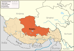 | |
|---|---|---|
| Counties | ||
| Towns and villages |
| |
| Geography |
| |
Coordinates: 34°06′35″N 87°50′31″E / 34.10972°N 87.84194°E
This article is issued from
Wikipedia.
The text is licensed under Creative Commons - Attribution - Sharealike.
Additional terms may apply for the media files.