Shuanghu County
| Shuanghu County 双湖县 • མཚོ་གཉིས་རྫོང་། | |
|---|---|
| County | |
 Location of Shuanghu Special District (outdated map, situation before 2012) | |
| Country | China |
| Province | Tibet |
| Prefecture-level city | Nagqu |
| Area | |
| • Total | 116,700 km2 (45,100 sq mi) |
| Elevation | 4,960 m (16,270 ft) |
| Population (2014) | |
| • Total | 13,470 [1] |
| • Density | 0.12/km2 (0.3/sq mi) |
| Time zone | UTC+8 (China Standard) |
| Shuanghu County | |||||||
| Chinese name | |||||||
|---|---|---|---|---|---|---|---|
| Simplified Chinese | 双湖县 | ||||||
| Traditional Chinese | 雙湖縣 | ||||||
| |||||||
| Alternative Chinese name | |||||||
| Simplified Chinese | 错尼县 | ||||||
| Traditional Chinese | 錯尼縣 | ||||||
| |||||||
| Tibetan name | |||||||
| Tibetan | མཚོ་གཉིས་རྫོང་། | ||||||
| |||||||
Shuanghu County (Chinese: 双湖县), also transliterated from Tibetan as Co'nyi County (Tibetan: མཚོ་གཉིས་རྫོང་། ; Chinese: 错尼县; literally: "twin lake county"), is a county-level division within Nagqu prefecture, Tibet Autonomous Region, People's Republic of China. It was formed in 2012, combining the territory of the former Shuanghu Special District (双湖特别区) with the eastern half of Nyima County. Much of the county is within the Changtang area.
Shuanghu (Tibetan Tshonyi; mtsho gnyis) translates to "two lakes". Shuanghu County is at very high elevation, mostly above 5,000 meters above sea level, and very sparsely populated (averaging around 0.12 people per square kilometre, but concentrated in the southern portion of the county). The vast majority of its population practices nomadic pastoralism (mostly goats and sheep).[2] The climate is very rough, cold and dry. There is a weather station in Shuanghu, established in 1999,[3] which on average measures negative temperatures (Celsius scale) throughout the year. The highest temperature on record is +2.3 °C (July 2000), the lowest −62.4 °C (January 2006).
The county comprises seven town-level divisions: the administrative center at Cuozheluomazhen (Cozhêlhoma, Soggarluma) 措折罗玛镇 (31°54′07″N 87°53′13″E / 31.902°N 87.887°E), and the six townships Xibdê 协德乡, Yagqu 雅曲乡, Garco 嘎措乡 Cozhêdangma 措折强玛乡, Domar 多玛乡, Parling 巴岭乡.
Purog Kangri Glacier (普若岗日), near Purog Kangri Peak (33°55′26″N 89°12′40″E / 33.924°N 89.211°E, reported at 6,482 m or 6,435 m)[4] has been reported as the world's largest "third largest glacier" (i.e. the largest outside the two polar regions), at 422 km2 as of 2009, but reportedly melting at "an accelerated rate" (Xinhua).[5]
See also
References
- ↑
- ↑ Daniel J. Miller, Nomads of the Tibetan Plateau Rangelands in Western China Part Two: Pastoral Production Practices, Rangelands 21(1) (1999) p. 18.
- ↑ accuweather.com
- ↑ Not to be confused with the Zangser Kangri Group, 6,460 m. Janusz Majer, Kangri and Jomo Ri Massifs, Reconaissance(sic), Mayer Kangri I East (6,053m) Alpina Americana (2010).
- ↑ cas.cn (11 July 2017).
External links
- World's highest county established in Tibet, China.org.cn, July 26, 2013.
| District | 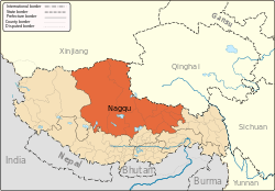 | |
|---|---|---|
| Counties | ||
| Towns and villages |
| |
| Geography |
| |
Coordinates: 33°11′32″N 88°50′10″E / 33.19222°N 88.83611°E