Gar County
| Gar County 噶尔县 • སྒར་རྫོང་། | |
|---|---|
| County | |
.png) Location of Gar County within Tibet Autonomous Region | |
| Country | People's Republic of China |
| Autonomous region | Tibet Autonomous Region |
| Prefecture | Ngari Prefecture |
| Seat | Shiquanhe (Gar) |
Gar County (Tibetan: སྒར་རྫོང་།, Wylie: sgar rdzong, ZYPY: Gar Zong ; simplified Chinese: 噶尔县; traditional Chinese: 噶爾縣; pinyin: Gá'ěr Xiàn) is a county in the Ngari Prefecture of the western Tibet Autonomous Region of China. The main town is Shiquanhe, once known as the city of "Gar" and often known as "Ali" in English.
Geology
Main rivers in the county include Sênggê Zangbo and Gar Zangbo.
| Climate data for Shiquanhe | |||||||||||||
|---|---|---|---|---|---|---|---|---|---|---|---|---|---|
| Month | Jan | Feb | Mar | Apr | May | Jun | Jul | Aug | Sep | Oct | Nov | Dec | Year |
| Record high °C (°F) | 6.4 (43.5) |
9.5 (49.1) |
13.4 (56.1) |
15.7 (60.3) |
20.5 (68.9) |
25.2 (77.4) |
32.1 (89.8) |
26.4 (79.5) |
23.7 (74.7) |
16.7 (62.1) |
12.7 (54.9) |
7.1 (44.8) |
32.1 (89.8) |
| Average high °C (°F) | −4.1 (24.6) |
−2.0 (28.4) |
2.3 (36.1) |
7.4 (45.3) |
12.6 (54.7) |
18.1 (64.6) |
21.5 (70.7) |
20.5 (68.9) |
16.3 (61.3) |
8.2 (46.8) |
2.9 (37.2) |
−1.6 (29.1) |
8.5 (47.3) |
| Daily mean °C (°F) | −12.0 (10.4) |
−9.2 (15.4) |
−4.8 (23.4) |
0.1 (32.2) |
5.1 (41.2) |
10.7 (51.3) |
14.4 (57.9) |
13.8 (56.8) |
9.3 (48.7) |
0.5 (32.9) |
−5.7 (21.7) |
−10.1 (13.8) |
1 (33.8) |
| Average low °C (°F) | −19.7 (−3.5) |
−16.9 (1.6) |
−12.6 (9.3) |
−7.9 (17.8) |
−2.7 (27.1) |
3.1 (37.6) |
7.7 (45.9) |
7.5 (45.5) |
2.0 (35.6) |
−8.0 (17.6) |
−14.8 (5.4) |
−18.2 (−0.8) |
−6.7 (19.9) |
| Record low °C (°F) | −36.6 (−33.9) |
−30.2 (−22.4) |
−25.3 (−13.5) |
−17.9 (−0.2) |
−11.2 (11.8) |
−6.6 (20.1) |
−0.6 (30.9) |
−0.4 (31.3) |
−10.0 (14) |
−17.0 (1.4) |
−23.5 (−10.3) |
−32.9 (−27.2) |
−36.6 (−33.9) |
| Average precipitation mm (inches) | 1.6 (0.063) |
1.2 (0.047) |
1.4 (0.055) |
1.3 (0.051) |
2.9 (0.114) |
3.7 (0.146) |
21.4 (0.843) |
23.8 (0.937) |
5.7 (0.224) |
2.0 (0.079) |
0.3 (0.012) |
1.1 (0.043) |
66.4 (2.614) |
| Source: China Meteorological Administration,[1] | |||||||||||||
Transport
| County-level divisions | 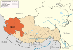 | |
|---|---|---|
| Towns and villages | ||
| Geography | ||
| Landmarks | ||
References
- ↑ 中国地面国际交换站气候标准值月值数据集(1981-2010年) (in Chinese). China Meteorological Administration. Retrieved January 1, 2011.
Coordinates: 32°05′49″N 80°21′23″E / 32.09694°N 80.35639°E
This article is issued from
Wikipedia.
The text is licensed under Creative Commons - Attribution - Sharealike.
Additional terms may apply for the media files.