Kham

Kham (Tibetan: ཁམས་, Wylie: khams ; Chinese: 康; pinyin: Kāng) is a historical region of Tibet covering a land area largely divided between present-day Tibet Autonomous Region and Sichuan, with smaller portions located within Qinghai, Gansu and Yunnan provinces of China. During the Republic of China's rule over mainland China (1911–1949), most of the region was administratively part of Hsikang (Chinese: 西康). It held the status of "special administrative district" until 1939, when it became an official Chinese province. Its provincial status was nominal and without much cohesion, like most of China's territory during the time of Japanese invasion and civil war. The natives of the Kham region are called Khampas (Tibetan: ཁམས་པ་, Wylie: khams pa ).
Geography
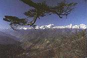
Kham has a rugged terrain characterized by mountain ridges and gorges running from northwest to southeast, and collectively known as the Hengduan Mountains. Numerous rivers, including the Mekong, Yangtze, Yalong River, and the Salween River flow through Kham.
Under the modern administrative division of China, Kham includes a total of 50 contemporary counties of the People's Republic of China which have been incorporated into the Chinese provinces of Sichuan (16 counties), Yunnan (three counties), and Qinghai (six counties) as well as the eastern portion of the Tibet Autonomous Region (25 counties).
Ethnic groups
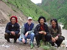
Some Chinese linguists and anthropologists refer to Kham as the "Ethnic Corridor of Southwest China", as its vast and sparsely populated territories are inhabited by over 14 culturally and linguistically distinct ethnic groups. For reasons of simplicity, the Chinese government combines the various ethnic groups of Kham together with the Tibetan people as the "Tibetan Nationality". There are, however, significant differences in traditions and beliefs—even physical appearance—between the peoples of Kham and Lhasa. At least one-third of Kham residents are speakers of Qiangic languages, a family of twelve distinct but interrelated languages that are not closely related to Khams Tibetan.
The people of Kham were reputed warriors renowned for their marksmanship and horsemanship.[1]
History
Kham was traditionally referred to as Chushi Gangdruk, i.e. 'four rivers and six ranges'. The peoples of Kham have endured a tumultuous past, their sovereignty often encroached upon and marginalized by both Tibetans to the west and the Han Chinese to the East. The five main independent regions were the Kingdom of Chakla, Derge, the Kingdom of Lingtsang, Nangchen and the Kingdom of Lhatok. Other important polities included Nangqen, Chamdo, Batang, Mili, and the Hor States.
Kham was never controlled by a single king, but most of the chieftains revered the Dalai Lamas and often made contact with the Lhasa government. Kham was a patchwork of two dozen or more kingdoms, tribes, and chiefdoms that were constantly at war with each other. Since the collapse of the Tibetan Empire in the mid-9th century, the peoples of Kham had aggressively maintained their independence from invading nations. Local chieftains ruled their respective territories with hereditary titles bestowed by the Chinese government. Chieftains were able to rule with a large degree of independence from both China and Tibet.[2]
In 1717, the Mongol Dzungar Khanate invaded Tibet and a period of internal strife and civil war followed. By 1720, local Tibetan leaders had pledged their allegiance to China and the Qing dynasty had sent armies into the area to defeat the Dzungars. In 1724, the regions of Amdo and Kham were made into the province of Qinghai (Kokonor), with parts of Eastern Kham incorporated into neighboring Chinese provinces.[3]
In the early 19th century, Gombo Namgye raised a rebellion in Nyarong, an area of Eastern Kham. He is reported to have taken control of Eastern Tibet, excepting Amdo. Residents of Derge and the Hor States appealed to both Lhasa and the Manchu government for help against Namgye. China was unable to take action, but Tibetan authorities sent an army in 1863 and defeated Namgye in 1865. Tibet then claimed Nyarong, Derge (or De-ge) and the Hor States north of Nyarong. This appears to have been accepted by the then Manchu Tongzhi Emperor.[4]
Tibetan control of the Batang region of Kham appears to have continued uncontested from an agreement made in 1726[5] until soon after the invasion of Tibet by Francis Younghusband in 1904, which alarmed the Qing rulers in China. They sent an imperial official to the region to begin reasserting Qing control, but the locals revolted and killed him. The Qing government in Beijing then appointed Zhao Erfeng, the Governor of Xining and Army Commander of Tibet to reintegrate Tibet into China. In 1905 or 1908[6][7] Erfeng was sent on a punitive expedition and began destroying many monasteries in Kham and Amdo, implementing sinicization of the region:[8]
He abolished the powers of the Tibetan local leaders and appointed Chinese magistrates in their places. He introduced new laws that limited the number of lamas and deprived monasteries of their temporal power and inaugurated schemes for having the land cultivated by Chinese immigrants.
Zhao's methods in eastern Tibet uncannily prefigured the Communist policies nearly half a century later. They were aimed at the extermination of the Tibetan clergy, the assimilation of territory and repopulation of the Tibetan plateaus with poor peasants from Sichuan. Like the later Chinese conquerors, Zhao's men looted and destroyed Tibetan monasteries, melted down religious images and tore up sacred texts to use to line the soles of their boots and, as the Communists were also to do later, Zhao Erfeng worked out a comprehensive scheme for the redevelopment of Tibet that covered military training reclamation work, secular education, trade and administration.[9]
In February 1910, the Qing government sent a military expedition of its own to establish direct Chinese rule, deposing the 13th Dalai Lama and issuing an imperial edict prompting a search for a new incarnation, though it was largely ignored in Tibet.[10] The Dalai Lama fled to British India where he friended Charles Alfred Bell, a British diplomatic officer stationed in Sikkim and a critic of Great Britain's policies in the region. "By going in and then coming out again, we knocked the Tibetans down and left them for the first comer to kick," wrote Bell later. The situation was soon to change, as after the fall of the Qing dynasty in October 1911, Zhao's soldiers mutinied and beheaded him.[9]
The official position of the British Government was it would not intervene between China and Tibet and would only recognize the de facto government of China within Tibet at this time.[11] In his history of Tibet, Bell wrote that "the Tibetans were abandoned to Chinese aggression, an aggression for which the British Military Expedition to Lhasa and subsequent retreat [and consequent power vacuum within Tibet] were primarily responsible".[11] Later, Britain defined the Indo-Tibetan border at the 1914 Simla Accord with the McMahon Line. China's delegation refused to agree to the line and still claims the land India received from Tibet as South Tibet, although the McMahon line remains the de facto border.
In 1932, an agreement signed between Chinese warlord Liu Wenhui and Tibetan forces formalized the partition of Kham into two regions: Eastern Kham, which was administered by Chinese forces, and Western Kham, which was administered by Tibet. Eastern Kham subsequently became the actual area of control of China's Xikang province. The border between eastern and western Kham is the Yangtze - Dri Chu in Tibetan and Jinsha Jiang, or Chang Jiang respectively, in Chinese.
Tenpay Gyaltsan, a Khampa who was 5 years old, was selected as the fifth Jamyang Hutuktu in 1921.[12]
The Kham Pandatsang family led the 1934 Khamba rebellion against the Tibetan government in Lhasa. The Kuomintang reached out to the Khampas, whose relationship with the Dalai Lama's government in Lhasa were detereorating badly. The Khampa revolutionary leader Pandatsang Rapga founded the Tibet Improvement Party to overthrow the Tibetan government and establish a Tibetan Republic as part of China. In addition to using the Khampa's against the Tibetan Government in Lhasa, the Chinese Kuomintang also used them against the Communists during the Chinese Civil War.
The Kuomintang formulated a plan where three Khampa divisions would be assisted by the Panchen Lama to oppose the Communists.[13]
Kuomintang intelligence reported that some Tibetan tusi chiefs and the Khampa Su Yonghe controlled 80,000 troops in Sichuan, Qinghai, and Tibet. They hoped to use them against the Communist army.[14]
The Chinese Kuomintang (Nationalists) also enlisted Khampas to join their military.[15]
The Chinese Kuomintang also sought the Khampas help in defending Sichuan from Japan during World War 2, since the temporary capital was located there.[16] A Khampa member of the Mongolian Tibetan Academy was Han Jiaxiang.[17]
300 "Khampa bandits" were enlisted into the Kuomintang's Consolatory Commission military in Sichuan, where they were part of the effort of the central government of China to penetrated and destabilize the local Han warlords such as Liu Wenhui. The Chinese government sought to exercise full control over frontier areas against the warlords. The Consoltary Commission forces were used to battle the Communist Red Army, but were defeated when their religious leader was captured by Communist forces.[18]
The Republic of China government also used Khampa traders to operate secret transports between different places.[19]
Kesang Tsering was sent by the Chinese to Batang to take control of Xikang, where he formed a local government. He was spread there for the purpose of propagating the Three People's Principle to the Khampa.[20]
In 1950, following the defeat of the Kuomintang rulers of China by communist forces in the Chinese Civil War, the People's Liberation Army entered western Kham. Western Kham was then set up as a separate Qamdo Territory (昌都地区), then merged into Tibet Autonomous Region in 1965. Meanwhile, Xikang, comprising eastern Kham, was merged into Sichuan in 1955. The border between Sichuan and Tibet Autonomous Region has remained the Yangtze River. The northernmost region of Kham, Yushu Tibetan Autonomous Prefecture, has been a part of Qinghai since the 18th century.
See also
References
- ↑ "Heinrich Harrer Limited Edition Portfolio: Gallery: Khampa Warriors".
- ↑ Richardson, Hugh E. (1984). Tibet and its History. Second Edition, Revised and Updated, pp. 28-68. Shambhala. Boston & London. ISBN 0-87773-376-7 (pbk)
- ↑ Stein, R. A. (1972) Tibetan Civilization; translated by J. E. Stapleton Driver, p. 88. Stanford University Press, Stanford, California. ISBN 0-8047-0806-1 (cloth); ISBN 0-8047-0901-7 (paper).
- ↑ "What is Tibet? Fact and Fancy". Retrieved 2010-03-02.
- ↑ Abbé Huc. The Land of the Lamas. Taken from: Travels in Tartary, Thibet and China, 1844-1846 by MM. Huc and Gabet, translated by William Hazlitt, p. 123.
- ↑ "Ligne MacMahon." Archived 2013-06-16 at the Wayback Machine.
- ↑ Fossier, Astrid (2004). "L'Inde des britanniques à Nehru : un acteur clé du conflit sino-tibétain". Paris.
- ↑ http://www.tpprc.org/tibet/later_history/
- 1 2 Hilton, Isabel. (1999). The Search for the Panchen Lama. Viking. Reprint: Penguin Books. (2000), p. 115. ISBN 0-14-024670-3.
- ↑ Smith (1996), p. 175
- 1 2 Bell (1924), p. 113
- ↑ Hsiao-ting Lin (2010). Modern China's ethnic frontiers: a journey to the west. Volume 67 of Routledge studies in the modern history of Asia (illustrated ed.). Taylor & Francis. p. 61. ISBN 0-415-58264-4. Retrieved 2011-12-27.
and established a military garrison.35 In 1921, when five-year-old Khampa Tibetan Tenpay Gyaltsan (aka Huang Zhengguang) was identified and enthroned as the new fifth Jamyang Hutuktu, Labrang remained under the Ma family's control.
- ↑ Hsiao-ting Lin (2010). Modern China's ethnic frontiers: a journey to the west. Volume 67 of Routledge studies in the modern history of Asia (illustrated ed.). Taylor & Francis. p. 117. ISBN 0-415-58264-4. Retrieved 2011-12-27.
China's far northwest.23 A simultaneous proposal suggested that, with the support of the new Panchen Lama and his entourage, at least three army divisions of the anti-Communist Khampa Tibetans could be mustered in southwest China.
- ↑ Hsiao-ting Lin (2010). Modern China's ethnic frontiers: a journey to the west. Volume 67 of Routledge studies in the modern history of Asia (illustrated ed.). Taylor & Francis. p. xxi. ISBN 0-415-58264-4. Retrieved 2011-12-27.
(tusi) from the Sichuan-Qinghai border; and Su Yonghe, a Khampa native-chieftain from Nagchuka on the Qinghai- Tibetan border. According to Nationalist intelligence reports, these leaders altogether commanded about 80000 irregulars.
- ↑ Hsiao-ting Lin (2010). Modern China's ethnic frontiers: a journey to the west. Volume 67 of Routledge studies in the modern history of Asia (illustrated ed.). Taylor & Francis. p. 60. ISBN 0-415-58264-4. Retrieved 2011-12-27.
the reorganization of local militia, the recruitment of Khampa aborigines into the Nationalist armies, and the strengthening of the taxation and judicial systems.34 Xikang, however, was not the sole focus of Nationalist frontier
- ↑ Hsiao-ting Lin (2010). Modern China's ethnic frontiers: a journey to the west. Volume 67 of Routledge studies in the modern history of Asia (illustrated ed.). Taylor & Francis. p. 121. ISBN 0-415-58264-4. Retrieved 2011-12-27.
Qinghai and Gansu, who threatened to ally with the Japanese at the early state of the war; and to control Xikang and the local Khampa Tibetans would be to protect the whole of Sichuan, the wartime headquarters of the Nationalists.
- ↑ Hsiao-ting Lin (2010). Modern China's ethnic frontiers: a journey to the west. Volume 67 of Routledge studies in the modern history of Asia (illustrated ed.). Taylor & Francis. p. 33. ISBN 0-415-58264-4. Retrieved 2011-12-27.
His reports and telegrams back to Nanking served as perhaps the most reliable sources of information for Nanking before its final collapse 1949.74 Han Jiaxiang, a native Khampa, was a senior at the Mongolian and Tibetan Academy in
- ↑ Hsiao-ting Lin (2010). Modern China's ethnic frontiers: a journey to the west. Volume 67 of Routledge studies in the modern history of Asia (illustrated ed.). Taylor & Francis. p. 52. ISBN 0-415-58264-4. Retrieved 2011-12-27.
A force of about 300 soldiers was organized and augmented by recruiting local Khampa bandits into the army. The relationship between the Consolatory Commission and Liu Wenhui seriously deteriorated in early 1936, when the Norla Hutuktu
- ↑ Hsiao-ting Lin (2010). Modern China's ethnic frontiers: a journey to the west. Volume 67 of Routledge studies in the modern history of Asia (illustrated ed.). Taylor & Francis. p. 81. ISBN 0-415-58264-4. Retrieved 2011-12-27.
A new pack-transport firm, operated by Khampa-Tibetan traders but covertly backed by Chongqing, was accordingly set up in Dartsendo to manage the route.35 A new branch of the Bank of China was also opened in Kalimpong in northeast India
- ↑ Hsiao-ting Lin (2010). Modern China's ethnic frontiers: a journey to the west. Volume 67 of Routledge studies in the modern history of Asia (illustrated ed.). Taylor & Francis. p. 27. ISBN 0-415-58264-4. Retrieved 2011-12-27.
area and spreading Sun Yat-sen's Three People's Principle among the Tibetan and Khampa minorities, Kesang Tsering set up a field headquarters in Batang (Pa'an). There he appointed his own Xikang provincial government staff and issued an
Further reading
- Andreas Gruschke: The Cultural Monuments of Tibet’s Outer Provinces: Kham, 3 vols. (2 published so far), White Lotus Press, Bangkok 2004. ISBN 974-480-049-6
- Augusta Molnar, The Kham Magar Women Of Thabang (Kathmandu, Nepal: Centre for Economic Development and Administration, Tribhuvan University, 1981).
- Birgit van de Wijer, Tibet's Forgotten Heroes: The Story Of Tibet's Armed Resistance Against China, 1st ed. (Amberley Publishing Limited, 2010), ISBN 9781848689855
- Charles Alfred Bell Tibet, Past & Present (Oxford: Clarendon Press,1924), ISBN 9788120810488
- David Gellne, Resistance And The State: Nepalese Experiences (New York: Berghah Books, 2007), ISBN 9781845452162
- David Molk, Lion Of Siddhas: The Life And Teachings Of Padampa Sangye (Shambhala, 2008), ISBN 9781559398404
- Douglas Wissing, Pioneer In Tibet: The Life And Perils Of Dr. Albert Shelton (St. Martin's Press, 2015), ISBN 9781466892248
- Edward A. Parmee, D.T. Campbell and R.A. LeVine, Kham And Amdo Of Tibet (Human Relations Area Files, 1972).
- Andrew Forbes and David Henley, China's Ancient Tea Horse Road. (Cognoscenti Books, 2011), ISBN 9781300464860
- George Bogle and Thomas Manning, Narratives Of The Mission Of George Bogle To Tibet: And Of The Journey Of Thomas Manning To Lhasa (Cambridge University Press, 2010), ISBN 9781108022552
- Kurtis R Schaeffer, Sources Of Tibetan Tradition (New York: Columbia University Press, 2013), ISBN 9780231509787
- Michael Buckley, Tibet (The Bradt Travel Guide, 2012), ISBN 9781841623825
- Pamela Logan: Tibetan Rescue. The Extraordinary Quest to Save the Sacred Art Treasures of Tibet (Tuttle Publishing 2002), ISBN 9780804834216
- Thomas Laird: The Story of Tibet: Conversation With the Dalai Lama, Grove Press, New York, ISBN 978-0-8021-1827-1
- Tsepon Wangchuk Dedon Shakabpa, One Hundred Thousand Moons: An Advanced Political History Of Tibet (Brill, 2009), ISBN 9789004177321
- Tsering Shakya, The Dragon in the Land of Snows. A History of Modern Tibet Since 1947 (London: Columbia University Press, 1999), ISBN 0-14-019615-3
- Warren Smith, Tibetan Nation: A History Of Tibetan Nationalism And Sino-tibetan Relations (Boulder: Westview, 1996), ISBN 9780813331553
- Xiuyu Wang, China's Last Imperial Frontier: Late Qing Expansion In Sichuan's Tibetan Borderlands, (Lexington Books, 2011), ISBN 9780739168097
- Yudru Tsomu, The Rise of Gönpo Namgyel in Kham: The Blind Warrior of Nyarong. (Lexington Books, 2014), ISBN 9780739177938
External links
| Wikimedia Commons has media related to Kham. |
- Khampa Network
- "Seven Days in Permitless Tibet", magazine article about traveling overland across Kham
Coordinates: 30°36′6.01″N 96°50′29.59″E / 30.6016694°N 96.8415528°E