Lhünzhub County
| Lhünzhub County 林周县 • ལྷུན་གྲུབ་རྫོང་། | |
|---|---|
| County | |
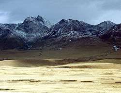 Typical scenery of the Nyainqentanglha Mountains | |
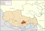
.png) Location of Lhünzhub County within the Tibet Autonomous Region | |
| Coordinates: 30°21′25″N 91°28′30″E / 30.35694°N 91.47500°E | |
| Country | China |
| Region | Tibet Autonomous Region |
| Prefecture-level city | Lhasa |
| County seat | Lhünzhub |
| Area | |
| • Total | 4,512 km2 (1,742 sq mi) |
| Population (1999) | |
| • Total | 50,895 |
| Time zone | UTC+8 (China Standard) |
| Lhünzhub County | |||||||
| Chinese name | |||||||
|---|---|---|---|---|---|---|---|
| Simplified Chinese | 林周县 | ||||||
| Traditional Chinese | 林周縣 | ||||||
| |||||||
| Tibetan name | |||||||
| Tibetan | ལྷུན་གྲུབ་རྫོང་། | ||||||
| |||||||
Lhünzhub County, also called Lhundrub or Linzhou County, is a county in Lhasa towards the north-east of the main center of Chengguan, Tibet, China. It covers an area of 4,512 km2 (1,742 sq mi) and as of 2000 had a population of 50,895 people, almost all classified as rural. The southern portion, the Pengbo River Valley, contains fertile arable land, while the colder and more mountainous northern portion primarily supports grazing. The county has many monasteries, including the Reting Monastery.
Geography and climate
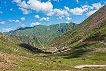
Lhünzhub County is located in central Tibet around 65 km (40 mi) northeast of metropolitan Lhasa. It includes the Pengbo River Valley and the upper reaches of the Lhasa River. It covers an area of 4,512 km2 (1,742 sq mi).[1] The county is geologically complex, with an average elevation of 4,000 metres (13,000 ft). Mineral resources include lead, zinc, copper, silver, gold and gypsum. A spur of the Nyainqêntanglha mountains crosses the whole territory, dividing it into a southern and northern part.[1]
In the south the Pengbo valley has an average elevation of 3,680 metres (12,070 ft) with a mild climate. The average temperature is 5.8 °C (42.4 °F).[1] The northern "three rivers" section, crossed by the Lhasa River and its tributary the Razheng River, is mountainous and has an average elevation of 4,200 metres (13,800 ft). It has average annual temperature of 2.9 °C (37.2 °F) and is mostly pastoral, with yak, sheep and goats. Wildlife includes roe deer, white-lipped deer, otter, black-necked crane, duck, Mongolian gazelle, ibex. Medicinal plants include Cordyceps, Fritillaria, Rhodiola, and Ganoderma lucidum.[1]
Town and townships
The county was established as Lhünzhub Dzong in 1857. In 1959, it merged with Pundo Dzong to form the modern Lhünzhub County. As of 2000 Lhünzhub County has jurisdiction over one town, Lhünzhub, and 9 townships.[2]
- Ganden Chökhor (Lhünzhub) Town (དགའ་ལྡན་ཆོས་འཁོར་, (ལྷུན་གྲུབ་) (甘丹曲果镇)
- Codoi Township (མཚོ་སྟོད་, 春堆乡)
- Karze Township (མཁར་རྩེ་, 卡孜乡)
- Qangka Township (བྱང་ཁ་, 强嘎乡)
- Sumchêng Township (གསུམ་འཕྲེང་, 松盘乡)
- Jangraxa Township (ལྕང་ར་ཤར་, 江热夏乡)
- Banjorling Township (དཔལ་འབྱོར་གླིང་, 边角林乡)
- Pundo Township (ཕུ་མདོ་, 旁多乡)
- Ngarnang Township (ངར་ནང་, 阿朗乡)
- Tanggo Township (ཐང་མགོ་, 唐古乡)
Other settlements
- Zhujia (朱加)
Economy
As of 2000 the county had a total population of 50,895, of which 8,111 lived in a community designated as urban. 2,254 had non-agricultural registration and 48,362 had agricultural registration.[3] The Pengbo valley is the main grain-producing region of Lhasa Municipality and Tibet, with a total of 11,931 hectares (29,480 acres) of arable land.[4] Crops include barley, winter wheat, spring wheat, canola and vegetables such as potato.[5] The total output in 1999 was 57,600 tons of grain.[4]
Livestock includes yak, sheep, goats and horses.[1] Yaks graze at altitudes of 4,300 metres (14,100 ft) or more - higher than is practical with cattle.[6] Crop residues are used for winter and spring feed. In 1996 more than 85% of winter and spring feed was straw, mostly barley straw.[7] Linzhou county has been a leading testing and manufacturing center for frozen yak semen, and a center for selective breeding of yaks.[8] Local enterprises prepare Tibetan medicinal plants and process wood products. Ethnic handicrafts are well developed, including weaving and mats. The Pengbo valley has a long history of pottery-making. Products include braziers, flower pots, vases, jugs and so on.[4]
In 2010 the county had a GDP of 839 million yuan, and government revenue was 26.9 million yuan. Investment in fixed assets was 450 million yuan, excluding water conservancy. The per capita income of farmers and herdsmen was 4,587 yuan.[lower-alpha 1] Mining was an important source of income[lower-alpha 2], and the government had plans to more actively promote tourism.[11]
Infrastructure
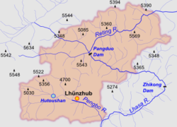
Hutoushan Reservoir lies in Qangka Township. The reservoir is bordered by large swamps and wet meadows, and has abundant plants and shellfish.[12] The Hutuoshan Reservoir in the Pengbo valley is the largest in Tibet, with planned total storage of 12,000,000 cubic metres (420,000,000 cu ft).[13] Endangered Black-necked cranes migrate to the middle and southern part of Tibet every winter, and may be seen on the reservoir.[14]
There is a small hydropower station in Lhünzhub town.[15] The Pangduo Hydro Power Station became operational in 2014. It impounds the Lhasa River in Pondo Township, about 63 kilometres (39 mi) from Lhasa.[16] The reservoir holds 1,170,000,000 cubic metres (4.1×10¹⁰ cu ft) of water.[17] The power station has total installed capacity of 160 MW, with four generating units.[18] It has been called the "Tibetan Three Gorges".[19]
The county has three major highways with total length of 160 kilometres (99 mi) and twelve rural roads, bringing the total road length to over 260 kilometres (160 mi).[4] The county has a radio and television station. TV coverage is received by 72.1% of the population, and radio by 83.4% of the population. The county has 23 health care establishments, including a County People's Hospital with 30 beds. By the end of 2000 there were 122 medical personnel.[4]
Religion
The county is a center of Tibetan Buddhism. There are thirty-seven gompas including twenty-five lamaseries with 919 monks and twelve nunneries with 844 nuns as of 2011. The breakdown by sect is twenty-six Gelug, six Kagyu and five Sakya.[4]
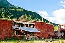
Reting Monastery is located in Lhünzhub County and was built in 1056 by Dromtön (1005–1064), a student of Atiśa. It was the earliest monastery of the Gedain sect, and the patriarchal seat of that sect.[20] In 1240 a Mongol force sacked the monastery and killed 500 people. The gompa was rebuilt. [21] When the Gedain sect joined the Gelug sect in the 16th century the monastery adopted the reincarnation system.[20] The incarnations are named Reting Rimpoche.[22] Following an attempted rebellion against the Lhasa government in 1947 Reting was imprisoned in the Potala. After he died in May 1947 the monastery was looted and then razed.[23] In recent years a lot of reconstruction work has been done. About 160 monks reside in Reting.
References
- ↑ A per capita income of 4,587 yuan converts to US$688 at an exchange rate of 0.15 dollars per yuan.[9]
- ↑ Radio Free Asia reported in 2013 that a Tibetan source had said that since 2005 waste from a mine near Dun village in Kazi Township had been dumped in the local river and pollution of the air had stunted the growth of grass. The source said the miners were almost all Han Chinese.[10]
- 1 2 3 4 5 Linzhou County Profile, LSIIB.
- ↑ Linzhou, Baidu.
- ↑ Yeh & Henderson 2008, pp. 21–25.
- 1 2 3 4 5 6 Linzhou, TibetOL.
- ↑ Linzhou Industry News, LSIIB.
- ↑ Suttie 2003, p. 10.
- ↑ Suttie 2003, p. 169.
- ↑ Bisht 2008, p. 216.
- ↑ XE Currency Table: CNY - Chinese Yuan Renminbi.
- ↑ More Than 80 Trapped in Tibet Gold Mine, RFA.
- ↑ Government Work Report 2011.
- ↑ Lhasa, Tibet Linzhou Hutoushan reservoir is a paradise...
- ↑ Shen 1995, p. 153.
- ↑ Lin 2013.
- ↑ Lhünzhub, Baidu Baike.
- ↑ 'Tibet's Three Gorges Dam' starts operation.
- ↑ Guan 2013.
- ↑ Qin 2013.
- 1 2 Ling 2005, p. 73.
- ↑ McCue 2010, p. 126.
- ↑ Goldstein 1991, p. 187.
- ↑ Kapstein 2013, p. 232.
| Wikimedia Commons has media related to Lhünzhub County. |
Sources
- Bisht, Ramesh Chandra (2008-01-01). International Encyclopaedia Of Himalayas (5 Vols. Set). Mittal Publications. ISBN 978-81-8324-265-3. Retrieved 2015-02-15.
- Goldstein, Melvyn C. (1991-05-19). A History of Modern Tibet, 1913-1951: The Demise of the Lamaist State. University of California Press. ISBN 978-0-520-91176-5. Retrieved 2015-02-15.
- "Government Work Report". Linzhou People's Government Office. 2011-03-21. Retrieved 2015-02-15.
- Guan, Steve (2013-12-12). "Tibet commences new hydropower plant". China Coal Resource. Retrieved 2015-02-06.
- Kapstein, Matthew T. (2013-06-05). The Tibetans. John Wiley & Sons. ISBN 1-118-72537-9. Retrieved 2015-02-15.
- "Lhasa, Tibet Linzhou Hutoushan reservoir is a paradise for photographers". Tibet Travel Web (in Chinese). Retrieved 2015-02-13.
- "Lhünzhub (甘丹曲果镇)". Baidu Baike (in Chinese). Baidu. Retrieved 2015-02-13.
- Lin, Karen (2013-12-12). "Black-Necked Cranes Flocking Back to Tibet". China Tibet Online. Retrieved 2015-02-13.
- Ling, Haicheng (2005). Buddhism in China. 五洲传播出版社. ISBN 978-7-5085-0840-5. Retrieved 2015-02-15.
- "Linzhou (林周县)". Baidu (in Chinese). Retrieved 2015-02-06.
- "Linzhou County Profile". Lhasa Municipal Bureau of Industry and Information. 2011-06-22. Retrieved 2014-02-15.
- "Linzhou Industry News". Lhasa Municipal Bureau of Industry and Information. 2011-06-22. Retrieved 2015-02-15.
- "Linzhou". TibetOL. China Intercontinental Communication Center. Retrieved 2015-02-15.
- McCue, Gary (2010). Trekking in Tibet: A Traveler's Guide. The Mountaineers Books. ISBN 978-1-59485-411-8. Retrieved 2015-02-15.
- "More Than 80 Trapped in Tibet Gold Mine Landslide". Radio Free Asia. 2013-03-29. Retrieved 2015-02-15.
- Qin, Julia (2013-05-10). "Tibet key water-control project to be completed". China Tibet Online. Retrieved 2015-02-05.
- Shen, Dajun (July 1995). "Research on the rational use of water resources on the Lhasa River, Tibet" (PDF). Modelling and Management of Sustainable Basin-scale Water Resource Systems (Proceedings of a Boulder Symposium. IAHS. Archived from the original (PDF) on 2015-02-13. Retrieved 2015-02-13.
- Suttie, J. M. (2003). Transhumant Grazing Systems in Temperate Asia. Food & Agriculture Org. ISBN 978-92-5-104977-8. Retrieved 2015-02-15.
- "Tibet's biggest water-related project launched". China Tibet Online. 2009-08-06. Retrieved 2015-02-05.
- "'Tibet's Three Gorges Dam' starts operation". China Daily. 2013-12-11. Retrieved 2015-02-05.
- "XE Currency Table: CNY - Chinese Yuan Renminbi". XE. Retrieved 2015-02-16.
- Yeh, Emily T.; Henderson, Mark (December 2008). "Interpreting Urbanization in Tibet". Journal of the International Association of Tibetan Studies. 4. Retrieved 2015-02-12.
Coordinates: 30°21′25″N 91°28′30″E / 30.35694°N 91.47500°E