Yadong County
| Yadong County 亚东县 • གྲོ་མོ་རྫོང་། | |
|---|---|
| County | |
 | |
.png) Location of Yadong County within Tibet Autonomous Region | |
 Yadong County Location in Tibet Autonomous Region | |
| Coordinates: 27°31′9″N 88°58′12″E / 27.51917°N 88.97000°E | |
| Country | China |
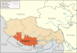
| Province | Tibet Autonomous Region |
| Prefecture-level city | Xigazê |
| Capital | Xarsingma |
| Time zone | UTC+8 (China Standard) |
| Yadong County | |||||||
| Chinese name | |||||||
|---|---|---|---|---|---|---|---|
| Simplified Chinese | 亚东县 | ||||||
| Traditional Chinese | 亞東縣 | ||||||
| |||||||
| Alternative Chinese name | |||||||
| Simplified Chinese | 卓木县 | ||||||
| Traditional Chinese | 卓木縣 | ||||||
| |||||||
| Second alternative Chinese name | |||||||
| Simplified Chinese | 绰莫县 | ||||||
| Traditional Chinese | 綽莫縣 | ||||||
| |||||||
| Tibetan name | |||||||
| Tibetan | གྲོ་མོ་རྫོང༌། | ||||||
| |||||||
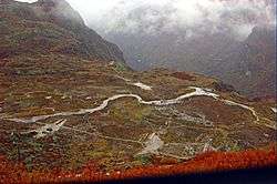
Yadong County (Chinese: 亚东县), also transliterated from Tibetan as Chomo County (Tibetan: གྲོ་མོ་རྫོང༌། ; Chinese: 卓木县 / 绰莫县; literally: "deep ravine county"), is a frontier county and trade-market of Tibet Autonomous Region, China, situated in the mouth of the Chumbi valley near the China-India and China-Bhutan border. It lies in the middle part of Himalayas and the south of Tibet Autonomous Region, covering about 4,306 square kilometers with a population of 10,000. It is under the jurisdiction of Xigazê.
Geography
The town of Dromo (Yadong) Coordinates: 27°29′22″N 88°54′21″E / 27.48944°N 88.90583°E is very close to the borders of both the Indian state of Sikkim and Bhutan and has a hotel, a guest house, some government offices and army barracks.[1]
Local specialities include Dromo fish and barley wine while the main tourist sites are Donggar Monastery, Garju Monastery and Kangbu Hotspring. Yadong is connected to the Indian state of Sikkim via the Nathu La.
As part of the China Western Development strategy, the Chinese government planned to extend the Qinghai–Tibet Railway from Lhasa to Yadong near the Nathu La that marks the disputed China–India border.[2]
History
According to the Convention of Calcutta of 1890–94 signed by Great Britain and Qing dynasty China, the market at Dromo was opened to India. At that time there was a wall-like structure across the valley's stream extending part way up each side of the valley thus blocking the road to the Tibetan capital, Lhasa. This was the demarcation line that British subjects were forbidden to cross and was manned by 20 Tibetan soldiers under a sergeant along with three Chinese officials.[3] The construction of the wall was reported to be one of the incidents that led to the British invasion of Tibet in 1904. According to the resulting Treaty of Lhasa, a British trade-agent was to be stationed at Yadong.[4]
Towns and townships
References
- ↑ Buckley, Michael and Strauss, Robert. Tibet: a travel survival kit, p. 163. (1986) Lonely Planet Publications, Victoria, Australia. ISBN 0-908086-88-1.
- ↑ Extension plans. Retrieved June 28, 2006
- ↑ Sandberg, Graham. An Itinerary of the Route from Sikkim to Lhasa. Calcutta: Baptist Mission Press. p. 7.
- ↑

| County-level divisions |
|  | ||||
|---|---|---|---|---|---|---|
| Settlements | ||||||
| Landmarks | ||||||
| Geography | ||||||
| Transport |
| |||||