Rinbung County
| Rinbung County 仁布县 • རིན་སྤུངས་རྫོང་། | |
|---|---|
| County | |
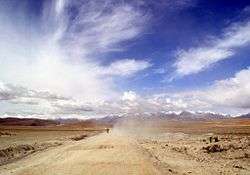 On the road from Lhasa to Gyantse. | |
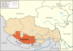
.png) Location of Rinbung County within Tibet | |
 Rinbung County Location in Tibet | |
| Coordinates: 29°6′43″N 90°6′42″E / 29.11194°N 90.11167°ECoordinates: 29°6′43″N 90°6′42″E / 29.11194°N 90.11167°E | |
| Country | China |
| Province | Tibet |
| Prefecture-level city | Xigazê |
| Time zone | UTC+8 (China Standard) |
Rinbung County (Chinese: 仁布县; Pinyin: Rénbù Xiàn) is a county at the northeastern boundary of Xigazê in the Tibet Autonomous Region.
Town and townships
- Dê'gyiling Town (བདེ་སྐྱིད་གླིང་, 德吉林镇)
- Chagba Township (བྲག་པ་, 查巴乡)
- Kangxung Township (ཁང་གཞུང་, 康雄乡)
- Moin Township (སྨོན་, 母乡)
- Bartang Township (བར་ཐང་, 帕当乡)
- Pusum Township (ཕུ་གསུམ་, 普松乡)
- Qewa Township (བྱེ་བ་, 切娃乡)
- Ramba Township (རམ་པ་, 然巴乡)
- Rinbung Township (རིན་སྤུངས་, 仁布乡)
| County-level divisions |
|  | ||||
|---|---|---|---|---|---|---|
| Settlements | ||||||
| Landmarks | ||||||
| Geography | ||||||
| Transport |
| |||||
This article is issued from
Wikipedia.
The text is licensed under Creative Commons - Attribution - Sharealike.
Additional terms may apply for the media files.