Nagqu
| Nagqu 那曲市 ནག་ཆུ་གྲོང་ཁྱེར། | |
|---|---|
| Prefecture-level city | |
.jpg) Nagqu | |
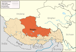 Nagqu (orange) in Tibet Autonomous Region (light-orange) | |
| Coordinates: Coordinates: 31°28′34″N 92°03′05″E / 31.4761110289°N 92.0513207015°E | |
| Country | People's Republic of China |
| Province | Tibet |
| County-level divisions | a district and 10 counties |
| City seat | Seni District |
| Area | |
| • Total | 450,537 km2 (173,953 sq mi) |
| Population (2010)[1] | |
| • Total | 462,381 |
| • Density | 1.0/km2 (2.7/sq mi) |
| Time zone | UTC+8 (China Standard) |
| ISO 3166 code | CN-XZ-06 |
| Website |
www |
| Nagqu | |||||||
| Chinese name | |||||||
|---|---|---|---|---|---|---|---|
| Chinese | 那曲 | ||||||
| Hanyu Pinyin | Nàqū | ||||||
| |||||||
| Alternative Chinese name | |||||||
| Chinese | 黑河 | ||||||
| Hanyu Pinyin | Hēihé | ||||||
| |||||||
| Tibetan name | |||||||
| Tibetan | ནག་ཆུ། | ||||||
| |||||||
Nagqu (also Naqu or Nagchu; Tibetan: ནག་ཆུ།, Wylie: Nag-chu ; Chinese: 那曲; literally: "black river") is a prefecture-level city in the Chinese Autonomous region of Tibet. The former Nagqu Prefecture ceased to be as a separted prefecture, the prefecture-level city of Nagqu was approved to establish by the State Council on October 2, 2017[2][3][4] and officially established on May 7, 2018.[5] Nagqu is the sixth prefecture-level city in Tibet after Lhasa, Shigatse, Chamdo, Nyingchi and Shannan, and it is also the prefecture-level city with the highest altitude.[2]
The prefecture-level city of Nagqu is located in the northeast of Tibet, it is bordered by Bayingolin and Hotan Prefectures of Xinjiang to the north, Haixi, Yushu Prefectures of Qinghai and Chamdo to the east, Nyingchi, Lhasa and Shigatse to the south, Ngari Prefecture to the west. it covers an area of 450,537 km2 (173,953 sq mi) with a population of 462,381 (as of 2010 census[1]).
Nagqu Dagring Airport will be the world's highest altitude airport by 2011 at 4,436 m (14,554 ft) above sea level.[6] Nagqu was chosen to host the largest logistics center in the plateau region, which began operations in August 2009. Nagqu is also on the Qinghai–Tibet railway line. It is expected to become the center of an economic hub in the plateau region. Nagqu has a population of 400,000.[7]
Etymology
Nagqu was once known as "Heihe" (Chinese: 黑河) which comes from that the Tibetan word means black river. It was named after Nagqu River which is the upper master stream of the Nu River runs through the territory. In the Ming and Qing Dynasties, it was known as "haLa wusu" (transliteration of the "Black River" in Mongolian). In modern times, Nagqu (the area around Nagqu Town) is called "Wurguxiong" (Chinese: 吾尔古雄) or "seruxiangba" (Chinese: 色如襄巴).[1]
History
Nagqu appeared clearly in the earliest historical materials, it was part of the ancient Zhangzhung and it was called Yangtong (羊同) in Chinese historical records. In Tibetan historical records, the place was called "Zhuodai" (卓岱), meaning "nomadic tribe", and the inhabitants here were called "Zhuoba" (卓巴), meaning "nomads"; or "Changba" (羌巴), meaning "northerner"; or "Changri", it means the northern tribe. In the era of the ascendancy of Zhangzhung, as its inhabitants divided their territory into the inner, outer and middle three parts. The modern Nagqu roughly is the territories of middle Zhangzhung and outer Zhangzhung. The dzong architecture of Dangnuoqiong was the center of middle Zhangzhung, it was located round the lake of Tangra Yumco in the southwest of Nagqu. As the Zhangzhung Regime was weakened, its territory shrank to the west.[8]
During the Song Dynasty, Nagqu was called one of the Four Northern Tribes (北方四部落). In 1269, the Mongolian soldiers began to garrison in the northern Tibet, and later the "39 Tribes of Hor" (Standard Tibetan: ཧོར, Chinese: 霍尔) formed Mongolian forces in northern Tibet. In 1731, the Qing Government placed the territory of 39 Tribes under the direct jurisdiction of the Amban.
In 1751, Kanxiang Dzong (坎襄宗) in Nagqu was formed to the direct rule of the Kashag Government, and part of the area was under the jurisdiction of Panchen. Around the Xinhai Revolution, the government of the Kashag Government relegated the region of 39 Tribes to its rule and forcibly took over the Panchen Lama. In 1916, the "Hor Director" (霍尔总管) was established. In 1942, the prefecture of Changchub Chikyab (Standard Tibetan: བྱང་ཆུབ་སྤྱི་ཁྱབ་, Chinese: 绛曲基巧) was formed.
In 1951, the seat of Changchub Chikyab Prefecture was Nagqu (Heihe) Town, the prefecture administered the pasture land to the northern Lhasa and 6 dzongs in Heihe area, the Conference Hall of Panchen Chamber (班禅堪布会议厅) administered Damusajia Dzong (达木萨迦宗). The prefecture of Changchub Chikyab had jurisdiction over 14 dzongs in 1954.
The Preparatory Committee of Tibet Autonomous Region set up Chikyab Office (Chinese: 基巧办事处) in Nagqu in October 1956, The prefecture of Changchub Chikyab was renamed to Heihe in 1959, the prefecture of Heihe was renamed to Nagqu in January 1960, its seat was Heihe County (modern Seni District).[1]
Geography
Nagqu is located on the southern slope of Tanggula Mountains, on the north side of Nyenchen Tanglha Mountains, and on the eastern end of the Changtang Plateau. The territory is continuously distributed in the mountains, divided by numerous lake basins, and lots of lakes are dotted. The average altitude is more than 4,500 meters (14,800 ft) above sea level. The area is cold and oxygen-deficient and has a dry climate. The annual windy days are about 100 days. The annual average temperature is −2.1 °C (28.2 °F). The coldest temperatures can reach minus −40 °C (−40 °F). The annual sunshine hours are more than 2,886 hours. It is relatively warm from May to September in the middle of the year, with an annual rainfall of 400 mm (16 in) or more. Most counties mainly rely on animal husbandry, and few counties are semi-agricultural and semi-animal husbandry areas. Main lines of communication includes the Qinghai-Tibet Railway, the G 109 National Highway, the Nagqu - Chamdo (Chinese: 那曲-昌都公路), and the Nagqu - Shiquanhe (Chinese: 那曲-狮泉河公路) highways.[9]
Natural disasters
Nagqu is located in the northern part of the Tibet. It is affected by monsoon climate, plate geology movements, and complex terrain and other disaster-causing factors, it is a natural disaster-prone, contiguous and frequent region.[8]
Administrative divisions
| Map | ||||||||
|---|---|---|---|---|---|---|---|---|
 | ||||||||
| # | Name | Simplified Chinese | Hanyu Pinyin | Tibetan | Wylie | Population (2010 Census) | Area (km²) | Density (/km²) |
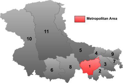
| 1 | Seni District | 色尼区 | Sèní Qū | གསེར་རྙེད་ཆུས། | gser rnyed chus | 108,781 | 16,195 | 6.71 |
| 2 | Lhari County | 嘉黎县 | Jiālí Xiàn | ལྷ་རི་རྫོང་ | lha ri rdzong | 32,356 | 13,056 | 2.47 |
| 3 | Biru County | 比如县 | Bǐrú Xiàn | འབྲི་རུ་རྫོང་ | 'bri ru rdzong | 60,179 | 11,680 | 5.15 |
| 4 | Nyainrong County | 聂荣县 | Nièróng Xiàn | གཉན་རོང་རྫོང་ | gnyan rong rdzong | 32,376 | 9,017 | 3.59 |
| 5 | Amdo County | 安多县 | Ānduō Xiàn | ཨ་མདོ་རྫོང་ | a mdo rdzong | 37,802 | 43,411 | 0.87 |
| 6 | Xainza County | 申扎县 | Shēnzhā Xiàn | ཤན་རྩ་རྫོང་ | shan rtsa rdzong | 20,285 | 25,546 | 0.79 |
| 7 | Sog County | 索县 | Suǒ Xiàn | སོག་རྫོང་ | sog rdzong | 43,621 | 5,744 | 7.59 |
| 8 | Baingoin County | 班戈县 | Bāngē Xiàn | དཔལ་མགོན་རྫོང་ | dpal mgon rdzong | 36,842 | 28,383 | 1.29 |
| 9 | Baqên County | 巴青县 | Bāqīng Xiàn | སྦྲ་ཆེན་རྫོང་ | sbra chen rdzong | 48,284 | 10,326 | 4.67 |
| 10 | Nyima County | 尼玛县 | Nímǎ Xiàn | ཉི་མ་རྫོང་ | nyi ma rdzong | 29,856 | 72,499 | 0.41 |
| 11 | Shuanghu County | 双湖县 | Shuānghú Xiàn | མཚོ་གཉིས་་རྫོང་ | mtsho gnyis rdzong | 11,999 | 116,637 | 0.10 |
Economy
As of 2017, the regional GDP in Nagqu was 11,982 million yuan (1,775 million US dollars), completed fixed assets investment 18,549 million yuan (2,747 million US dollars), urban and rural residents per capita disposable income reached 31,252 yuan (4,629 US dollars), 9,792 yuan (1,450 US dollars), total retail sales of social consumer goods 2,127 million yuan (315 million US dollars), tax revenue exceeded 1,000 million yuan (148 million US dollars).[10]
External links
References
- 1 2 3 4 according to the History of Nagqu Prefecture / 那曲地区历史沿革 see xzqh.org (2016-02-24)
- 1 2 国务院关于同意西藏自治区撤销那曲地区设立地级那曲市的批复 [Official Reply on Approval of the Tibet Autonomous Region to dissolve Nagqu Prefecture and establish the prefecture-level city of Nagqu by the State Council] (in Chinese). Sohu. 2 October 2017.
- ↑ xzali.gov (2018-04-27)
- ↑ ifeng.com (2017-10-02)
- ↑ dzwww.com (2018-05-08) or sohu.com
- ↑ "Travel News, Tips, and Guides - USATODAY.com". USA TODAY. Retrieved 4 October 2017.
- ↑ "Archived copy". Archived from the original on 2010-12-15. Retrieved 2010-12-12.
- 1 2 translated from the encyclopaedia entry of Baike (baidu), see baike (Chinese)
- ↑ Nagqu profile / 那曲地区概况 xzqh.org (2016-02-24)
- ↑ thepaper.cn (2018-04-25)
| District | | |
|---|---|---|
| Counties | ||
| Towns and villages |
| |
| Geography |
| |