Dagze Lake
| Dagze Lake | |
|---|---|
 Satellite picture | |
| Location | Tibet |
| Coordinates | 31°54′N 87°29′E / 31.900°N 87.483°ECoordinates: 31°54′N 87°29′E / 31.900°N 87.483°E |
| Type | meromictic lake[1] |
| Surface area | 260 km2 (100 sq mi) |
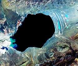
Dagzê Lake (Tibetan: སྟག་རྩེ་མཚོ, ZYPY: Dagzê Co ) is one of many inland lakes in Tibet, with a present area of 260 km² (100 square miles). In glacial times, the region was considerably wetter, and lakes were correspondingly much larger. Changes in climate have resulted in greater aridity on the Tibetan Plateau. The numerous concentric rings that circle the lake are fossil shorelines, and attest to the historical presence of a larger, deeper lake.
See also
Original entry was from the NASA Earth Observatory;
References
- ↑ Wang, M., Hou, J. and Lei, Y., 2014. Classification of Tibetan lakes based on variations in seasonal lake water temperature. Chinese Science Bulletin, 59(34): 4847-4855.
External links
This article is issued from
Wikipedia.
The text is licensed under Creative Commons - Attribution - Sharealike.
Additional terms may apply for the media files.