Amdo County
| Amdo County 安多县 • ཨ་མདོ་རྫོང་། | |
|---|---|
| County | |
 | |
.png) Location of Amdo County within Tibet | |
 Amdo County Location of the seat in Tibet | |
| Coordinates: 32°15′50″N 91°40′50″E / 32.26389°N 91.68056°E | |
| Country | People's Republic of China |
| Autonomous region | Tibet |
| Prefecture-level city | Nagqu |
| Seat | Pagnag |
| Area | |
| • Total | 43,410.85 km2 (16,761.02 sq mi) |
| Population (2000) | |
| • Total | 32,843 |
| Time zone | UTC+8 (China Standard) |
| Amdo County | |||||||||||
| Chinese name | |||||||||||
|---|---|---|---|---|---|---|---|---|---|---|---|
| Simplified Chinese | 安多县 | ||||||||||
| Traditional Chinese | 安多縣 | ||||||||||
| |||||||||||
| Tibetan name | |||||||||||
| Tibetan | ཨ་མདོ་རྫོང་། | ||||||||||
| |||||||||||
Amdo County (Tibetan: ཨ་མདོ་རྫོང་ ; Chinese: 安多县) is a county within Nagqu of the Tibet Autonomous Region of China. The county covers an area of 43,410.85 square kilometres and is dominated by mainly Tibetan grassland. In 2000 it had a population of 32,843 .[1]
Its capital is Amdo Town, north of Lhasa. It has a station on the new railway from Golmud to Lhasa. There is a major rail depot 3 km (1.9 mi) west of the town. Cona Lake lies to the southwest of the town of Amdo.
Administrative divisions
- Zharen Town (ཁྲ་རིང་, 扎仁镇)
- Yanshiping Town (ཡན་ཤིས་ཕིན་, 雁石坪镇)
- Qangma Town (བྱང་མ་, 强玛镇)
- Pana Town (བྲག་ནག་, 帕那镇)
- Cuoma Township (མཚོ་དམར་, 措玛乡)
- Dardü Township (དར་མདུད་, 滩堆乡)
- Sibnak Chenchungo Township (སྲིབ་ནག་ཆེན་ཆུ་མགོ་, 扎曲乡)
- Gangnyi Township (སྐང་གཉིས་, 岗尼乡)
- Marchu Township (དམར་ཆུ་, 玛曲乡)
- Sewu Township (སེའུ་, 色务乡)
- Marrong Township (དམར་རོང་, 玛荣乡)
- Töma Township (སྟོད་མ་, 多玛乡)
- Bangmer Township (སྦང་མེར་, 帮麦乡)
References
| District | 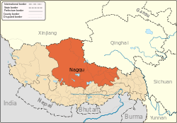 | |
|---|---|---|
| Counties | ||
| Towns and villages |
| |
| Geography |
| |
Coordinates: 32°15′50″N 91°40′50″E / 32.26389°N 91.68056°E
This article is issued from
Wikipedia.
The text is licensed under Creative Commons - Attribution - Sharealike.
Additional terms may apply for the media files.