Dinggyê County
| Dinggyê County 定结县 • གཏིང་སྐྱེས་རྫོང་། | |
|---|---|
| County | |
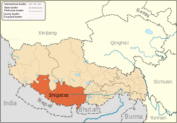
.png) Location of Dinggyê County (red) within Xigazê City (yellow) and the Tibet Autonomous Region | |
 Dinggyê Location of the seat in the Tibet A.R. | |
| Coordinates: 28°22′4″N 87°45′59″E / 28.36778°N 87.76639°ECoordinates: 28°22′4″N 87°45′59″E / 28.36778°N 87.76639°E | |
| Country | People's Republic of China |
| Autonomous region | Tibet Autonomous Region |
| Prefecture-level city | Xigazê |
| Seat | Tingche |
| Time zone | UTC+8 (China Standard) |
| Dinggyê County | |||||||||||
| Chinese name | |||||||||||
|---|---|---|---|---|---|---|---|---|---|---|---|
| Simplified Chinese | 定结县 | ||||||||||
| Traditional Chinese | 定結縣 | ||||||||||
| |||||||||||
| Tibetan name | |||||||||||
| Tibetan | གཏིང་སྐྱེས་རྫོང་། | ||||||||||
| |||||||||||
Dinggyê County or Dinjie County or Tingche County or Tingkye County (Standard Tibetan: གཏིང་སྐྱེས་རྫོང་།, Chinese: 定结县) is a county of the Xigazê in the Tibet Autonomous Region, bordering Nepal's Sankhuwasabha and Taplejung Districts to the south and India's Sikkim state to the southeast. Jin Co and Duolo Co are located in this county.
It is one of the four counties that comprise the Qomolangma National Nature Preserve (Dinggyê, Tingri, Nyalam, and Kyirong).[1]
Towns and townships
- Gyangkar Town (རྒྱལ་མཁར་, 江嘎镇)
- Ri'og Town (རི་འོག་, 日屋镇)
- Chentang Town (འདྲེན་ཐང་, 陈塘镇)
- Gojag Township (ཀོ་ལྕག་, 郭加乡)
- Sar Township (གཟར་, 萨尔乡)
- Kyungzê Township (ཁྱུང་རྩེ་, 琼孜乡)
- Dinggyê Township (གདིང་སྐྱེས་, 定结乡)
- Qab Township (ཆབ་, 确布乡)
- Dozhag Township (རྡོ་བྲག་, 多布扎乡)
- Tashi Nang Township (བཀྲ་ཤིས་སྣང་, 扎西岗乡)
References
- ↑ Department of Forestry, Government of the Tibet Autonomous Region, People’s Republic of China, ‘’Report on Protected Lands in the Tibet Autonomous Region’’ Lhasa: Tibet Autonomous Region Government Publishing House, 2006
| County-level divisions |
|  | ||||
|---|---|---|---|---|---|---|
| Settlements | ||||||
| Landmarks | ||||||
| Geography | ||||||
| Transport |
| |||||
This article is issued from
Wikipedia.
The text is licensed under Creative Commons - Attribution - Sharealike.
Additional terms may apply for the media files.