Pagsum Lake
| Pagsum Co | |
|---|---|
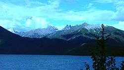 View north-east from Tashi Island | |
| Location | Gongbo'gyamda County, Tibet |
| Coordinates | 30°00′51″N 93°57′01″E / 30.01417°N 93.95028°ECoordinates: 30°00′51″N 93°57′01″E / 30.01417°N 93.95028°E |
| Basin countries | China |
| Max. length | 18 km (11 mi) |
| Surface area | 27 km2 (10 sq mi) |
| Max. depth | 120 m (390 ft) |
| Surface elevation | 3,700 m (12,100 ft) |
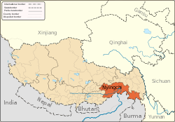
Dragsum Tsho (Tibetan: བྲག་གསུམ་མཚོ་, Wylie: brag gsum mtsho, THL: Draksum Tso , Pagsum Co (simplified Chinese: 八松错; traditional Chinese: 八松錯; pinyin: Bāsōng Cuò), literally meaning “three rocks” in Tibetan,[1] is a lake covering 28 square kilometres in Gongbo'gyamda County, Nyingchi Prefecture of the Tibet Autonomous Region, China, approximately 300 km (190 mi) east of Lhasa. At 3,700 metres over sea level it is about 18 km long and has an average width of approximately 1.5 km (0.93 mi). The deepest point of the green lake measures 120 metres. The lake is also known as Gongga Lake.
Climate
| Climate data for Pagsum Lake | |||||||||||||
|---|---|---|---|---|---|---|---|---|---|---|---|---|---|
| Month | Jan | Feb | Mar | Apr | May | Jun | Jul | Aug | Sep | Oct | Nov | Dec | Year |
| Average high °C (°F) | 5.2 (41.4) |
6.9 (44.4) |
10.3 (50.5) |
13.8 (56.8) |
17.0 (62.6) |
19.7 (67.5) |
20.5 (68.9) |
20.3 (68.5) |
18.4 (65.1) |
14.7 (58.5) |
10.1 (50.2) |
6.6 (43.9) |
13.6 (56.5) |
| Daily mean °C (°F) | −2.4 (27.7) |
−0.1 (31.8) |
3.3 (37.9) |
6.8 (44.2) |
10.4 (50.7) |
13.7 (56.7) |
14.8 (58.6) |
14.4 (57.9) |
12.5 (54.5) |
8.0 (46.4) |
2.6 (36.7) |
−1.1 (30) |
6.9 (44.4) |
| Average low °C (°F) | −10 (14) |
−7.1 (19.2) |
−3.7 (25.3) |
−0.2 (31.6) |
3.8 (38.8) |
7.7 (45.9) |
9.1 (48.4) |
8.5 (47.3) |
6.6 (43.9) |
1.4 (34.5) |
−4.9 (23.2) |
−8.8 (16.2) |
0.2 (32.4) |
| Average precipitation mm (inches) | 2 (0.08) |
3 (0.12) |
10 (0.39) |
27 (1.06) |
51 (2.01) |
108 (4.25) |
117 (4.61) |
100 (3.94) |
89 (3.5) |
28 (1.1) |
5 (0.2) |
2 (0.08) |
542 (21.34) |
| Source: Climate-Data.org | |||||||||||||
Footnotes
- ↑ 国家测绘局地名研究所 (National Surveying and Naming Research Institute) (1995). 西藏地名 / བོད་ལྗོངས་ས་མིང། [Tibetan Place Names]. Beijing: China Tibetology Press (中国藏学出版社). p. 15. ISBN 7-80057-284-6. ; The name is sometimes confused with Basum (Basong Xiang 巴松乡 / dba’ gsum དབའ་གསུམ) in Tingri County of Shigatse Prefecture, due to the similarity of the Chinese names.
This article is issued from
Wikipedia.
The text is licensed under Creative Commons - Attribution - Sharealike.
Additional terms may apply for the media files.