Yarlung Tsangpo Grand Canyon
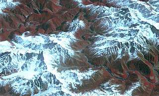


The Yarlung Tsangpo Grand Canyon or Yarlung Zangbo Grand Canyon (Chinese: 雅鲁藏布大峡谷; pinyin: Yǎlǔzàngbù Dàxiágǔ) or simply the Tsangpo Canyon, Brahmaputra Canyon or Tsangpo Gorge, along the Yarlung Tsangpo River in Tibet Autonomous Region, China, is the deepest canyon in the world, and at 504.6 km (314 miles) is slightly longer than the Grand Canyon in the United States, making it one of the world's largest.[1] The Yarlung Tsangpo (Tibetan name for the upper course of the Brahmaputra) originates near Mount Kailash and runs east for about 1700 km, draining a northern section of the Himalayas before it enters the gorge just downstream of Pei, Tibet near the settlement of Zhibe. The canyon has a length of about 240 km (150 miles) as the gorge bends around Mount Namcha Barwa (7782 m) and cuts its way through the eastern Himalayan range. Its waters drop from about 2,900 m near Pei to about 1,500 m at the end of the Upper Gorge where the Po Tsangpo River enters. The river continues through the Lower Gorge to the Indian border at an elevation of 660 m. The river then enters Arunachal Pradesh and eventually becomes the Brahmaputra.[2][3]
Canyon depth
As the canyon passes between the peaks of the Namcha Barwa (Namjabarwa) and Gyala Peri mountains, it reaches an average depth of about 5,000 m (16,000 feet) around Namcha Barwa. The canyon's average depth overall is about 2,268 m (7,440 feet), the deepest depth reaches 6,009 m (19,714 feet). This is the deepest canyon on land. This part of the canyon is at 29°46′11″N 94°59′23″E / 29.769742°N 94.989853°E. Namcha Barwa, 7,782 m (25,531 feet) high, is at 29°37′33″N 95°03′26″E / 29.62583°N 95.05722°E, and Gyala Peri, at 7,234 m (23,733 feet), is at 29°48′48″N 94°58′02″E / 29.81333°N 94.96722°E.[4]
Ecosystem
The gorge has a unique ecosystem with species of animals and plants barely explored and affected by human influence. Its climate ranges from subtropical to Arctic. The highest temperature in Tibet is 43.6 °C (110.5 °F) and is recorded near the border of India at an elevation of approximately 600 meters above sea level. The rare takin is one of the animals hunted by the local tribes.
The Everest of Rivers
Western interest in the Tsangpo began in the 19th century when British explorers and geographers speculated where Tibet's east-flowing Tsangpo ended up, suspecting the Brahmaputra. Since British citizens were not allowed to enter Tibet they recruited Indian “pundits” to do the footwork. Kinthup from Sikkim entered the gorge near Gyala, but it proved to be impenetrable. In 1880 Kinthup was sent back to test the Brahmaputra theory by releasing 500 specially marked logs into the river at a prearranged time. His British boss Captain Henry Harman posted men on the Dihang-Brahmaputra to watch for their arrival. However, Kinthup was sold into slavery, escaped, and ended up employed at a monastery. On three leaves of absence he managed to craft the logs, send a letter from Lhasa with his new intended schedule, and send off the logs. Four years had passed. Unfortunately his note to alert the British got misdirected, his boss had left India, and nobody checked for the appearance of the logs.[5]
In 1913, Frederick Marshman Bailey and Henry Morshead launched an expedition into the gorge that finally confirmed that the Tsangpo was indeed the upper Brahmaputra. Frank Kingdon-Ward started an expedition in 1924 in hopes of finding a major waterfall explaining the difference in altitude between the Tsangpo and the Brahmaputra. It turned out that the gorge has a series of relatively steep sections. Among them was a waterfall he named “Rainbow Falls”, not as big as he had hoped.
The area was closed after China invaded Tibet and disputed the location of the border in the Sino-Indian War. The Chinese government resumed issuing permits in the 1990s. Since then the gorge has also been visited by kayakers. It has been called the “Everest of Rivers” because of the extreme conditions.[6] The first attempt was made in 1993 by a Japanese group who lost one member on the river. In October 1998 an expedition sponsored by the National Geographic Society attempted to kayak the entire gorge. Troubled by unanticipated high water levels, it ended in tragedy when Doug Gordon was lost.[7] In January–February 2002 an international group with Scott Lindgren, Steve Fisher, Mike Abbott, Allan Ellard, Dustin Knapp, and Johnnie and Willie Kern completed the first full descent of the upper Tsangpo gorge section.[8][9]
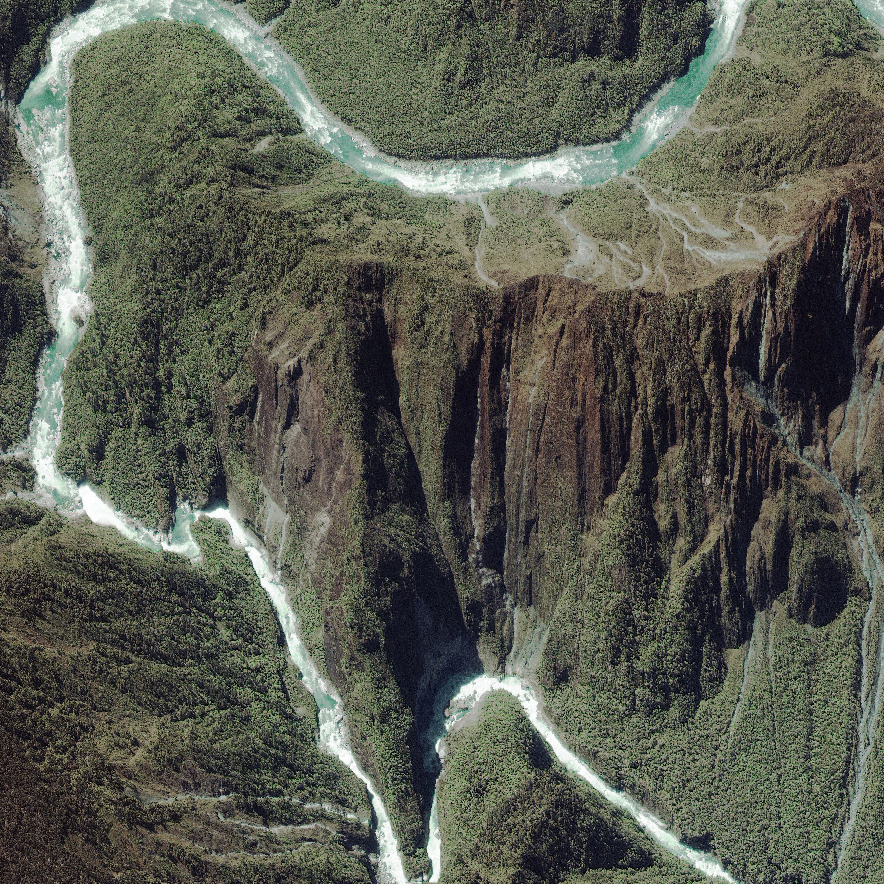
The largest waterfalls of the gorge (near Tsangpo Badong, Chinese: 藏布巴东瀑布群[10]) were visited in 1998, by a team consisting of Ken Storm, Hamid Sarder, Ian Baker and their Monpa guides.[11] They estimated the height of the falls to be about 108 feet (33 m). The falls and rest of the Pemako area are sacred to Tibetan Buddhists who had concealed them from outsiders including the Chinese authorities.[12] In 2005 Chinese National Geography named them China's most beautiful waterfalls.
There are two waterfalls in this section: Rainbow Falls (about 70 feet high) at 29°46′38″N 95°11′00″E / 29.777164°N 95.183406°E and Hidden Falls just downstream at 29°46′34″N 95°10′55″E / 29.776023°N 95.181974°E (about 100 feet high).[4][13]
Yarlung Tsangpo Hydroelectric and Water Diversion Project
While the government of the PRC has declared the establishment of a "Yarlung Tsangpo Grand Canyon National Reservation", there have also been governmental plans and feasibility studies for a major dam to harness hydroelectric power and divert water to other areas in China. The size of the dam in the Tsongpo gorge would exceed that of Three Gorges Dam as it is anticipated that such a plant would generate 50,000 megawatts [14]electricity, more than twice the output of Three Gorges. It is feared that there will be displacement of local populations, destruction of ecosystems, and an impact for downstream people in India and Bangladesh.[15] The project is criticized by India because of its potential negative impact upon the residents downstream.[16]
However, another type of dam, the inflatable, is possible that would obviate any necessity for a huge concrete structure. R.B. Cathcart, in 1999, first suggested a fabric dam—inflatable with freshwater or air—could block the Yarlung Tsangpo Canyon upstream of Namcha Barwa. Water would then be conveyed via a hard rock tunnel to a point downstream from that mountain, affording the generation of tens of thousands of megawatts—power which would have to be distributed internationally and equitably through a Himalayan power grid.[17]
Steel dams are more advantageous and economical in remote hilly terrain at high altitude for diverting the run off water of the river to power generating units.[18][19]
References in media
- The gorges may have helped inspire the idea of Shangri-La in James Hilton's book Lost Horizon in 1933.[20]
- In the fighting game Akatsuki Blitzkampf, the biggest base and research facility of the villainous organization Gessellschaft is hidden in the Yarlung Tsangpo Grand Canyon, referred to in-story as the "Tsangpo Ravine". The second part of the game takes place in said base, with the player fighting their way inside it until they reach the last enemy.
See also
References
- ↑ "china virtual museums_canyon". www.kepu.net.cn. Retrieved 23 April 2018.
- ↑ Yang Qinye and Zheng Du. Tibetan Geography. China Intercontinental Press. pp. 30–31. ISBN 7-5085-0665-0.
- ↑ Zheng Du, Zhang Qingsong, Wu Shaohong: Mountain Geoecology and Sustainable Development of the Tibetan Plateau (Kluwer 2000), ISBN 0-7923-6688-3, p. 312;
- 1 2 "First Descent of the Yarlung Tsangpo in Tibet". www.shangri-la-river-expeditions.com. Archived from the original on 12 September 2016. Retrieved 23 April 2018.
- ↑ Allen, Charles (1982). A Mountain in Tibet: The Search for Mount Kailas and the Sources of the Great Rivers of Asia. London: David & Charles. ISBN 9780233972817.
- ↑ "Press release of successful kayak run". away.com. Archived from the original on 12 August 2009. Retrieved 23 April 2018.
- ↑ Wickliffe W. Walker: "Courting The Diamond Sow : A Whitewater Expedition on Tibet's Forbidden River", National Geographic, 2000
- ↑ Liquid Thunder Archived 2014-04-27 at the Wayback Machine., Outside, June 28, 2004
- ↑ peterswinn (5 June 2011). "First Descents of the Yarlung Tsangpo in Tibet". Archived from the original on 7 March 2016. Retrieved 23 April 2018 – via YouTube.
- ↑ "Archived copy". Archived from the original on 2009-08-12. Retrieved 2009-04-13.
- ↑ Discovery of "Hidden Falls" Archived 2007-09-27 at the Wayback Machine.
- ↑ Ian Baker (2004). The Heart of the World. Penguin Books.
- ↑ The falls can be seen more clearly in an IKONOS image Archived 2011-10-05 at the Wayback Machine. from here Archived 2011-07-16 at the Wayback Machine. taken May 9, 2000, which is oriented with south up.
- ↑ "World's largest hydropower project planned for Tibetan Plateau". www.chinadialogue.net. Archived from the original on 2018-02-28. Retrieved 2017-12-30.
- ↑ "Analysis of Tsangpo Hydroelectric Project, page 21" (PDF). tibetjustice.org. Archived (PDF) from the original on 17 May 2017. Retrieved 23 April 2018.
- ↑ Indian criticism of hydro-dam project Archived 2006-06-21 at the Wayback Machine.
- ↑ R.B. Cathcart, Tibetan Power: A unique hydro-electric macroproject servicing India and China, Current Science 77: 854 (10 October 1999) Archived 2 November 2013 at the Wayback Machine.
- ↑ Terry S. Reynolds. "A Narrow Window of Opportunity: The Rise and Fall of the Fixed Steel Dams". Retrieved 13 April 2014.
- ↑ N. Sasidhar (March 2007). "Fixed steel dams". p. 3. Archived from the original on 17 June 2013. Retrieved 13 April 2013.
- ↑ "Satellite photo and facts". nasa.gov. Archived from the original on 23 April 2018. Retrieved 23 April 2018.
Books
- Wick Walker (2000). Courting the Diamond Sow : A Whitewater Expedition on Tibet's Forbidden River. National Geographic. ISBN 0-7922-7960-3.
- Todd Balf (2001). The Last River : The Tragic Race for Shangri-la. Three Rivers Press. ISBN 0-609-80801-X.
- Michael Mcrae (2002). The Siege of Shangri-La : The Quest for Tibet's Sacred Hidden Paradise. Broadway. ISBN 0-7679-0485-0. ISBN 978-0-7679-0485-8.
- Peter Heller (2004). Hell or High Water : Surviving Tibet's Tsangpo River. Rodale Books. ISBN 1-57954-872-5.
- Ian Baker (2004). The Heart of the World : A journey to the last secret place. Souvenir Press. ISBN 0-285-63742-8.
- F.Kingdon Ward (Author), Kenneth Cox (Editor), Ken Storm Jr (Editor), Ian Baker (Editor) Riddle of the Tsangpo Gorges: Retracing the Epic Journey of 1924–25 in South-East Tibet (Hardcover) Antique Collectors' Club Ltd (1 Jan 1999) ISBN 1-85149-371-9
Videos
- Scott Lindgren (2002), "Into the Tsangpo Gorge". Slproductions. ASIN B0006FKL2Q.
- Into the Tsangpo Gorge Documentary
External links
![]()