Dagzê District
| Dagzê 达孜区 • སྟག་རྩེ་ཆུས། | |
|---|---|
| District | |
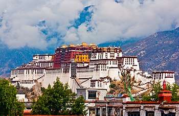
 A view from Ganden Monastery | |
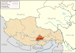
.png) Location of Dagzê District (red) within Lhasa City (yellow) and the Tibet A.R. | |
| Coordinates: 29°40′21″N 91°21′10″E / 29.672447°N 91.352817°ECoordinates: 29°40′21″N 91°21′10″E / 29.672447°N 91.352817°E | |
| Country | People's Republic of China |
| Autonomous region | Tibet |
| Prefecture-level city | Lhasa |
| Seat | Dêqên |
| Area | |
| • Total | 1,373 km2 (530 sq mi) |
| Population (2013) | |
| • Total | 29,152 |
| Time zone | UTC+8 (China Standard) |
| Dagzê | |||||||
| Chinese name | |||||||
|---|---|---|---|---|---|---|---|
| Simplified Chinese | 达孜 | ||||||
| Traditional Chinese | 達孜 | ||||||
| |||||||
| Tibetan name | |||||||
| Tibetan | སྟག་རྩེ་། | ||||||
| |||||||
Dagzê District is a district of Lhasa immediately east of the district of Chengguan, Tibet. The Lhasa River runs through the district. As of 2013 the total population was 29,152, mostly ethnic Tibetans engaged in agriculture. The district is home to the Ganden and Yerpa monasteries.
Location
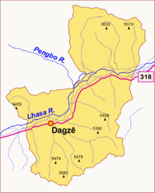
Dazi means "Tiger peak" in Tibetan. It was founded in 1354. Dazi District was established in 1959.[1] The district lies on both sides of the middle reaches of the Lhasa River. It is 20 kilometres (12 mi) to the east of the city of Lhasa in Chengguan District. Zhanang County is to the south, Maizhokunggar County to the east and Linzhou County to the north.[2]
The total area of the district is 1,373 square kilometres (530 sq mi). It has an average elevation of 4,100 metres (13,500 ft) above sea level, and descends from higher ground in the north and south to 3,730 metres (12,240 ft) in the lowest part of the Lhasa river valley.[1] Dazi is in a semi-arid plateau monsoon climate zone. The average temperature is 7.5 °C (45.5 °F), with about 130 days free of frost. Average rainfall is 450 millimetres (18 in).[2] About 80%–90% of precipitation falls in the summer.[3]
Administration
The district includes one town and five townships. The district seat is Dêqên Town, which had a population of 7,382 in 2003. Subdivisions are:[3]
- Dêqên Town (བདེ་ཆེན་, 德庆镇)
- Targyai Township (དར་རྒྱས་, 塔杰乡)
- Zangdog Township (གཙང་ཏོག་, 章多乡)
- Tanggar Township (ཐང་དགར་, 唐嘎乡)
- Xoi Township (ཞོག་མདའ་, 雪乡)
- Dromdoi Township (འབྲོམ་སྟོད།་, 帮堆乡)
People and economy
As of 2013 the total population was 29,152.[1] Most of the people are ethnic Tibetan but there are some Han people and other ethnic minorities.[3] The main occupation is agriculture, including production of wheat, barley, rapeseed, potatoes and other vegetables. Livestock include yaks, cattle, sheep, chickens and ducks. Pigs are also farmed, mainly indoors. As of 2012 per capita income of farmers and herdsmen was 6,740 yuan.[1] A growing amount of fruit and greenhouse-grown organic vegetables, edible mushrooms and medicinal plants is being marketed under the "Dazi Pure" label.[4] As a sideline people make ethnic handicrafts.[2]
Infrastructure
In 2010 there were 28 schools in the county, including one junior high school and one kindergarten, with 276 full-time teachers. There is a district hospital and five township hospitals. The Sichuan-Tibet Highway (China National Highway 318) runs through the county.[2]
The Dazi Bridge, built by the Highway Bureau of Xizang Autonomous Region in 1984, crosses the Lhasa River. It is a steel suspension bridge with a main span of 500 metres (1,600 ft) and a deck width of 4.5 metres (15 ft).[5] In November 2014 it was reported that a new suspension bridge over the Lhasa River linking highway S202 to highway G318 was 80% complete, and would be opened to traffic in 2015. The total length including approaches was 1,400 metres (4,600 ft), with the bridge being 727 metres (2,385 ft) long. The roadbed was 12 metres (39 ft) wide. The total investment was 88 million yuan.[6]
Monasteries
The main monasteries in Dagzê are Ganden Monastery and Yerpa.[3] Gandain monastery was built after 1409 at the initiative of Je Tsongkhapa, founder of the Gelug sect, and is the most important of this sect. It is 57 kilometres (35 mi) from Lhasa on the slopes of Wangbori Mountain at an elevation of 3,800 metres (12,500 ft), on the south bank of the Lhasa River in Dagze County. The mountain is said to have the shape of a reclining elephant. The monastery includes Buddha halls, palace residences, Buddhist colleges and other buildings.[7] Dra Yerpa temple, on a hillside in Dagze County, is known for its meditation cave connected with Songtsän Gampo, the 7th century Tibetan ruler.[8]
 Dazi Bridge over the Lhasa River
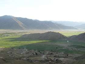 Lhasa River near Ganden Monastery 1
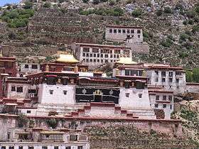 Ganden Monastery
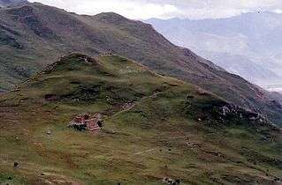 Sky burial site, Yerpa Valley
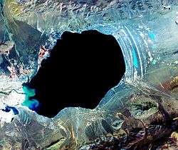 NASA Satellite image of Dagze Co (lake), Tibet
References
| Wikimedia Commons has media related to Dagzê County. |
Sources
- "Basic Dazi". Dazi Industry and Information Bureau. Retrieved 2015-02-21.
- "Dazi". Baidu Baike. Baidu. Retrieved 2015-02-07.
- "Dazi Bridge". Structurae. Retrieved 2015-02-07.
- "Dazi Overview". Dazi county government. 2013-07-10. Retrieved 2015-02-21.
- Gandain Monastery. China Intercontinental Press. 1997. ISBN 978-7-80113-312-0. Retrieved 2015-02-07.
- "Historic Dra Yerpa Temple in Tibet". Global Times. Xinhua. 2012-09-10. Retrieved 2015-02-07.
- Sonam Wangdu (2014-04-03). "Dazi Pure builds healthy fruit and vegetable industry to for high-end boutique market". China Tibet News (in Chinese). Retrieved 2015-02-21.
- Wei (2014-11-06). "Lhasa Dazi new bridge open to traffic next year..." Lhasa Evening News. Retrieved 2015-02-21.