Sri Ganganagar district
| Sri Ganganagar district | |
|---|---|
| District of Rajasthan | |
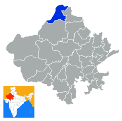 Location of Sri Ganganagar district in Rajasthan | |
| Country | India |
| State | Rajasthan |
| Administrative division | Bikaner Division |
| Headquarters | Sri Ganganagar |
| Tehsils |
Sri Ganganagar Sri Karanpur Sadulshahar Padampur Raisinghnagar Suratgarh Anoopgarh Shri Vijaynagar Gharsana |
| Area | |
| • Total | 11,154 km2 (4,307 sq mi) |
| Population (2011) | |
| • Total | 1,969,520[1] |
| Demographics | |
| • Literacy | 69.6 |
| • Sex ratio | 887 |
| Major highways | NH 15 |
| Website | Official website |
Sri Ganganagar district is a northernmost district of Rajasthan state in western India.
History
Named after Maharaja Ganga Singh of Bikaner, Sri Ganganagar district was part of Bikaner state. This was a mostly uninhabited region. The history of this district is testimony to the vision and efforts of Maharaja Ganga Singh, who visualised and built the Gang Canal after the Indian famine of 1899–1900. The waters of the Sutlej River were brought into the region through the 89-mile long Gang Canal in 1927, turning this region into a breadbasket[2] of Rajasthan.
Geography
Location and area
Sri Ganganagar District is located between Latitude 28.4 to 30.6 and Longitude 72.2 to 75.3[3] The total area of Sri Ganganagar is 11,154.66 km² or 1,115,466 hectares. It is surrounded on the east by Hanumangarh District, (Hanumangarh district was carved out of it on 12 July 1994) on the south by Bikaner District, and on the west by Bahawalnagar district of the Pakistani Punjab and on the north by the Punjab.
Tehsils and other towns
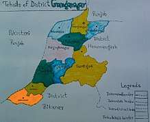
Ganganagar tehsils
There are following ten tehsils in Ganganagar district.
- Sri Ganganagar
- Sri Karanpur, headquarters in the town of Karanpur
- Sadulshahar
- Padampur
- Raisinghnagar
- Suratgarh
- Anoopgarh
- Shri Vijaynagar
- Gharsana
- Rawla Mandi
Demographics
According to the 2011 census Sri Ganganagar district has a population of 1,969,520,[4] roughly equal to the nation of Slovenia[5] or the US state of New Mexico.[6] This gives it a ranking of 235th in India (out of a total of 640).[4] The district has a population density of 179 inhabitants per square kilometre (460/sq mi) .[4] Its population growth rate over the decade 2001-2011 was 10.06%.[4] Ganganagar has a sex ratio of 887 females for every 1000 males,[4] and a literacy rate of 70.25%.[4]
Religion
Media
The district has editions of state level newspapers from Jaipur, which are re-published from Ganganagar and Raisinghnagar. The newspaper Seema Sandesh is published from Ganganagar in Hindi.[8]
"Air Suratgarh", a radio station, broadcasts programmes in Hindi, Rajasthani and Punjabi languages. It was commissioned in 1981 and broadcasts on the 918 kHz frequency.[9]
References
- ↑ "Name Census 2011, Rajasthan data" (PDF). censusindia.gov.in. 2012. Retrieved 28 Feb 2012.
- ↑ Garg, Balwant (27 July 2003). "Suicide woes fill the 'food basket'". The Times Of India.
- ↑ http://ganganagar.nic.in/
- 1 2 3 4 5 6 "District Census 2011". Census2011.co.in. 2011. Retrieved 2011-09-30.
- ↑ US Directorate of Intelligence. "Country Comparison:Population". Retrieved 2011-10-01.
Slovenia 2,000,092 July 2011 est.
- ↑ "2010 Resident Population Data". U. S. Census Bureau. Retrieved 2011-09-30.
New Mexico - 2,059,179
- ↑ "Ganganagar (Sri Ganganagar) District : Census 2011 data". Census 2011. Retrieved 25 September 2018.
- ↑ "Seema Sandesh".
- ↑ "Air Suratgarh". All India Radio.
External links
Places adjacent to Sri Ganganagar district | ||||||||||
|---|---|---|---|---|---|---|---|---|---|---|
| ||||||||||
| Outline |  | ||||||||||||||
|---|---|---|---|---|---|---|---|---|---|---|---|---|---|---|---|
| Governance | |||||||||||||||
| Divisions and districts |
| ||||||||||||||
| Major cities | |||||||||||||||
| Related templates |
| ||||||||||||||
Coordinates: 29°55′04″N 73°52′54″E / 29.91778°N 73.88167°E