Bikaner district
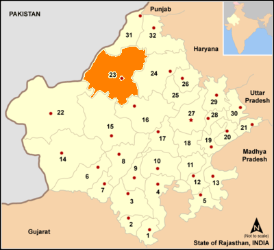
Bikaner District is a district of the state of Rajasthan in western India. The historic city of Bikaner is the district headquarters. Bikaner is also Division with the four district: Bikaner, Churu, Sri Ganganagar and Hanumangarh.
Geography
The district is bounded by Ganganagar District to the north, Hanumangarh District to the northeast, Churu District to the east, Nagaur District to the southeast, Jodhpur District to the south, Jaisalmer District to the southwest, and Punjab Province of Pakistan to the northwest.
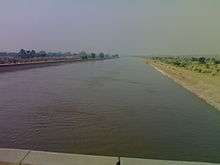
Bikaner District lies in the Thar Desert. The Indira Gandhi Canal, also known as the Rajasthan Canal, runs through the district from northeast to southwest, providing irrigation water for the district. World-famous miracle temple of Karnimata in Deshnok near Bikaner also known as the Temple of Rats.
Climate
| Climate data for Bikaner | |||||||||||||
|---|---|---|---|---|---|---|---|---|---|---|---|---|---|
| Month | Jan | Feb | Mar | Apr | May | Jun | Jul | Aug | Sep | Oct | Nov | Dec | Year |
| Average high °C (°F) | 23.0 (73.4) |
25.5 (77.9) |
31.8 (89.2) |
38.2 (100.8) |
41.7 (107.1) |
41.6 (106.9) |
37.8 (100) |
36.6 (97.9) |
36.7 (98.1) |
36.2 (97.2) |
30.7 (87.3) |
25.3 (77.5) |
33.8 (92.8) |
| Average low °C (°F) | 5.6 (42.1) |
8.8 (47.8) |
15.0 (59) |
22.1 (71.8) |
26.8 (80.2) |
28.8 (83.8) |
27.7 (81.9) |
26.8 (80.2) |
24.7 (76.5) |
19.1 (66.4) |
12.1 (53.8) |
6.9 (44.4) |
18.7 (65.7) |
| Average precipitation mm (inches) | 5 (0.2) |
7 (0.28) |
10 (0.39) |
7 (0.28) |
31 (1.22) |
46 (1.81) |
106 (4.17) |
71 (2.8) |
34 (1.34) |
4 (0.16) |
3 (0.12) |
1 (0.04) |
325 (12.81) |
| Average precipitation days | 0.8 | 1.0 | 1.5 | 0.9 | 2.6 | 3.2 | 6.6 | 5.6 | 3.0 | 0.6 | 0.3 | 0.5 | 26.6 |
| Source: HKO | |||||||||||||
Administrative set-up
Bikaner district has eight sub-divisions called tehsils : Bikaner, Nokha, Loonkaransar, Khajuwala, Shri Dungargarh, Kolayat, Chhattargarh and Pugal. There are two sub tehsils of which Bajju is in Kolayat and Mahajan is in Loonkaransar.
There are 1498 villages and 290 Gram panchayats.[1] There is one Municipal Corporation (Bikaner) and six Municipal Councils :- Deshnok, Nokha, Dungargarh, Khajuwala, Loonkaransar and Napasar. The present Collector of Bikaner is Sh.Ved Prakash IAS.
Demographics
According to the 2011 census Bikaner district has a population of 2,367,745, roughly equal to the nation of Latvia or the US state of New Mexico.[2][3][4] This gives it a ranking of 190th in India (out of a total of 640). Area of district is 30247.90 sq.km. The district has a population density of 78 inhabitants per square kilometre (200/sq mi). Its population growth rate over the decade 2001-2011 was 41.42%. Bikaner has a sex ratio of 903 females for every 1,000 males, and a literacy rate of 65.92%.[2]
See also
References
- ↑ Bikaner-Rajasthan. "Blocks/ Tehsils/ Panchayats". bikaner.rajasthan.gov.in. Retrieved 2016-09-06.
- 1 2 "District Census 2011". Census2011.co.in. 2011. Retrieved 2011-09-30.
- ↑ US Directorate of Intelligence. "Country Comparison:Population". Retrieved 2011-10-01.
Latvia 2,204,708 July 2011 est.
- ↑ "2010 Resident Population Data". U. S. Census Bureau. Archived from the original on January 1, 2011. Retrieved 2011-09-30.
New Mexico - 2,059,179
External links
Places adjacent to Bikaner district | |
|---|---|
| Outline |  | ||||||||||||||
|---|---|---|---|---|---|---|---|---|---|---|---|---|---|---|---|
| Governance | |||||||||||||||
| Divisions and districts |
| ||||||||||||||
| Major cities | |||||||||||||||
| Related templates |
| ||||||||||||||
Coordinates: 28°01′00″N 73°18′00″E / 28.0167°N 73.3°E