Viratnagar
| Bairat Viratnagar | |
|---|---|
| town | |
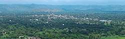 City of Bairat/Viratnagar as seen from Bairat Temple. | |
 Bairat  Bairat | |
| Coordinates: 27°25′59″N 76°10′54″E / 27.433189°N 76.181591°ECoordinates: 27°25′59″N 76°10′54″E / 27.433189°N 76.181591°E | |
| Country | India |
| State | Rajasthan |
| District | Jaipur |
| Elevation | 430 m (1,410 ft) |
| Population (2001) | |
| • Total | 17,237 |
| Languages | |
| • Official | Hindi |
| Time zone | UTC+5:30 (IST) |
| ISO 3166 code | RJ-IN |
| Website | http://www.viratnagar.in |
Bairat (ancient Viratnagar) is a town in northern Jaipur district of Rajasthan, India. It is located 52 km north of Jaipur, and 66 km west of Alwar.
History
Bairat was a part of the Mauryan Empire. The ruins of the Bijak-ki-pahadi (Bairat Temple), a Buddhist Chaitya (chapel) from the 3rd century BCE located in Bairat, are the oldest free-standing Buddhist structures in India.[1] The town is also home to ruins of a Buddhist monastery,[2] a wood and timber shrine, and two rock-cut edicts (Bairat Edict and Bhabru Edict) from Emperor Ashoka; these date from the Mauryan period (circa 250 BCE). However, Akhnoor, a town in the state of Jammu and Kashmir is also considered by many as the ancient Virat Nagar.[3][4]
The town has a number of Mughal structures, including a Chhatri (cenotaph) with some of the earliest surviving murals in Rajasthan, and a lodge where the Mughal emperor Akbar hunted and stayed overnight on his yearly pilgrimage to Ajmer.[5]
The town's Viratnagar Museum houses artifacts from Bairat's long history, including sculptures, coins, pottery, seals and metal objects.
The town was once a thriving Buddhist center of learning and civilization as evidenced by the Buddhist stupa sites found on the hills close by.
The town is home to the 16th century Keshav Rai temple.
Viratnagar%2CRajasthan._01.JPG) The "Bairat Edict" of Ashoka, located in the hills north of Bairat.
The "Bairat Edict" of Ashoka, located in the hills north of Bairat. The Bairat Minor Rock Edict
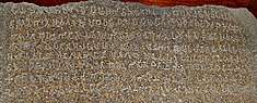 The "Bhabru Edict" of Ashoka, originally located next to Bairat Temple, in the hills southwest of Bairat.
 Remains of the Bairat Temple.
Geography
Bairat is located at 27°27′N 76°11′E / 27.45°N 76.18°E.[6] It has an average elevation of 430 m (1,410 ft).
The Banganga River originates from a nearby village, Mair.
Strange Stone formations
Bairat has some very strange and naturally formed rocks and boulders which resemble animals or human skulls. More research may be needed to determine if there is no human intervention in creating the same.
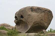 Natural stone formation in the shape of a massive human skull with an exaggerated brain case.
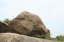 The natural rock formation resembling an elephant head
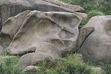 Natural Rock formation in shape of paw or leg impression
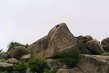 Natural stone formation in the shape of a massive eagle head
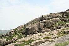 The landscape shows so many skull like features formed naturally
Demographics
At the 2001 census, Viratnagar had a population of 17,237. Males constituted 53% of the population and females 47%. Bairat had an average literacy rate of 50%, lower than the national average of 59.5%; male literacy was 65%, and female literacy was 34%. 20% of the population was under 6 years of age.[7]
References
- ↑ Viratnagar in archives & archaeology: India's perennial city, Sī. Ela Śarmā, Malti Prakashan, 1997
- ↑ A Tryst with History at Viratnagar, Florine Roche, 3 December 2012, http://www.daijiworld.com/chan/exclusive_arch.asp?ex_id=1968
- ↑ Brara, Sarita (10 August 2013). "Akhnoor: Caught in a time warp". The Hindu. Retrieved 29 July 2018.
- ↑ Official Web Site of Akhnoor Sub-Division (J&K)
- ↑ The Early Rajput Murals of Bairat (c. AD 1587) H. Goetz, Ars Orientalis Vol. 1, (1954), pp. 113-118
- ↑ "Falling Rain Genomics, Inc - Bairat". Fallingrain.com. Retrieved 2012-06-05.
- ↑ "Census of India 2001: Data from the 2001 Census, including cities, villages and towns (Provisional)". Census Commission of India. Archived from the original on 2004-06-16. Retrieved 2008-11-01.
| Outline |  | ||||||||||||||
|---|---|---|---|---|---|---|---|---|---|---|---|---|---|---|---|
| Governance | |||||||||||||||
| Divisions and districts |
| ||||||||||||||
| Major cities | |||||||||||||||
| Related templates |
| ||||||||||||||