Sikar district
| Sikar district | |
|---|---|
| District of Rajasthan | |
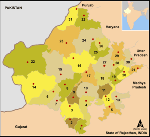
 Location of Sikar district in Rajasthan | |
| Country | India |
| State | Rajasthan |
| Administrative division | Jaipur Division |
| Headquarters | Sikar |
| Tehsils |
|
| Government | |
| • Lok Sabha constituencies | Sikar[1] |
| • Assembly seats |
|
| Area | |
| • Total | 7,742.44 km2 (2,989.37 sq mi) |
| Population (2011) | |
| • Total | 2,677,737[3] |
| • Urban | 633,300 |
| Demographics | |
| • Literacy | 72.98 |
| • Sex ratio | 944 |
| Major highways | NH-11, State Highway 8 |
| Coordinates | 27°13′N 74°26′E / 27.21°N 74.44°E - 28°07′N 75°15′E / 28.12°N 75.25°E |
| Average annual precipitation | 459.8 mm |
| Website | Official website |
Sikar district (Hindi: सीकर जिला) is a district of the Indian state Rajasthan in northern India. The city of Sikar is the administrative headquarters of the district.
Location
The district is located in the north-eastern part of the state of Rajasthan. It is bounded on the north by Jhunjhunu district, in the north-west by Churu district, in the south-west by Nagaur district and in the south-east by Jaipur district. It also touches Mahendragarh district of Haryana on its north-east corner.
The district has an area of 7742.44 km² and a population of 26,77,737 (2011 census). Sikar, Churu district and Jhunjhunu district's comprise the Shekhawati region of Rajasthan. The old name of Sikar was "Veer Bhan Ka Bas".
| Longitude | 74.44 degree to 75.25 degree |
| Latitude | East 27.21 degree to 28.12 degree North |
Demographics
According to the 2011 census Sikar district has a population of 2,677,737,[4] roughly equal to the nation of Kuwait[5] or the US state of Nevada.[6] This gives it a ranking of 150th in India (out of a total of 640).[4] The district has a population density of 346 inhabitants per square kilometre (900/sq mi).[4] Its population growth rate over the decade 2001-2011 was 17.04%.[4]
Sikar has a sex ratio of 944 females for every 1000 males,[4] and a literacy rate of 72.98%.[4]
Climate
The district has a hot summer, scanty rainfall, a chilly winter season and a general dryness of the air, except in the brief monsoon season. The maximum and minimum temperatures are 47 to 48 and 1 to 0 degrees Celsius, respectively. The average temperature around the year is about 8 to 35 degrees Celsius. The normal rainfall, mostly received from the southwest monsoon, is 459.8 mm.
Places of interest
This district is popular as a pilgrimage place of Khatushyam, an avatar of Krishna. Every month before the full moon on Ekadhasi-Dwadasi Tithis a fair is organised. Devotees come from all over the country and other countries, such as Nepal and Bhutan. A big festival takes place every year in the Hindu month of Phagun (February/March) from full moon Navami to Dwadasi as near 20-25 lakhs of people come to celebrate the Darshan of Khatushyam.
- Rajkumar Hardyal Singh Government Museum Sikar, Bada Talab, Sanwali Road
- Jeenmata
- Rewasa
- Harshnath
- Mata Mansa Devi Temple, Hasampur
- Mata Mansa Devi Temple, Dhandhela
- Kankrala Balaji, Sewa
- Salasar Balaji Dham
- Khatushyam
Education
Sikar district has become a hub for education in Rajasthan state. Along with government colleges providing arts, sciences, and commerce education, private educational institutes play a good role in imparting education in the district. Mody Institute of Technology and Science, which is in the Lakshmangarh town of the district imparts girls' education. Other reputed colleges includes Sobhasaria Engineering College.[7] There is one Government Polytechnic College in Sikar district. Here some famous institutes provide coaching for engineering and medical exams. Some institutes are Gurukripa, CLC, Resonance, Career Point, PCP, Samarpan, Matrix,Impulse,BNM Academy. Around 350-400 students were selected in 2013 IIT JEE from these local institutes. Sikar is the smallest city which has IIT JEE Advance centre. Youth men(below 35) provide a major role in Indian defense services compared to other districts of Rajasthan.
Administration
Sub divisions, tehsils, sub tehsils, panchyat samitis and villages
| Total sub divisions | 8 (Sikar, Fatehpur, Laxmangarh, Dantaramgarh, Sri Madhopur, Neem Ka Thana, Dhod, Khandela) |
| Total tehsils | 8 (Sikar, Fatehpur, Laxmangarh, Dantaramgarh, Sri Madhopur, Neem Ka Thana, Dhod, Khandela) |
| Total sub tehsils | 6 (Patan, Palsana, Ajitgarh, Necchawa, Losal, Ramgarh Shekhawati) |
| Blocks (Panchyat Samitis) | 9 (Dhod, Piprali, Fatehpur, Laxmangarh, Dantaramgarh, Sri Madhopur, Khandela, Neem Ka Thana patan) |
| Total villages | 1183 |
Local bodies
| Total Gram Panchayat | 342 |
| Total Nagar-Palika | 8 |
| Total Nagar-Parishad | 1 |
Police
| Total Police-Thana | 23 |
| Police-Chowki | 27 |
| Jails (prisons) | 333 |
Panchayat Committees of Sikar district
Panchayati Raj has decentralized the process of administration at the village level in India. Under this process, a group of villages elect representatives to govern themselves. This group of villages is called Panchayat Samiti. A village or town which is bigger in size is usually chosen as Panchayat Samiti.
Sikar district has nine Panchayat Samitis which includes Dantaramgarh, Dhod, Fatehpur, Khandela, Laxmangarh, Neem ka thana, Piprali, patan and Sri Madhopur. Each Panchayat Samiti is made up villages.[8] Each of the villages have populations ranging from 300 to over 1500.
Dantaramgarh
Dantaramgarh is a constituency of the Rajasthan legislative assembly. Dantaramgarh Panchayat Samiti consists of Aloda, Bai, Bajyawas, Banathala, Banuda, Bharija, Bhima, Bhirana, Chainpura, Chak, Dansroli, Danta, Dhingpur, Dholasari, Dudhwa, Dukiya, Ganoda, Gowati, Jana, Kankara, Karad, Khachariyawas, Khandelsar, Khatu, Khora, Khud, Kochhor, Kuli, Ladpur, Lamiyan, Likhmaka, Manda, Mandha, Mei, Motlawas, Mundiyawas, Pachar, Ralawata, Ramgarh, Reta, Roopgarh, Sami, Shyampur, Sigaliya, Suliyawas, Surera, udaipura villages.
Dhod
Dhod serves as a constituency of the Rajasthan legislative assembly. Dhod Panchayat Samiti consists up of Anokha, Banura Badalwas, Badhadhar, Bhairunpura, Bhuwala, Bidoli, Bijyasi, Bosana, Dhod, Dugoli, Dujod, Fatehpura, Gothda, Gothda, Jerthi, Jhingar, Kanwarpura, Kasli, Khakholi, Kirdoli, Kudan, Ladwa, Losal, Mandawara, Mandota, Morduga, Moondwara, Nagwa,Rooppura, Netarwas, Painwa, Palthana, Purabadi, Puranpura, Rasidpura, Sanwloda, Sewa, Sewad Bari, Sewad Chhoti, Shahpura, Shyampura, Sihot Bari, Singrawat, Sihot Chhoti, Tatanwa.
Fatehpur
Fatehpur is as a constituency of the Rajasthan legislative assembly. Fatehpur Panchayat Samiti consists of Alaphsar, Athwas, Almas (Aalmas). Badusar, Balara, Balod, Banthod, Batdanau, Beswa, Bhaghasran, Bhinchari, Bibipur, Birania, Churimiyan, Dataru, Deenwa-ladkhani, Dewas, Dhandan, Thimoli, Dishnau, Gangyasar, Gaarinda, Godiya, Hirna, Hudera, Kayamsar, Khotiya, Mandela, Nabipura, Nayabas, Palas, Rajas, Rajpura, Rohal, Rosawa, Ramsisar, Sahnusar, Dhakas, Garandawa, Nyagali, Bhakharwasi, Thedi, Lawanda, Takhalsar, Tihawali villages Hudera, Bari, Dhani ridmal ki.
Khandela
Khandela serves as a constituency of the Rajasthan legislative assembly. Khandela Panchayat Samiti consists of Barsinghpura, Basadi, Bawari, Bhadwadi, Burja, Chaukdi, Dayara, Dhalyabas, Dulhepura, Gokulkabas, Govindpura, Hardaskabas, Hathideh, Gurara, Jairampura, Jajod, Jhadli, Jugalpura, Kalyanpura, Kanwat, Kardaka, Kasarda, Kerpura, Khatundara, Kotdi, Lakhani, Pawandaki Dhani, Loharwasa, Gyanpura, Malikpur, Nimeda, Paniharwas, Ralawata, Rampura, Sawaipura, Thikariya, Thoi villages, Thikaria (NH-11).
Laxmangarh
Laxmangarh also serves as constituency of the Rajasthan legislative assembly. Laxmangarh Panchayat Samiti consists of Alakhpura, Bagri, Bathoth. Bhojasar, Bhuma, Bidasar, Birodi Bari, Birodi Chhoti, Bhoodha Ka Bas, Bidsar, Bhilunda (Rulyanapatti) Chhanani, Dehar, Nasanwa, Doodawa, Ganeri, Garoda, Ghana, Ghirniyan, Hameerpura, Jajod, Jasrasar, Kachhwa, Kheriradan, Khinwasar, Khudibadi, Kumas, Lalasi, Manasi, Mangluna, Mirand, Ramsingh Pura, Narodara, Nechhwa, Paldi, Patoda, Olagarh, Rehnawa, Rulyana, Rulyani, Singodara, Suthoth, Sutod, Sigdola Bara, Sigdola Chhota, Tidoki, turkasiya Trilunda villages.diwan ji ka bass Dhanani Punanibatranau (shekhiwas, kandlau, dhani kalyanpura,charanakinau)
Neem Ka thana
Neem ka thana is a constituency of the Rajasthan legislative assembly. Neem ka thana Panchayat Samiti consists of Agwari, Baiwala (consisting Babala and Kakala), Ballupura, Basri, Bega Ka Nangal, Bhagega, Bhudoli, Bihar, Biharipur, Chhaja Ka Nangal, Chala, Charanwas/Pura, Chiplata, Dabla, Dalpatpura, Dariba, Dayal, Deepawas, Dehra, Dhandela, Dokan, Ganeshwar, Gaonri, Ghasipura, Godawas, Govindpura, Guhala, Hasampur, Jhamawas, Jhirana, Jilo, Karjo, Khadra, Kairwali, Keetpura, Khatkar, Kishorpura, Kotra, Kudi, Ladi, Mahawa, Makri, Mandholi, Maonda (kala), Maonda (Khurd), Maonda (R.S.), Modala, Mohanpura (Kharkara), Mokalwas, Mothuka, Narsinghpuri, Natha, Nayabas, Panchu Kharkada, Patan, Pithalpur, Pithampuri, Raipur, Rajpura, Rampura, Ramsinghpura, Salodara, Sanwalpura, Shyampura, Sirohi, Tatera, Teebala, Thikaria, Toda villages.
Piprali
Piprali panchayat samiti consists of Abhaypura, Bajor, Beri, Rajasthan, Bhadwasi, Chainpura, Chandpura, Dadiya, Daulatpura, Gokulpura, Gungara, Gurathda, Harsh, Kishanpura, Kolida, Ktrathal, Kudali, Kushalpura, Lakhipura, Ludhana, Malkeda, Nani, Palasara, Palsana, Piprali, Purohitkabas, Radhakishanpura, Raghunathgarh, Rajpura, Ranoli, Rewasa, Sangarwa, Shishyu, Shyamgarh, Shyampura, Sihasan, Sujawas, Tarpura, Ved Ki Dhani villages, Beri, Balaji Ka Nada.
Sri Madhopur
Sri Madhopur is a constituency of the Rajasthan legislative assembly. Srimadhopur Panchayat Samiti consists of Aabhawas, Aaspura, Ajitgarh, Anantpura, Arniya, Bagariyawas, Bharani, Chomupurohitan, Dadiyarampura, Divrala, Futala, Garhtaknet, Hanspur, Hathora, Jajod, Jaitusar, Jorawar Nagar, Jugrajpura, Kalyanpura, Kanchanpur, Kheri, Kotdi, Kotri Dhaylan, Lampuwa, Lisadiya, Maharoli, Malakali, Mau, Mundaru, Nangal, Nathusar, Patwari ka bas, Reengus, Sargoth, Sihodi, Simarla, Tapiplya, Trilokpura villages.
Infrastructure
Sikar District has a road length of around 2918 km which includes one major National Highway NH-11, state highway 8 and other state highways.(2016-17)
References
- ↑ "Parliamentary Constituencies of Rajasthan" (PDF). 164.100.9.199/home.html. 2012. Archived from the original (PDF) on 2013-06-16. Retrieved 28 Feb 2012.
- ↑ "Assembly Constituencies of Sikar district" (PDF). gisserver1.nic.in/. 2012. Retrieved 28 February 2012.
- ↑ "Name Census 2011, Rajasthan data" (PDF). censusindia.gov.in. 2012. Retrieved 28 Feb 2012.
- 1 2 3 4 5 6 "District Census 2011" (PDF). Census2011.co.in. 2011. Retrieved 2011-09-30.
- ↑ US Directorate of Intelligence. "Country Comparison:Population". Retrieved 2011-10-01.
Kuwait 2,595,62
- ↑ "2010 Resident Population Data". U. S. Census Bureau. Retrieved 2011-09-30.
Nevada 2,700,551
- ↑ Sobhasaria Engineering College Website
- ↑ List of elected sarpanch's in Rajasthan
External links
| Wikimedia Commons has media related to Sikar district. |
- Sikar District web site
- Photo gallery of Sikar
- Amenities Sikar
Places adjacent to Sikar district | |
|---|---|
| Outline |  | ||||||||||||||
|---|---|---|---|---|---|---|---|---|---|---|---|---|---|---|---|
| Governance | |||||||||||||||
| Divisions and districts |
| ||||||||||||||
| Major cities | |||||||||||||||
| Related templates |
| ||||||||||||||