Sri Ganganagar
| Sri Ganganagar | |
|---|---|
| City | |
 Sri Ganganagar Location in Rajasthan, India  Sri Ganganagar Sri Ganganagar (India) | |
| Coordinates: 29°55′N 73°53′E / 29.92°N 73.88°ECoordinates: 29°55′N 73°53′E / 29.92°N 73.88°E | |
| Country |
|
| State | Rajasthan |
| District | Sri Ganganagar |
| Founded by | Maharaja Ganga Singh |
| Named for | Gang Canal |
| Government | |
| • Type | State Government |
| • Body | Government of India |
| Area | |
| • Total | 225 km2 (87 sq mi) |
| Elevation | 178 m (584 ft) |
| Population (2011) | |
| • Total | 254,760 |
| • Density | 1,100/km2 (2,900/sq mi) |
| Languages | |
| • Official | Hindi |
| • Regional | Punjabi, Bagri and Hindi |
| Time zone | UTC+5:30 (IST) |
| PIN | 335001 |
| Telephone code | 0154 |
| ISO 3166 code | RJ-IN |
| Vehicle registration | RJ-13 |
| Sex ratio | 789 ♂/♀ |
| Website | sriganganagar.rajasthan.gov.in |
Sri Ganganagar is a planned city and the northern-most city of the Indian state of Rajasthan, near the borders of Rajasthan and Punjab states and the international border of India and Pakistan. It is the administrative headquarters of Sri Ganganagar district. It is named after Maharaja Shri Ganga Singh Bahadur, Maharaja of Bikaner. It is known as "the food basket of Rajasthan".
History
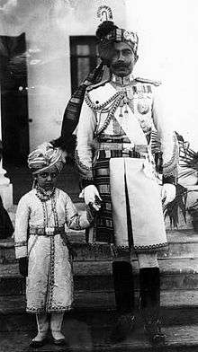
Sri Ganganagar was established by Maharaja Ganga Singh, near Ramanagar which was named Rami Ki Dhani after Ram Singh Saharan and now known as 'Purani Abadi' and 'Old Abadi'. Sri Ganganagar is one of the first well-planned modern cities of India; it is said to be influenced by the town planning of Paris. It is divided into residential blocks and a commercial area which includes Dhan Mandi (agricultural marketplace).
It is at the point where the Sutlej waters enter Rajasthan or the erstwhile Bikaner State. It is said by the elders that this area first came under the erstwhile Bahawalpur state. But, due to the large open area, this was unguarded and Hindu Mal (a companion of Maharaja Ganga Singh) took advantage of this opportunity and changed the boundaries or the posts along the boundary. He started his journey to change posts from Suratgarh in south till Hindumalkot city in north of this district. He informed the Maharaja about his successful invasion of the area when he reached the northern part and thereafter died giving name to the city Hindumalkot.
In 1899-1900, the Bikaner State was affected by a severe famine. To resolve this issue permanently, Maharaja Ganga Singh obtained the services of AWE Standley, chief engineer, who demonstrated the feasibility of the western area of the Bikaner State being brought under irrigation from the Sutlej waters. The plan of the Sutlej Valley Project was drawn by the chief engineer of Punjab, RG Kennedy, according to which the vast area of erstwhile Bikaner State could be brought under irrigation. However, the project got delayed due to objections by the erstwhile State of Bahawalpur.
With the intervention of then Viceroy of India, Lord Curzon, in 1906, a Tripartite Conference was held and an agreement was reached and signed on 4 September 1920. The foundation stone of the Canal Head Works at Ferozepur was laid on 5 December 1925, and the work completed in 1927 by constructing 143 km (89 mi) of lined canal. The opening ceremony was performed on 26 October 1927 by Lord Irwin, the then Viceroy of India.
The plan for the city of Sri Ganganagar was drawn at this time. Irrigated parts of Bikaner State were brought under Sri Ganganagar district and later sub-divided into Hanumangarh district in 1994
Location and area
Sri Ganganagar District is between latitude 28.4 to 30.6 and longitude 72.2 to 75.3[1] The total area of Sri Ganganagar is 11,154.66 km² or 1,115,466 hectares. It is surrounded on the east by Hanumangarh District, (Hanumangarh district was carved out of it on 12 July 1994) on the south by Bikaner District, and on the west by Bahawalnagar district of the Pakistani Punjab and on the north by the Punjab.
Political representation
- Member of Parliament Ganganagar (Lok Sabha constituency): Nihalchand, Bhartiya Janata Party
- Member of Legislative Assembly (Rajasthan): Kamini Jindal, National Unionist Zamindara Party
Topography
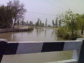
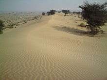
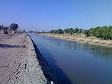
Although Ganganagar District lies in the great Thar desert, irrigation via the Gang Canal and Indira Gandhi Nehar Priyojna has changed the flora and fauna. The district can be classified into five geographical regions:
- The region irrigated by the Gang canal and the Bhakhra canal tributaries: the northern region, which is 3/4 of the district, resembles the fertile plains of Punjab. Some areas, like the area between the towns of Raisinghnagar and Vijaynagar, have desert-like conditions.
- Area irrigated by the Suratgarh branch of the IGNP canal
- Area irrigated by Anupgarh branch of IGNP canal: It comprises Anupgarh and Gharsana tehsils. It is the southernmost region of the district, of which much has been converted into plains, but sandy dunes can be seen.
- The Naali belt: This is a narrow basin of the Ghaggar river. It is the only major river of the district. It is a seasonal river, which flows in the rainy season. It enters the district near Suratgarh and flows in areas of Jaitsar, Vijaynagar, and Anoopgarh, then crosses the Indo-Pakistan border.
- The Uncha Tibba (high sandy dunes) area of Suratgarh tehsil: Large sandy dunes and lack of water predominate here. This area can be said to be a 'real desert'. People of this area face harsh conditions in the desert.
- The Villages in the Area are named after the Canal/water Distributary passing nearby.Example Village-Chak 13'Z',This is the 13th Village on the Z Canal,Chak 4'E',it is the 4th Village on the E Canal/Distributory.
Climate
The climate of Sri Ganganagar varies to extreme limits. Summer temperature reaches 50° Celsius and winter temperature dips just around 0° Celsius.[2] The average annual rainfall is only 200 mm (7.9 in).[3] Average maximum temperature in summer is 41.2 °C and average minimum temperature in winter is 6 °C.
| Climate data for Sri Ganganagar | |||||||||||||
|---|---|---|---|---|---|---|---|---|---|---|---|---|---|
| Month | Jan | Feb | Mar | Apr | May | Jun | Jul | Aug | Sep | Oct | Nov | Dec | Year |
| Record high °C (°F) | 36.1 (97) |
35.0 (95) |
41.6 (106.9) |
47.0 (116.6) |
50.0 (122) |
50.0 (122) |
46.8 (116.2) |
43.4 (110.1) |
43.8 (110.8) |
41.1 (106) |
39.0 (102.2) |
31.5 (88.7) |
50 (122) |
| Average high °C (°F) | 20.9 (69.6) |
23.5 (74.3) |
28.9 (84) |
36.5 (97.7) |
41.0 (105.8) |
41.5 (106.7) |
38.0 (100.4) |
37.1 (98.8) |
36.8 (98.2) |
34.9 (94.8) |
29.4 (84.9) |
23.1 (73.6) |
32.6 (90.7) |
| Average low °C (°F) | 5.8 (42.4) |
8.1 (46.6) |
13.0 (55.4) |
18.9 (66) |
24.3 (75.7) |
27.8 (82) |
27.5 (81.5) |
26.7 (80.1) |
23.9 (75) |
17.3 (63.1) |
11.2 (52.2) |
6.7 (44.1) |
17.6 (63.7) |
| Record low °C (°F) | −2.2 (28) |
−2.8 (27) |
0.6 (33.1) |
6.9 (44.4) |
11.7 (53.1) |
15.8 (60.4) |
14.5 (58.1) |
16.2 (61.2) |
14.0 (57.2) |
6.7 (44.1) |
1.7 (35.1) |
−1.7 (28.9) |
−2.8 (27) |
| Average precipitation mm (inches) | 10.3 (0.406) |
13.6 (0.535) |
8.2 (0.323) |
14.8 (0.583) |
14.6 (0.575) |
36.2 (1.425) |
99.2 (3.906) |
71.5 (2.815) |
38.2 (1.504) |
2.4 (0.094) |
3.6 (0.142) |
3.9 (0.154) |
316.5 (12.462) |
| Source: IMD (extreme high and lows up to 2010) | |||||||||||||
Demographics
According to the 2011 census Sri Ganganagar district has a population of 1,969,520,[5] roughly equal to the nation of Slovenia[6] or the US state of New Mexico.[7] This gives it a ranking of 235th in India (out of a total of 640).[5] The district has a population density of 179 inhabitants per square kilometre (460/sq mi).[5]
Its population growth rate over the decade 2001-2011 was 10.06%.[5] Ganganagar has a sex ratio of 873 females for every 1000 males.[5][5] Males constitute 52.99% of the population and females 47.01%. Ganganagar has an average literacy rate of 70.25%, higher than the national average of 59.8%: male literacy is 79.33%, and female literacy is 60.07%. In Ganganagar, 13% of the population is under 6 years of age. A majority of the population is Hindu, Jain and Sikh. The city has a very significant influence of Punjabi culture because of its proximity to the State of Punjab.
Economy
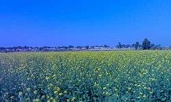
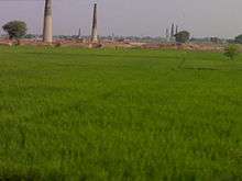
Desert land was converted to a green town by the efforts of Maharaja Ganga Singh, who brought the Gang canal. It carries the excess waters of Punjab and Himachal Pradesh to the region, making Ganganagar a district known as "the food basket of Rajasthan".[8]
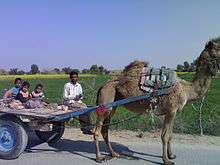
The economy of the city is based on agriculture; its main crops are wheat, mustard and cotton. Other crops are guar, bajra, sugar cane and grams. In recent years, farmers are diverting towards horticulture. Kinnow (a citrus family fruit or a hybrid citrus fruit) is a popular horticultural product; other fruits of the citrus family are also grown.
Industries in Sri Ganganagar District are based on agriculture. Major industries are cotton ginning and pressing factories, mustard oil mills, wheat flour mills, Rajasthan State Ganganagar Sugar Mills (known for its Royal Heritage Liqueurs),[9][10] 20 top renowned industries are Vikas WSP (P) Limited, T.C. Fresh Kinnow Waxing, Kanda Edible Oil Unit, Ruchi Soya Indusjtries etc. It has cotton spinning and textile factories such as JCT Mills (now closed). Most of the factories are in and around Sri Ganganagar City.
Culture
A majority of people in the district speak Punjabi and bagri, too is popular. Writers of the district have made contributions to Rajasthani literature, through Bagri.[11]
Punjabi culture dominates the district, while Bagri culture has influence in some areas.
The embroidered odhni (mostly red) is a symbol of Bagri women. A long shirt and ghaghro (long frock-type clothes) and borlo (a head ornament) is the traditional dress of Bagri women.
The purdah (or veil) is mainly in vogue among Bagri women. Men mainly wear a pant-shirt, kurta-payjama and dhoti.
Traditional and Pop Punjabi music and Rajasthani devotional music is popular. Bollywood songs are listened to with the same enthusiasm as in other northern Indian regions.
Religion
The majority religion here is Hinduism followed by Sikhism due to its proximity with Punjab. The place has Hindu shrines. Sikh shrine Gurudwara Buddha Johad is located here. Islam and Christianity have a presence with a few mosques and churches. Migrants from other states are followers of minority religions.
Tourist attractions
- Historical Gurudwara Buddha Johad: A large gurudwara, 55 km from Ganganagar in the southwest. This is where Bhai Sukha Singh and Mehtab Singh brought the head of Massa Rangarh (guilty of sacrilege of the Amritsar Golden Temple) and hung it on a tree on 11 August 1740.
- Bror Village: Ruins of the Indus Valley Civilisation are found here. It is on Anoopgarh-Ramsinghpur road.
- Dada Pamparam's Dera is at Vijayanagar town, and is the samadhi (tomb) of Baba Pamparam.
- Laila-Majnu ki Mazar (tomb), Binjaur village. Laila Majnu Ki Mazar is 11 km (6.6 mi) from Anoopgarh on the western side. Here is the so-called mazar of Laila-Majnu. It was built in remembrance of mutual devotion and love between a teacher and a student. A fair is held in June.
%2CAnupgarh_Sivender.jpg)
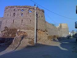
- Anoopgarh Fort is a ruin in the city of Anoopgarh. It was built by Anoop Singh Rathore.
- The Hindumalkot Border, the Indo-Pak Border, derives its name from Hindumal, the Diwan of Bikaner. Pakistan’s Observation Post can be seen from this site.
Temples and places for worship
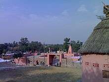
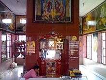
The landscape of Sri Ganganagar is dotted with temples and religious places. The famous temples in Sri Ganganagar include
- Gayatri shaktipeeth is dedicated to maa Gayatri the goddess of vedas. the temple is at g-1-a hanuman nagar.
- Ram Mandir
- The Gauri Shankar Temple is dedicated to Lord Shiva. There is a Shivalinga in the sanctum. It was built using sandstone and has two cone-shaped turrets.
- Siddhi Jhaanki Wale Hanumaan Ji Ka Mandir
- Hanumaan Mandir is dedicated to Hanuman in the heart of the city, in L-Block.
- Balaji Dhaam is on Hanumangarh Road, near the Ridhi Sidhi Enclave. This temple is devoted to Sri Balaji and is surrounded by other temples.
- Durga Mandir dedicated to goddess Durga, surrounded by a crowded market; the area in the evening is crowded by youth.
- Rojhri Dham is a complex of religious sites dedicated to the worship of the Hindu deity Hanuman. Dham attracts many local worshipers throughout the year. On Chaitra Purnima and Ashvin Purnima every year, large jagrans are organized, where thousands of people assemble to pay homage to the deity. Hanuman Sewa Samiti manages the temple and jagarans. The temple of Hanuman is on the right side of Anupgarh-Bikaner road, about one kilometre from Rojhri Village.
- Chanana-Dham (Chanana shrine): A great temple of Lord Hanumanji is here, built in 1971. It is 36 km from district headquarters on the way to Padampur (Tehsil) on bifurcating road at Chunawad town along with GG canal.
In addition to this, religious centres such as Gurudwara Buddha Johad and Shivpuri Kagad are common tourist destinations. Shri Jagadamba Andh-vidhyalaya, one of the largest institutes of India for the education of visually, hearing and speech impaired people is in Sri Ganganagar city.
Transport
Auto rickshaws And Cycle rickshaws are majorly used for internal transport.
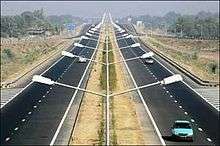
Sri Ganganagar is well connected with road and is linked directly to Delhi, Jaipur, Ludhiana, Chandigarh, Sikar, Karnal, Haridwar, Bathinda, Ambala, Jodhpur and many other cities. Nation Highway 62 passes through Sri Ganganagar. Sri Ganganagr is directly connected to Delhi, Jaipur, Kota, Bikaner, Hanumangarh , Jodhpur , Ambala, Haridwar, Firozpur, Howrah, Trichy , Nanded , Ahmedabad , Pune , Roorkee , Kanpur and some other cities via train.
Lalgarh Airport served by Supreme Airlines has twice a day scheduled services to State capital Jaipur from Sri Ganganagar.[12] The next nearest airport is Bathinda Airport which has flights to New Delhi. The nearest International airports are Sri Guru Ram Dass Jee International Airport in Amritsar and Chandigarh International Airport which is 348 Km from Sri Ganganagar.
Tehsils and other towns
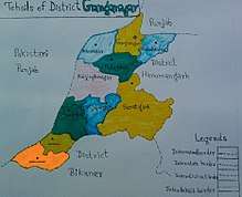
Ganganagar tehsils
There are ten tehsils in Ganganagar district.
Other major towns and villages
Raisinghnagar, Kesrisinghpur, Gajsinghpur, Suratgarh, Ramsinghpur, Jaitsar, Rawla Mandi are major towns, whereas Raghunathpura, Lalgarh Jatan, Ridmalsar, Kikarwalee, Budhajor, Binjhbayla, Rajiasar, Patroda, Sameja Kothi, Chunawadh, Birmana, Hindumalkot, Zorawar singh pur, Banda colony, Bajuwala, Birmana, Dhaban Jhallar, Khat Sajwar, Mirjawala, Netewala are small towns and villages.
Many towns and cities in Sri Ganganagar District are named after members of the royal family of the former Bikaner State.
Notable People
- Jagjit Singh, Ghazal singer, was born in Sri Ganganagar
- Avtar Singh Cheema, an Arjuna Awardee who was the first Indian to climb Mount Everest
- Kamini Jindal, one of the richest MLA from Rajasthan.
- Shahid Mallya, Bollywood singer
- Ravinder Kaushik, former Research and Analysis Wing agent
- Shyam Rangeela, Comedian.
References
- ↑ "Archived copy". Archived from the original on 19 January 2012. Retrieved 19 January 2012.
- ↑ "Temperature Regimes". Water Resource Department - Government Of Rajasthan. Retrieved 2008-12-06.
- ↑ INDIA METEOROLOGICAL DEPT
- ↑ http://www.census2011.co.in/census/city/64-ganganagar.html
- 1 2 3 4 5 6 "District Census 2011". Census2011.co.in. 2011. Retrieved 2011-09-30.
- ↑ US Directorate of Intelligence. "Country Comparison: Population". Retrieved 2011-10-01.
Slovenia 2,000,092 July 2011 est.
- ↑ "2010 Resident Population Data". U.S. Census Bureau. Retrieved 2011-09-30.
New Mexico - 2,059,179
- ↑ Garg, Balwant (2003-07-27). "Suicide woes fill the 'food basket'". The Times of India. Retrieved 2008-12-06.
- ↑ http://www.royalheritageliqueur.com/
- ↑ http://www.rsgsm.net/default.asp
- ↑ M. Paul Lewis, ed. (2009). "Bagri: A language of India". Ethnologue: Languages of the World (16th ed.). Dallas, Texas: SIL International. Retrieved 2011-09-28.
- ↑ "Aviation: First Jaipur-Sri Ganganagar flight flagged off by Rajasthan CM Raje". Zee Business. Retrieved 15 July 2018.
| Outline |  | ||||||||||||||
|---|---|---|---|---|---|---|---|---|---|---|---|---|---|---|---|
| Governance | |||||||||||||||
| Divisions and districts |
| ||||||||||||||
| Major cities | |||||||||||||||
| Related templates |
| ||||||||||||||