Kotputli
| Kotputli City कोटपूतली शहर | |
|---|---|
| City | |
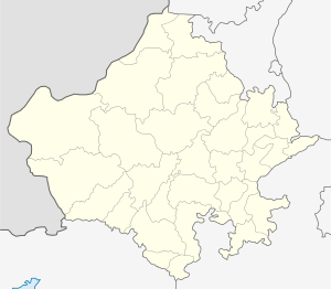
 Kotputli City Location in Rajasthan, India | |
| Coordinates: 27°42′20″N 76°11′27″E / 27.705479°N 76.190969°ECoordinates: 27°42′20″N 76°11′27″E / 27.705479°N 76.190969°E | |
| Country |
|
| State | Rajasthan |
| District | Jaipur |
| Tehsil | Kotputli |
| Population (2011) | |
| • Total | 550,734 |
| Languages | |
| • Official | Hindi |
| • Regional | Gurjar |
| Time zone | UTC+5:30 (IST) |
| PIN | 303108 |
| Telephone code | 01421 |
| Vehicle registration | RJ 32 |
Kotputli is a city and a municipality in Jaipur district in the Indian state of Rajasthan.it is the connectivity between Jaipur and Delhi. It is made up of the main town named Kot and the nearby Putli village, both village belongs to Gurjar Samaj, which now considered a part of the main city. Kotputli is a very old and historical place. It was a part of the Matsya ( now Alwar ) kingdom having capital at nearby village Bairath during the period of Mahabharta.
Kotputli have a GURJAR'S history and other Samaj also, During the British period, Kotputli was a nizamat under the princely state of Khetri. Raja Sardar Singh of Khetri constructed many buildings in Kotputli and Govt.Sardar School and Sardar Zanana Hospital made by local Gurjar bodies and morijawala family .and now many schools, hospital are here. Its location is also very good. So here lot of business opportunities and Asia largest birla cement plant and more industries. Its 70 km away from Alwar, 105 km away from Jaipur and 128 km from Gurgaon. Nearby places to visit includes Bhangarh, Siliserh, Baleshwar historic temple (it's 40 km away from city) Baba bhaion temple village Khuhada Sariska, Sarund Mata, etc.
Population
The Kotputli Municipality has population of 49,202 of which 26,051 are males while 23,151 are females as per report released by Census India 2011.
Demographics
As of the 2011 Indian census,[1] Kotputli had a population of 2,75,367. Males constitute 53% of the population and females 47%. Kotputli has an average literacy rate of 67%, higher than the national average of 59.5%: male literacy is 70%, and female literacy is 56%. In Kotputli, 16% of the population is under 16 years of age.
Kotputli Religion Data 2011
| City | No. of Household | Hindu | Muslim | Christian | Sikh | Buddhist | Jain | Others | Not Stated |
|---|---|---|---|---|---|---|---|---|---|
| Kotputli | 46,909 | 97.62% | 2.08% | 0.10% | 0.12% | 0.00% | 0.04% | 0.00% | 0.05% |
Geography and climate
Kotputli is located at 27.705479°N 76.190969°E. It has an average elevation of 439 metres (1440 feet).
| Climate data for Kotputli | |||||||||||||
|---|---|---|---|---|---|---|---|---|---|---|---|---|---|
| Month | Jan | Feb | Mar | Apr | May | Jun | Jul | Aug | Sep | Oct | Nov | Dec | Year |
| Average high °C (°F) | 25 (77) |
28 (82) |
34 (93) |
38 (100) |
41 (106) |
40 (104) |
36 (97) |
34 (93) |
36 (97) |
36 (97) |
31 (88) |
27 (81) |
34 (93) |
| Average low °C (°F) | 8 (46) |
12 (54) |
18 (64) |
23 (73) |
27 (81) |
29 (84) |
27 (81) |
26 (79) |
25 (77) |
20 (68) |
15 (59) |
9 (48) |
20 (68) |
| Average precipitation cm (inches) | 0.35 (0.138) |
0.27 (0.106) |
0.32 (0.126) |
0.35 (0.138) |
0.6 (0.24) |
3.26 (1.283) |
8.89 (3.5) |
6.44 (2.535) |
3.42 (1.346) |
0.45 (0.177) |
0.07 (0.028) |
0.06 (0.024) |
24.48 (9.641) |
| Source: Foreca | |||||||||||||
See also
References
- ↑ "Census of India 2001: Data from the 2001 Census, including cities, villages and towns (Provisional)". Census Commission of India. Archived from the original on 2004-06-16. Retrieved 2008-11-01.
- ↑ Kotputli City Population Census 2011 - Rajasthan. Census2011.co.in. Retrieved on 2018-08-25.