Bali, Rajasthan
| Bali बाली | |
|---|---|
| Town | |
 Prithviraj Chauhan Chauk | |
 Bali Location in Rajasthan, India  Bali Bali (India) | |
| Coordinates: 25°11′N 73°17′E / 25.18°N 73.28°ECoordinates: 25°11′N 73°17′E / 25.18°N 73.28°E | |
| Country |
|
| State | Rajasthan |
| District | Pali |
| Government | |
| • Type | Municipal corporation |
| • Body | Nagar Palika |
| Elevation | 298 m (978 ft) |
| Population (2011) | |
| • Total | 19,880 |
| Languages | |
| • Official | Hindi |
| Time zone | UTC+5:30 (IST) |
| PIN | 306701 |
| Telephone code | 02938 |
| ISO 3166 code | RJ-IN |
| Vehicle registration | RJ-22 |
| Sex ratio | 987 ♂/♀ |
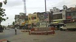
Bali is a town and a municipality in Pali district in the state of Rajasthan, India.
The town is situated on the left bank of the Mithari River. This walled town was the headquarters of a district having the same name in the Jodhpur State. Bali is a tehsil and panchayat samiti with the same name. Bali is also a sub-divisions among the 10 sub-divisions of the Pali district. It is known for its fort. Nearest towns are Falna & Sadri.
History
A dispensary was established in this town in March 1896. In 1897, it served 17 in-patients and 4166 out-patients and 318 operations were performed in it.[1] In 1900 there was a plague outbreak in town and the town was evacuated. 1245 deaths occurred during the month of January 1900 as a result of diarrhoea, dysentery and pneumonia. Prior to formation of Rajasthan it was headquarters of a district with same name in erstwhile Jodhpur state. Bali had its own municipality even before independence. It had a middle school in 1932 that was upgraded to high school and in 1946 had more than 200 pupils. In 1960 Bali had three primary schools for boys, one primary school for girls and a high school. The telephone arrived in Bali in 1957, it got electricity in 1961 and piped water connections were given in 1970. A tehsil library was established in the center of Bali in Bawari Jav in 1958. In addition Bali also has a Jain library. In bali village one of famous sirvi aai mata Hindu temple
Geography
Bali is located at 25°11′N 73°17′E / 25.18°N 73.28°E[2] near the Aravalli Range. It is a constituency of Pali district. It has an average elevation of 298 metres (977 feet). In the easts 7 km from Bali. The nearest airport is Udaipur.
Administration
Bali is represented in the center under Pali (Lok Sabha constituency), while in state it is represented under the Bali (Rajasthan Assembly constituency). Present MLA is Mr. Pushpendra Singh Ranawat. It is a municipality of class IV. There are 20 wards for the municipality. Presently Bali has BJP board and Chairperson is Mr. Lakhmaram Choudhary.
Demographics
As of 2011 India census,[3] Bali had a population of 19,880. Males constitute 50.67% (10,007) of the population and females 49.33% (9,873). Bali has an average literacy rate of 64.28%, lower than the national average of 74.04%; with 74.51% of the males and 53.91% of females literate. 11.72% of the population is under 6 years of age. In 1897 its population was about 6000.[4] The majority of population of Bali consists of Jain and Marwadi community, which is also the most prosperous community. However most members of this community have settled elsewhere in India, where they carry out business and visit their ancestral town mostly to perform marriages in the family.
The Bali Assembly constituency is one of the six Rajasthan Legislative Assembly constituencies in Pali district. In the past, it has also elected the former Chief Minister Bhairon Singh Shekhawat as their MLA in 1993 and 1998.[5]
| Year | Population |
|---|---|
| 2014 | 35,000 |
As a tehsil
Bali tehsil has 93 villages under 39 gram panchayats and two municipalities, Falna and itself. Gram Panchayats are Amaliya, Barwa, Bedal, Bera, Bhandar, Bhatund, Bheetwara, Bhimana, Bijapur,sela, Bisalpur, Boya, Chamunderi, Dhani-Sela, Doodni, Falna Gaon, Goriya, Guralas, Kakardi, Khimel, Kotbaliyan, Kothar, Koyalwao, Kumtiya,sandla, Kuran, Latara, Lunawa, Lundara, Malnoo, Mirgeshwar, Mokampura, Mundara, Nana, Paderla, Peepla, Perwa, Sena, Sesli, Sewari and Shivtalao.[6][7] The tehsil has an area of about 1304.26 square kilometres.[8]
Population of the tehsil is 2,23,027 (2001 census). Out of which 1,83,802 is rural while 39,225 is urban. Male constitutes 1,11,572 and female population is 1,11,455.[9] The tehsil has a good population of tribes.
The main school is Govt High Secondary. the School provides science, commerce, and art stream education. A government science college was established here in 2013. The Fabindia School was established here in 1992, which is today a co-educational, senior secondary school with 1000 students including 40% girls.[10] Ms Deepika Tandon is the head of the institution.
Fort
The main attraction of town is the fort. The fort currently houses the prison and most of the other buildings are in ruins. One can have a scenic view of surroundings from the top of the fort. Maharao Ajitsingot was the fourth son of the Maharao Lakhansi (Nadol), he came to the Mithdi River in AD 1231 and then he saw a rock and wanted to create a fort and created a temple of bolmata as a kuldevi of his royal family, after that his Son Vijaysingot also helped in creation, after his death his son Maharav Balaji completed a fort and in his name this place is called "Bali".
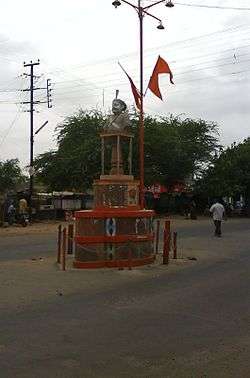
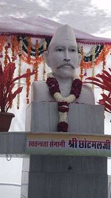
The junction (Chowk) outside the Bali Fort is now named as Freedom Fighter Chotmal Surana Chowk after Late Freedom Fighter Chotmal Surana for his contribution towards India Independence Movement. The Inauguration of Chowk was done by then Governor of Gujarat Dr. Kamla Beniwal on 1 March 2011. Dr. Beniwal unveiled the statue of Late Chotmal Surana. A huge public program was said to be conducted which was joined by the entire village and is described as one of the biggest ceremonies held in the village. The event was hosted by Bali Municipal Corporation along with the Family Members of Late Freedom Fighter Chotmal Surana.
Festivals
Several festivals are celebrated in Bali with great vigor. Most prominent is that of Sitala Mata that is celebrated in March, where peasants dance in the fort of Bali. The other main festivals are Gangaur and Pashu mela. One of another big festival is Bhadra Beej celebrated by Marwadi Seervi community.
See also
References
- ↑ Archibalds Adams (1899) The Western Rajputana States, Junior Army and Navy Stores, London
- ↑ Falling Rain Genomics, Inc - Bali
- ↑ "Census of India 2001: Data from the 2001 Census, including cities, villages and towns (Provisional)". Census Commission of India. Archived from the original on 2004-06-16. Retrieved 2008-11-01.
- ↑ Bali
- ↑ Election Results of Bali,Rajasthan
- ↑ Bali Tehsil/Mandal
- ↑ National Panchayat Dirctory
- ↑ Bali tehsil
- ↑ Bali tehsil population
- ↑ "About us". Fabindia Schools.