Smelter Mountain
| Smelter Mountain | |
|---|---|
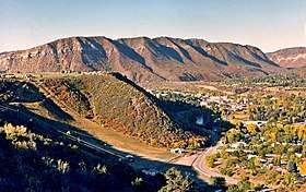 Smelter Mountain seen from Rim Drive | |
| Highest point | |
| Elevation | 7,725 ft (2,355 m) [1] |
| Prominence | 565 ft (172 m) [1] |
| Coordinates | 37°15′44″N 107°54′22″W / 37.2622244°N 107.9061786°WCoordinates: 37°15′44″N 107°54′22″W / 37.2622244°N 107.9061786°W |
| Geography | |
 Smelter Mountain Colorado  Smelter Mountain Smelter Mountain (the US) | |
| Location | La Plata County, Colorado, United States |
| Parent range | La Plata Mountains |
| Topo map | USGS Durango West |
| Climbing | |
| Easiest route | Hiking trail |
Smelter Mountain[2] is part of the La Plata Mountains range which is a subset of the Rocky Mountains of North America. It is located in the Bodo State Wildlife Area, 1.2 miles (2 km) southwest of the community of Durango in La Plata County, Colorado, United States. Smelter Mountain rises over 1,200 ft (370 m) above the town, and the lower slope of the mountain was home to the Durango smelter, hence the name of the mountain. Precipitation runoff from Smelter Mountain drains into tributaries of the Animas River. A 1.2 mile hiking trail leads to the summit, and other recreational activities include hunting and paragliding.[3]
References
- 1 2 "Smelter Mountain, Colorado". Peakbagger.com.
- ↑ "Smelter Mountain". Geographic Names Information System. United States Geological Survey. Retrieved 2018-08-27.
- ↑ The Durango Herald, July 10, 2018

This article is issued from
Wikipedia.
The text is licensed under Creative Commons - Attribution - Sharealike.
Additional terms may apply for the media files.