Sarralbe
| Sarralbe | ||
|---|---|---|
| Commune | ||
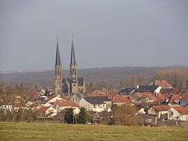 A general view of Sarralbe | ||
| ||
 Sarralbe Location within Grand Est region  Sarralbe | ||
| Coordinates: 49°00′N 7°02′E / 49.00°N 7.03°ECoordinates: 49°00′N 7°02′E / 49.00°N 7.03°E | ||
| Country | France | |
| Region | Grand Est | |
| Department | Moselle | |
| Arrondissement | Sarreguemines | |
| Canton | Sarralbe (chef-lieu) | |
| Intercommunality | Communauté de communes de l'Albe et des Lacs | |
| Government | ||
| • Mayor (2008–2014) | Pierre-Jean Didiot | |
| Area1 | 27.29 km2 (10.54 sq mi) | |
| Population (1999)2 | 4,538 | |
| • Density | 170/km2 (430/sq mi) | |
| Time zone | UTC+1 (CET) | |
| • Summer (DST) | UTC+2 (CEST) | |
| INSEE/Postal code | 57628 /57430 | |
| Elevation |
206–262 m (676–860 ft) (avg. 210 m or 690 ft) | |
|
1 French Land Register data, which excludes lakes, ponds, glaciers > 1 km2 (0.386 sq mi or 247 acres) and river estuaries. 2 Population without double counting: residents of multiple communes (e.g., students and military personnel) only counted once. | ||

Sarralbe (German: Saaralben, Lorraine Franconian: Alwe) is a commune in the Moselle department in Grand Est in north-eastern France.
See also
External links
| Wikimedia Commons has media related to Sarralbe. |
- Sarralbe Info - Site d'informations sur Sarralbe
- Sarralbe point net
- Sarralbe television
| Authority control |
|---|
This article is issued from
Wikipedia.
The text is licensed under Creative Commons - Attribution - Sharealike.
Additional terms may apply for the media files.