Cricklade
| Cricklade | |
|---|---|
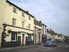 Jubilee Clock and part of the High Street | |
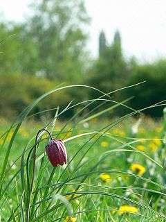 Snake's head fritillaries in the National Nature Reserve, with the Anglican church behind | |
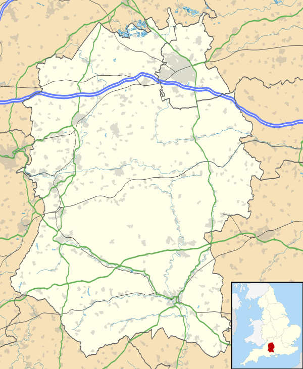 Cricklade Cricklade shown within Wiltshire | |
| Population | 4,227 (in 2011)[1] |
| OS grid reference | SU101936 |
| Civil parish |
|
| Unitary authority | |
| Ceremonial county | |
| Region | |
| Country | England |
| Sovereign state | United Kingdom |
| Post town | Swindon |
| Postcode district | SN6 6 |
| Dialling code | 01793 |
| Police | Wiltshire |
| Fire | Dorset and Wiltshire |
| Ambulance | South Western |
| EU Parliament | South West England |
| UK Parliament | |
| Website | Town Council |
Cricklade is a small Cotswold town and civil parish on the River Thames in north Wiltshire, England, midway between Swindon and Cirencester. It is the first town on the Thames as it flows towards London.[2] The parish population at the 2011 census was 4,227.[1]
Cricklade's Latin motto In Loco Delicioso means "in a pleasant place".[3] In 2008 the town was awarded Best Small Town in UK in the Royal Horticultural Society's Britain in Bloom Finals and in 2011 the Champion of Champions award in the Britain in Bloom competition.[4] It hosts several sporting events and the annual Cricklade Show. The large Jubilee Clock was erected in 1898 in honour of Queen Victoria's Diamond Jubilee in the preceding year. It stands outside the Vale Hotel in High Street, where the Town Cross once stood. There are two sculptures of the Holy Cross in Cricklade, one in the churchyard of St Sampson's, the other at St Mary's. There is local rivalry about which is believed to be older.
History
Cricklade was founded in the 9th century by the Anglo-Saxons, at the point where the Roman road Ermin Way crossed the River Thames. It was the home of a royal mint from 979 to 1100; there are some Cricklade coins in the town museum.[5][6] The Domesday Book records Cricklade as the meeting place of Cricklade Hundred in 1086.
It is one of thirty burhs (fortresses or fortified towns) recorded in the Burghal Hidage document, which describes a system of fortresses and fortified towns built around Wessex by King Alfred. Recent research has suggested that these burhs were built in the short period 878–79, to defend Wessex against the Vikings under Guthrum, and to act as an offensive to the Viking presence in Mercia. It is argued that the completion of this system – of which Cricklade was a key military element, being a short distance down Ermin Street from Cirencester, the Viking base for a year – precipitated the retreat of the Vikings from Mercia and London to East Anglia, according to the Anglo-Saxon Chronicle in late 879.[5]
The square defences of the fortification were laid out on a regular module. They have been excavated in several places on all four of its sides since the 1940s, making this is possibly the most extensively sampled fortification of the period. In the initial phase, a walkway of laid stones marked the rear of a bank of stacked turfs and clay, which had been derived from the three external ditches.[6] In the second phase, the front of the bank, which after probably only a short period of time had become somewhat degraded, was replaced by a stone wall. This encircled the defences on all four of its sides. The manpower needed to build this was probably similar to what was needed to build the original turf and clay defences. It would have considerably strengthened the defensive capabilities of the burh. It has recently been suggested that it was inserted in the 890s. That other burhs of the Burghal Hidage were also strengthened with stone walls, which suggests this was part of a systematic upgrade of the defensive provisions for Wessex, ordered at the time by the king.[6]
The third phase is marked by systematic razing of the stone wall, which was pulled down over the inner berm (the space between the wall and the inner ditch). Stones from it were used to fill the inner two ditches, which shows that the process was deliberate. A similar phase can be seen in the archaeological record at Christchurch, Dorset, another burh of the Burghal Hidage. Observations at other burhs also suggest that this phase of destruction was implemented over the whole of Wessex, and must therefore have been the result of a concerted policy, again by inference on the part of the king. The most reasonable historical context for this seems to be accession of King Cnut in the early 11th century, to prevent the burhs being seized and used against him by his rivals.[6]
The fourth phase is marked by reuse of the original Anglo Saxon defences by inserting a timber palisade along the line of the original wall. This probably marks a renewal of the defences of the town during the civil war of 1144 under King Stephen.[6]
There is little archaeological evidence of the community protected by these defences in the Saxon period. There is some sign that streets were laid out in a regular fashion behind the main north–south High Street. This led through a gate in the northern line of the defences to a causeway over the flood plain of the Thames to a bridge over the river, which was probably of a defensive nature.[6]
On John Speed's map of Wiltshire (1611), the town's name is recorded as Crekelade.[6] Cricklade Museum houses several publications recounting further historical details of the town and its people.[7]
Governance
The civil parish elects a town council. It is in the area of Wiltshire Council unitary authority, which performs most significant local government functions.
Outlying hamlets in Cricklade parish are Calcutt, Chelworth Lower Green, Chelworth Upper Green, Hailstone Hill and Horsey Down.
There is an electoral ward with the name of Cricklade and Latton, which combines Cricklade parish with its neighbours to the north east: Latton and Marston Maisey. The population of the ward recorded in the 2011 census was 4,982.[8]
The parish is in the North Wiltshire parliamentary constituency. From 1295 the Cricklade constituency returned two members of parliament. This parliamentary borough represented just the town until 1782, when its boundaries were extended into the surrounding countryside. It later came to include Swindon, then a village. In 1885, Cricklade became a county constituency electing a single member. Cricklade constituency was abolished in 1918, with the town joining Chippenham, which was renamed to North Wiltshire in 1983, and had its boundaries redrawn in 2010 when Chippenham was given its own seat.
Culture
Sport and pastimes
Rugby Union
The club was founded in 1992 by ex-school players from many schools at the bar of the Vale Hotel, Cricklade, then owned by ex-President and life members the Ross family. Initially players were committed to other clubs, so Sunday fixtures were played, the first one against Aldbourne on 6 September.[9] In its second season the fixtures moved to Saturdays. The club joined the Dorset & Wilts leagues in 1994 but withdrew as the travelling involved was too burdensome. They were able to rejoin in 2001 when the leagues were re-structured into North and South.[9]
The club originally used pitches from Prior Park School and the Duke of Gloucester Barracks. Since 2001 it plays on a prepared pitch in the town leased by the Town Council.[9] The first game to be played there was between Cricklade and the President's select XV squad from all rival clubs – about a dozen clubs formed the squad, who played in Gloucester jerseys donated for the day by Gloucester RFC.[9]
Over the years Cricklade Rugby Club has toured over England, West and South Wales and Ireland, with teams spanning a broad range of levels of skill and age category.[9]
Shows and festivals
The Cricklade Show is held each summer, typically featuring music, dancing and a cricket match.
The town holds an annual festival, usually taking place on Father's Day in June.[10]
Charity sports
Run annually in the first Sunday of October, the Cricklade Fun Run hosts a half marathon, 10 km and Fun Run event for around 750 runners. This raises funds for a number of local charities.[11]
The Cricklade Triathlon runs in the summer for both adults and juniors.[12]
Leisure centre
Towards the end of 2006, North Wiltshire District Council proposed closing the leisure centre. After a campaign, the local residents took over the running of the centre and were successful in turning its declining fortunes. It has a swimming pool, squash courts, sports hall with a range of markings, tennis/five a side football courts, bar and lounge area with balcony and barbecue, skate park and children's play areas. In 2009 money was raised for a climbing wall.[13]
Cricket
Cricklade Cricket Club was established in 1877 and has been located since 1947 on the north side of Cricklade, where its ground (Southam) is next to the River Thames. For the 2016 season the club is running two senior Saturday teams, a friendly Sunday team, a midweek team and three youth teams (U15, U13 and U11s), all in the local Cotswold District Cricket Association leagues.
Association Football
Cricklade Town F.C. is a non-League football team which plays at the Cricklade Leisure Centre.
Cricklade Youth Football Club provides and promotes the playing of association football for the youth of Cricklade from U7s to U16s. The club was the first in Wiltshire to gain the Wiltshire FA Charter Standard, an award for clubs across the country that meet the high standards required by the Football Association.[14]
Cricklade cinema
Since Autumn 2013, Cricklade Town Hall has shown films every 4th Tuesday of the month from September to April. They include recent releases, classics, and non-mainstream films.[15]
Nature
North Meadow
Today, the town's main claim to fame is the large nature reserve, North Meadow, which preserves some 80 per cent of Britain's wild snake's head fritillaries in its 150 acres (61 ha), which flower in late April to early May. The meadow is situated between two rivers, the Thames and the Churn, and the unique habitat for the fritillary was created by winter flooding. Such meadows were once common in Britain, but with the advent of modern farming many were drained and ploughed for arable crops from the 1730s onwards. North Meadow escaped such a fate by preserving the court leet, the Saxon system of town governance which ensured the land was held in common. The land is managed by Natural England[16] and is run with the support of the court leet.
Blakehill
In 2000, a disused airfield, formerly RAF Blakehill Farm, was bought from the Ministry of Defence by Wiltshire Wildlife Trust[17] to form a second larger meadow of around 600 acres (240 ha), which was opened to the public in 2005. It rears a small quantity of organic grade beef, usually using rare breeds such as Longhorns.
Cotswold Water Park
Cricklade lies between the east and west sections of the Cotswold Water Park, an extensive nature reserve formed from disused gravel pits.
Schools
St Sampson's C of E Primary School
There was a state primary school called St Sampson's Church of England School, which was linked with the major local landmark, the Anglican St Sampson's parish church. It was separated in 1979 into two schools, on the same Bath Road site: St Sampson's Infants' School, for ages 4–7, and St Sampson's C of E Junior School, for ages 7–11.[18] In 2014, the schools merged to form St Sampson's C of E (VC) Primary School.[19]
Cricklade Manor Preparatory School
This independent school is non-selective and has around 200 pupils aged 3–13.[20] It is housed in the late 19th-century Manor House, which until 2017 housed a prep school linked to Prior Park College, Bath.[21]
Meadowpark School
Meadowpark is a small independent school, established in 1996, for children of 4–11.[22] It is housed in the former St Mary's School, built in 1860 just south of the Town Bridge.[23]
Churches
Anglican
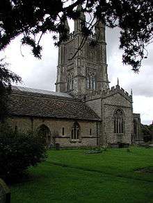
St Sampson's is the town's Church of England parish church. Dating back to the 12th century, it is dedicated to the 5th-century Welsh saint, Samson of Dol. The present church was built on the remains of another, Saxon church of AD 890. The main part of the church was built in 1240–80, although on closer inspection, the earlier work can still be found. The large tower with four corner pinnacles, the dominant landmark of the town, was built much later in 1551–53 by John Dudley, 1st Duke of Northumberland, father-in-law to Lady Jane Grey. The church is a Grade I listed building.[24]
Roman Catholic
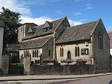
Since 1984, St Mary's Church has been leased by the Catholic congregation, after it was declared redundant by the Church of England in 1981.[25] The building is Grade II* listed.[26]
The building, just inside the Saxon town wall, dates from the 12th century and has a low tower completed about 1400.[27] St Mary's had its own small parish, the northern part of the town and its environs, until 1952 when the parish was united with St Sampson's.[28]
In the churchyard, south of the church, is a complete 14th-century limestone cross, a Grade I listed structure.[29]
United Church
Cricklade United Church, Calcutt Street, was built by Congregationalists in 1878, in front of their smaller meeting house of 1799 which is now the church hall. The congregation joined the United Reformed Church at its formation in 1972, and later joined with the Methodists to create Cricklade United Reformed and Methodist Church.[30][31]
Former Methodist chapels
Primitive Methodists built a hall in Calcutt Street, near the High Street, in 1855,[32] and the Wesleyans built theirs just north of the town bridge, near the Priory, in 1870.[33]
In 1938 the two churches united and used the Calcutt Street hall. The Priory building was at first a Sunday school, then after the Second World War was taken over by Wiltshire County Council Education Department, and is now a community hall called Thames Hall. The Calcutt Street building became a doctors' surgery after the move to the United Church.[34]
Twinning
Cricklade has been twinned with the French town of Sucé-sur-Erdre since 1990. In June 2010 the 20th anniversary was celebrated in Cricklade.[35] Sucé is located just north of Nantes in the Loire Valley, 30 miles (48 km) from the Atlantic coast. Visits are exchanged in alternate years. Cricklade Twinning Association also hold social events throughout the year to raise funds towards hosting the visits by Sucé to Cricklade.
Saxons Rest controversy
In 2009 Cricklade Town Council (with help from Cricklade Bloomers) built a town garden on an open space near Waylands called Saxons Rest which included two large flag poles.[36] This however caused some controversy among the residents of the High Street, who considered that their view across the open space would be spoilt and that there would be noise from the halyards on the flag poles. The build went ahead despite a significant number of people signing a petition against it. The majority of the opinion was against the two flag poles, which many residents felt were a needless and pretentious feature. Once built the consensus was that it was an attractive feature in the town and enhanced the area. The overriding feeling was that the town's funds would be best directed elsewhere. One of the suggestions voiced was the prevention of crime and vandalism in the town, which was on the rise. The open space to the rear of the garden is a scheduled monument as this is the location of the Saxon town walls which although no longer visible, are considered historically important. Despite this Saxons Rest was built, which in turn put to rest the remains of the Saxons' walls.
Business and economy
Cricklade Business Association[37] was set up to represent the local business community, the association also has close links to other non-profit making businesses, such as the Rotarians, Waylands Trust and the charity running the leisure centre.
Cricklade has many public houses. These currently include the Vale, the Old Bear, the White Hart, and the Red Lion. Drinks are also sold at the White Horse Members' Club and the leisure centre. An above-average proportion of the population of the ward is retired, as at the 2011 census.[38]
There is a local museum in Calcutt Street run by the Cricklade Historical Society and housed in a former Baptist chapel. T. R. Thomson of Costorphine was a long-time resident of Cricklade and a moving spirit behind the establishment of the society. His book, Materials for a History of Cricklade, and various articles have preserved and enhanced the study of local history in the town.
Notable people
In birth order:
- Robert of Cricklade (c. 1100–1174×79) was a teacher and later a prominent writer based in Cirencester Abbey and the Priory of St Frideswide, Oxford.
- John Hungerford (c. 1566–1635) was a politician whose interest in Cricklade led him to build the market house in the High Street and a flying buttress for the Lady Chapel of St Sampson's Church.
- Robert Jenner (1584–1651), merchant and politician, founded a school in Cricklade and was buried here.
- Nevil Maskelyne (1611–1679), was a landowner and MP for Cricklade. He gained the town a weekly market and four fairs a year from 1662.
- George R. Poulton (born 1828), the American composer of the song "Aura", was born here.
- Reginald Arkell (1882–1959), script writer, novelist and humorist, died here.
- Ellis Peters (1913–1995), set her medieval mystery novel Brother Cadfael's Penance in Cricklade.
- Francis Maddison (1927–2006), historian and Arabist, directed archaeological excavations in Cricklade.
Transport
The Thames Path runs through Cricklade. It heads downstream on the south bank to Eysey Footbridge, where it crosses to the other bank.
The North Wilts Canal, opened in 1819, passed just to the west of the town. It linked the Thames and Severn Canal with the Wilts and Berks Canal. Abandoned in the early 20th century, parts are now being restored.[39] The Town Bridge at Cricklade, built in 1812, marks the limits of navigational rights on the River Thames.[40]
Cricklade railway station was on the Midland and South Western Junction Railway, which linked Swindon with Cirencester, but this was closed in 1961 and all trace of the station has now gone. Part of the railway route has been opened as a cycle path (national cycle route 45). South of the town, the Swindon and Cricklade Railway is restoring the line as a leisure facility. Since 2007 passenger trains have been run between Blunsdon and Hayes Knoll, and the line is currently being extended towards both Cricklade and Swindon. Since 2014 the line has been extended to Taw Valley Halt on the edge of Swindon.
The nearest railway station to Cricklade is Hayes Knoll. The nearest mainline railway station is Swindon on the Great Western Main Line.
The A419 Swindon to Cirencester road bypasses the town to the north-east.
See also
- Cricklade (UK Parliament constituency) (1295-1918)
- Down Ampney, 5 miles (8.0 km) to the north, birthplace of 20th century English pastoral composer Ralph Vaughan Williams, who also wrote spiritual music and edited the first edition of the English Hymnal and drew on folk music of the area.
References
- 1 2 "Wiltshire Community History - Census". Wiltshire Council. Retrieved 8 January 2015.
- ↑ "Cricklade". VisitWiltshire. Retrieved 6 July 2017.
- ↑ "Cricklade Town Council".
- ↑ "RHS 2011 Results". Archived from the original on 17 October 2011.
- 1 2 Christopher Winn: I Never Knew That about the River Thames (London: Ebury Press, 2010), p. 6.
- 1 2 3 4 5 6 7 "Cricklade Historical Society". Archived from the original on 14 July 2011.
- ↑ "Cricklade Museum". cricklademuseum.co.uk. Retrieved 29 July 2016.
- ↑ "Cricklade and Latton - 2011 Census". Neighbourhood Statistics. Office for National Statistics. Retrieved 13 May 2016.
- 1 2 3 4 5 Cricklade Rugby Club
- ↑ "Cricklade Festival". crickladefestival.com. Retrieved 30 July 2016.
- ↑ Cricklade Fun Run
- ↑ Cricklade Triathlon Archived 18 April 2009 at the Wayback Machine.
- ↑ Cricklade Leisure Centre
- ↑ Cricklade Youth Football Club Archived 13 September 2013 at the Wayback Machine.
- ↑ "Cricklade Cinema! | BFI Neighbourhood Cinema". www.bfi.org.uk. Retrieved 2018-05-16.
- ↑ Natural England
- ↑ "Wiltshire Wildlife Trust". Archived from the original on 26 July 2009. Retrieved 15 February 2011.
- ↑ "St. Sampson's C. of E. Junior School, Cricklade". Wiltshire Community History. Wiltshire Council. Retrieved 13 May 2016.
- ↑ "Cricklade school merger will go ahead". Swindon Advertiser. 3 May 2014. Retrieved 17 May 2016.
- ↑ "Cricklade Manor Prep". cricklademanor.com. Retrieved 24 January 2018.
- ↑ Historic England. "The Manor House (1356093)". National Heritage List for England. Retrieved 24 January 2018.
- ↑ "EduBase details for Meadowpark School". Department for Education. Retrieved 17 May 2016.
- ↑ "St. Mary's Girls' School, Cricklade". Wiltshire Community History. Wiltshire Council. Retrieved 17 May 2016.
- ↑ Historic England. "Church of St Sampson (1023081)". National Heritage List for England. Retrieved 17 May 2016.
- ↑ "History of St Mary's". Friends of St Mary's Church. Retrieved 17 May 2016.
- ↑ Historic England. "Church of St Mary (1183154)". National Heritage List for England. Retrieved 17 May 2016.
- ↑ "Church of St. Mary, Cricklade". Wiltshire Community History. Wiltshire Council. Retrieved 17 May 2016.
- ↑ "No. 39678". The London Gazette. 24 October 1952. pp. 5590–5591.
- ↑ Historic England. "Churchyard cross, in churchyard, Church of St. Mary (1023108)". National Heritage List for England. Retrieved 17 May 2016.
- ↑ "United Church, Cricklade". Wiltshire Community History. Wiltshire Council. Retrieved 17 May 2016.
- ↑ "Cricklade United Church". Retrieved 17 May 2016.
- ↑ "Primitive Methodist Chapel, Cricklade". Wiltshire Community History. Wiltshire Council. Retrieved 17 May 2016.
- ↑ "Wesleyan Methodist Church, Cricklade". Wiltshire Community History. Wiltshire Council. Retrieved 17 May 2016.
- ↑ Historic England. "Wesley Hall (1023092)". National Heritage List for England. Retrieved 17 May 2016.
- ↑ "Twinning Visits". Cricklade and District Twinning Association. Retrieved 6 July 2018.
- ↑ "Residents enjoying new community garden". Wilts and Glos Standard. 12 August 2009. Retrieved 8 January 2015.
- ↑ http://www.crickladebusiness.org.uk/
- ↑ 2011 Census The Office for National Statistics
- ↑ North Wilts Canal
- ↑ Christopher Winn... p. 8.
Further reading
- Pevsner, Nikolaus; Cherry, Bridget (revision) (1975) [1963]. Wiltshire. The Buildings of England. Harmondsworth: Penguin Books. pp. 199–202. ISBN 0140710264.
- Pugh, R.B.; Crittall, Elizabeth (eds.) (1956). A History of the County of Wiltshire, Volume 3 - Hospitals: St John the Baptist, Cricklade. Victoria County History. pp. 335–336.
External links
| Wikimedia Commons has media related to Cricklade. |
- Cricklade Town Council
- Cricklade at Curlie (based on DMOZ)
- Cricklade in the Domesday Book