Sandy Lane, Wiltshire
Coordinates: 51°24′43″N 2°03′07″W / 51.412°N 2.052°W
Sandy Lane is a small village situated between the towns of Chippenham and Devizes in Wiltshire, England, and between the villages of Bromham and Derry Hill on the A342 road.[1]
The village lies to the north of the Roman road from Bath to London. The small Roman town of Verlucio was to the southeast,[2][3] and the site of a Roman villa was discovered at Nuthills Farm in 1924.[4]
The village is largely in the civil parish of Calne Without; the boundary of the parish of Bromham runs immediately to its west. Wiltshire Council is the unitary authority which is responsible for all significant local government functions.
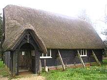
Sandy Lane has several well-preserved thatched cottages. The church of St Nicholas is also thatched.[5]
There is a public house, the George Inn, a two-storey 18th-century building re-fronted in the 19th century.[6]
References
- ↑ OS Explorer Map 156, Chippenham and Bradford-on-Avon Scale: 1:25 000.Publisher: Ordnance Survey A2 edition (2007). ISBN 978-0319239438
- ↑ "Verlucio". PastScape. English Heritage. Retrieved 10 February 2015.
- ↑ Linford, N T; Linford, P K; Payne, A W (February 2018). "Verlucio and Environs Project, Bowood Estate, Calne Without, Wiltshire: Report on Geophysical Surveys". Historic England. Retrieved 5 August 2018.
- ↑ "Monument no. 212025". PastScape. English Heritage. Retrieved 10 February 2015.
- ↑ "Wiltshire Community History - Church of Saint Nicholas, Sandy Lane". Wiltshire Council. Retrieved 10 February 2015.
- ↑ Historic England. "The George Inn (1253596)". National Heritage List for England. Retrieved 5 August 2018.
| Wikimedia Commons has media related to Sandy Lane, Wiltshire. |