Inverkip
Inverkip
| |
|---|---|
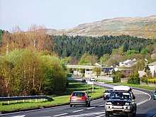
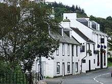
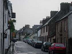 Inverkip's Main Street | |
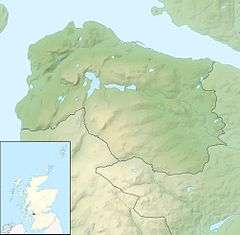 Inverkip Inverkip shown within Inverclyde | |
| OS grid reference | NS 20675 71938 |
| Council area | |
| Lieutenancy area | |
| Country | Scotland |
| Sovereign state | United Kingdom |
| Post town | GREENOCK |
| Postcode district | PA16 |
| Dialling code | 01475 |
| EU Parliament | Scotland |
| UK Parliament | |
| Scottish Parliament | |
Inverkip (Scottish Gaelic: Inbhir Chip) is a village and parish in the Inverclyde council area and historic county of Renfrewshire in the west central Lowlands of Scotland, 4 miles (6.4 km) southwest of Greenock and 9 miles (14.5 km) north of Largs on the A78 trunk road. The village takes its name from the River Kip. It is served by Inverkip railway station.
History
Origins
In the year 1170, Baldwin de Bigres, the Sheriff of Lanark, granted a stretch of land to the monks of Paisley Abbey. This land was described as “The pennyland between the rivulets Kip and Daff”.[1] Pennyland is an old Scots word of Norse origin which is used to describe a small piece of land, the rent for which is one penny per year.
The area granted to the monks in 1170 equates to much of the north section of today's village, from the bridge over the Daff on Main Street, near Inverkip Hotel to the old bridge over the Kip at Bridgend Cottages. Extending to the coast at the old bridge at Kip Marina and probably as far inland as the railway line.
Inverkip was made a burgh of barony before the Act of Union in 1707, with the parish containing all of Gourock, Wemyss Bay, Skelmorlie and part of Greenock.[2]
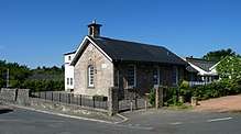
Inverkip Church
By 1188, the monks had built a church on the site of the present old graveyard, at what is now the junction of Langhouse Road and Millhouse Road. This small church (known as Auld Kirk) served the entire Christian population between Kilmacolm and Largs for around 400 years. The existing (derelict) mausoleum of the Shaw-Stewarts stands on the site of the original church and incorporates some of its structure. The Christians of Greenock presented a petition to the Crown for a Church of their own. This resulted in the opening of the Old West Kirk in Greenock in 1859 and brought to an end the regular six mile each way treks by Sunday worshipers from Greenock to Inverkip. A journey which must have been very demanding, given the terrain and the absence of proper roads during that period.
The present church building on Langhouse Road was completed in 1805, reputedly to a plan by the civil engineer Thomas Telford, but there is no evidence to support this and the design of Inverkip Church is quite different from the known 'Telford Kirks' which were built during the same period. The church building is described by Historic Environment Scotland as "2-storey type; simple Renaissance with upper windows round-headed; open belfry at front gable; (1804-5). Clock on pediment several of windows blocked up, but fenestration pattern kept in black & white".
The church hall and manse were built during the 1960s and stand across Langhouse Road from the church itself. The old manse (now known as Kirkbrae house) is also on Langhouse Road, between the original and present churches. It was built in 1730 and is now a private residence.
Ardgowan
By the 13th century, a castle had been built at what is now Ardgowan House. This early castle changed hands between the Scots and the English during the Wars of Independence. Robert The Bruce fought here for both sides during this period. The land was acquired by the Stewarts in 1390 and they built the existing castle during the 15th century. Contained in the gardens of Ardgowan House and away from the public eye, it consists of a three-storey square keep with a garret. The main entrance is at first floor level and is accessed by an external stairway. The castle was abandoned as a residence when Ardgowan House was built by the Shaw-Stewarts in 1799-1801. Following construction of Ardgowan House, the first proper road to Greenock was constructed by Sir John Shaw Stewart, it opened in 1803.
Ardgowan House served as a military hospital during both world wars and has the distinction of being the first Scottish military hospital to be damaged by German bombs. The damage was slight and no casualties were recorded, but many windows at the house were smashed.
Witchcraft & Witch Hunts
Inverkip was a hotbed of witchcraft activity for half a century from 1640 to 1690. The Ministers of the parish at the time, the Rev John Hamilton (1626 to 1664) and Rev Alexander Leslie (1665 to 1684) were noted as being ‘zealous persecutors of witches’. A Royal Enquiry into the Inverkip witch hunts, which have been compared to those at Salem, was led by Archibald Stewart of Blackhall. During this enquiry 18 year old Marie Lamont was tried as a witch before the Commission, Sir Archibald and the Rev John Hamilton. Marie confessed that ‘Jean King, Kattie Scott, Janet Holm, herself and sundry others, met together in the mirk, at the bucht-gait of Ardgowan whar, the devil was with them in the shape of a black man with cloven feet, and directit them to fetch whyte sand fre the shore, and cast it about yetts of Ardgowan and about the ministers hous’. Marie was found guilty of witchcraft and burned at the stake, the fate of the others is not known.[3]
A local verse recalls another notable character during this period...
"In Auld Kirk the witches ride thick
And in Dunrod they dwell;
But the greatest loon amang them a'
Is Auld Dunrod himsel'."
'Auld Dunrod' was the last of the Lindsay family of Dunrod Castle. As the result of a dissolute life he lost all his possessions and fell into the black arts. Local reputation had it that he was in league with the devil, and he died in mysterious circumstances in a barn belonging to one of his former tenant farmers. Nothing now remains of the castle which stood at the foot of Dunrod Hill.[4]
Shaws Water Scheme
Commissioned by Sir Michael Shaw Stewart and designed by industrialist Robert Thom of Rothesay, this grand water supply scheme in the hills behind the village was completed in 1827. It entailed the damming of Shaws Water (a small stream on the other side of the hills from Greenock) to create what is now known as Loch Thom. The Greenock Cut was also created to supply water from the loch, around the hills, to the town of Greenock for domestic and industrial purposes.
The scheme was still in use as recently as 1971, at which time it was made obsolete by the boring of a tunnel through Whinhill.
Cholera Outbreak
1849 was a disastrous year for the village; not only did the crops fail, but one third of the population died due to an outbreak of cholera.
Smuggling
During the late 18th century and early 19th century, the village was noted for smuggling activities involving the illicit transfer of alcohol, tea and tobacco from vessels heading up the Firth of Clyde to the ports of Greenock and Port Glasgow.
One well known case is that of Thomas Finnie, a local milkman, whose tale is recorded in the records of the Innerkip Society:
“Early in the morning of the 22nd of December, 1809, about 6 am, Thomas Spence, Supervisor of Excise in Greenock, could have been seen – suitably armed with pistol, etc – riding through the slush to Inverkip accompanied by two other officers. Almost exhausted and perished with the cold after their unusual errand they espied Thomas Finnie’s milk cart. They lay in wait near the Daff burn and when Thomas had reached that point on his way to the “big house” with his morning delivery, the command to halt came from Spence. Mr Spence immediately searched the cart and in addition to the usual and necessary commodity of milk, he found three casks of Highland whisky containing in all 30 gallons. The horse, cart, milk and whisky and, of course, Thomas, were seized and taken in charge when, suddenly, Spence spotted Robert Cochrane some distance off. Cochrane was also searched and his cart was found to contain 50 gallons of Whisky. Both carts, their contents and their owners were marched on to Greenock Bridewell.”
The Railway
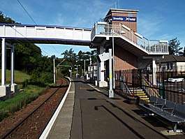
1865 saw the opening of the Port Glasgow to Wemyss Bay line by the Greenock and Wemyss Bay Railway Company, with the trains being operated by the Caledonian Railway Company. A station was opened at Inverkip in 1867 and this resulted in the transformation of Inverkip from a rural agricultural village community to being more of a seaside resort busy with railway trippers from Greenock and Glasgow. A jetty near the present day War Memorial served ferry boats which tendered to the passing Paddle Steamers. The railway line was electrified in 1967 and has been served by EMUs (Electric Multiple Units) of various classes since then. The line was made single track at this time, which resulted in Inverkip station being reduced to a single platform and losing its bridges across the line. A new footbridge across the line was opened in 2014.
Energy Supplies
By 1900 a gas supply was piped to the village from Bankfoot, which was the home farm of Ardgowan Estate and which is located around a mile outside the village on the road to Greenock. The 1913 OS 25 inch map shows a gasometer at the farm[5]
Electricity arrived in the village in 1932, supplied from the Hydro scheme in nearby Skelmorlie.
World War II
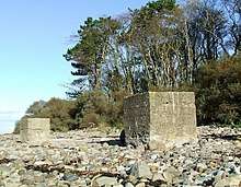
The mouth of Kip Water was excavated in 1940 by the Army Royal Engineers Unit to enable the storage barges. After the war, this excavated area became a popular bathing and boating area with locals and day-trippers alike.
Two large concrete blocks on the beach nearby are probably tank traps, a relic of this time.
Kip Marina now stands on the site of the WWII excavation.
The army built and occupied 28 houses in Daff Avenue at this time. These houses survive today and can be seen just off Main Street at Langhouse Road.
Housing
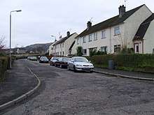
From 1951-1957 Renfrewshire County Council built the Crawford Lane and Glebe Road housing scheme. This development lies on the high ground at Langhouse Road, behind the present church building. This provided much needed affordable, good quality housing to local people in the immediate post-WWII years.
Since the 1980s the village has seen many large private housing developments completed, including off Langhouse Road, Swallow Brae, Kip Marina and several at the 'Hill Farm' site off Finnockbog Road. Further housing developments are planned at the former power station site.
The village now serves largely as a dormitory to Greenock and the major towns beyond.
Road Transport
The village stands on the A78 coast road which runs from Greenock to Monkton, near Prestwick Airport. Main Street was the A78 road until the bypass opened in the early 1970s.
The single carriageway bypass road was designed with wide margins to provide long sight lines and to enable future construction of a dual carriageway if traffic demanded it. Evidence of this can be seen at the flyover at the power station access road, which is dual carriageway, with just one side being used.
Despite the bypass, Main Street is still congested due to the presence of many parked cars.
Inverkip Power Station (demolished)
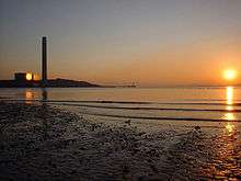
This was an oil fired power station which was constructed during the 1970s and demolished from 2010-2015. Due to the increase in oil prices as a result of the 1973 Oil Crisis, the station was never used commercially, at least never to full capacity (except during the coal miners strike of 1984/85). Power generation stopped in 1988 and the station was kept in reserve before being mothballed in the late 1990s. It was decommissioned in 2006 at which time some of the equipment was sold and transferred to other power stations around the country.
The 700 foot chimney was the tallest free standing structure in Scotland and the third tallest in the UK.
Population
Since its origins, the village population has grown from around 200 to around 3300 (2016 projection). The population of the village has doubled since the 1980s housing boom.
Places of interest
Kip Marina
.jpg)
Today Inverkip is most notable for Kip Marina, which was the first marina in Scotland and one of only three in the UK when it opened in 1971.
Located at the mouth of Kip Water in an area that was excavated for use as barge storage during WWII, the marina has grown steadily over the years and now has over 600 berths and associated marine services such as a chandlery, sales and repair services.
The Chartroom bar & restaurant at the marina caters not only for sailors, but also the wider community, including the adjacent Kip Marina Village which is a housing estate which was established in the 2000s.
The marina hosts the annual Scotland's Boat Show [6] each October.
Greenock Cut Visitor Centre
The Centre (formerly known as Cornalees Bridge Visitor Centre) is around three miles (5 km) east of Inverkip on the Loch Thom road at Cornalees Bridge.
It lies within Clyde Muirshiel Regional Park and has a ranger service. The centre includes a display which describes the history of the cut. There is also a small selection of snacks and souvenirs on offer.
A 7-mile (11.25 km) circular walk from the visitor centre offers views of Loch Thom and the surrounding reservoirs as well as stunning views of the Firth of Clyde and the south Highlands. This walk is virtually traffic-free and is suitable for mountianbikes.
The adjacent Ardgowan Fishery offers freshwater fishing for anglers of all abilities at all times of the year.
Lunderston Bay
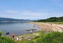
Also part of the regional park is Lunderston Bay, a popular picnic spot on the Firth of Clyde which has a ranger service and toilet facilities.
The bay is popular with bird watchers, hikers, cyclists and dog walkers. During the summer months it is a popular place for picnics and sea bathing.
A coastal path (part of the National Cycle Network, Route 75) runs south from the bay to Inverkip, via Ardgowan Estate and Kip Marina. Seals and several species of bird can be seen from the path all year round. A pod of Orcas (Killer Whales) was spotted here in early 2018[7].
Cardwell Garden Centre at the bay is a very popular visitor attraction, offering a wide range of plants plus home & garden related equipment & tools, as well as a large restaurant.
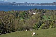
Ardgowan House
Just outside the village is the classical Ardgowan House, built for Sir John Shaw-Stewart in the late 18th century. It occasionally has open days and charity fêtes. The late 15th century Ardgowan Castle is a ruin within the estate.
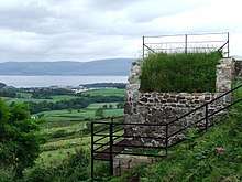
Inverkip AAOR
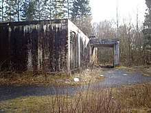
At the top of Langhouse Road a building reminiscent of the Cold War can be found in Square Wood. Known locally as 'the radar station', formally known as Inverkip Anti-Aircraft Operations Room (AAOR), the building (which is mostly underground) served "3 Group 77 Brigade, the Clyde Anchorage gun defended area (GDA)".[8]
The site was the original base of HMS Dalriada which operated there from 1965 to 1982.
Conversion to residential use commenced in early 2011, but by August 2017 little visible progress had been made outside, and the inside was several feet deep with water.
Inverkip Primary School
The village primary school is located on Station Road, in the heart of the old village. It has around 290 pupils (including a pre-5 nursery) with capacity for 320.[9]
The original 1836 two roomed school building still exists and is in daily use.
Three extensions have been added since the mid 20th century.
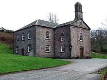
Inverkip Community Hub
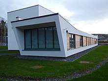
A small community Centre named 'Inverkip Community Hub' was opened in the village in early 2017. It is located at Kip Park, by the A78 Main Road at the north end of the village, between Bridgend and the village proper. It was built on the site of the grass football pitch.
The centre includes a public library, meeting rooms, a main hall which can serve as a theatre and kitchen and catering facilities for up to 100 people.
There is also a floodlit all weather sports pitch at the hub.
This is the first public community centre in the village. The previous private community centre was demolished to make way for the Kip Park retail development.
Old Church Graveyard
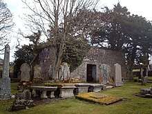
The old section of the graveyard on Millhouse Road at Langhouse Road contains the tomb of the chemist Dr. James "Parrafin" Young who was nicknamed 'Paraffin' because of his pioneering work in oil technology. He lived at the nearby Kelly Estate (above Wemyss Bay).
The graveyard also contains the derelict mausoleum of the Shaw Stewart baronets of Ardgowan. It was last used in the 1970s and is in a poor state of repair.
The mausoleum stands on the site of the original 1188 church (known as Auld Kirk) and incorporates parts of the original church.[10]
Local Businesses
Inverkip is mainly a residential village and does not possess a large number of businesses. A sub post office is located within the pharmacy in what was (until 2010) the general store on Main Street. Kip Park is a retail and business block, located at the north end of Main Street. Businesses operating there include a bistro, fish & chip shop, supermarket, hairdresser and a nursery.
Accommodation
Inverkip Hotel is a traditional Scottish village hotel, with a bar and restaurant. A former coaching inn dating back over 300 years, it is located on Main Street in the heart of the old village.
There are also at least two B&B establishments in the village.
Nearby Places of Interest
Inverkip is fairly central for other attractions, including Greenock town centre and the holiday town of Largs, which is 9 miles down the Clyde coast.
Inverkip Photo Gallery
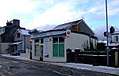 Inverkip Pharmacy and Post Office
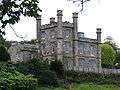 Langhouse
 Kip Park
.jpg) "Paraffin" Young gravestone
"Paraffin" Young gravestone.jpg) "Paraffin" Young and wife gravestone
"Paraffin" Young and wife gravestone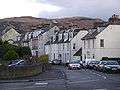 Main Street, Inverkip
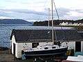 Inverkip Yacht Club
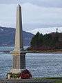 Inverkip War Memorial
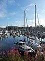 Kip Marina
- Kip Marina
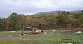 Inverkip expands south of the railway line
 Bettyburn Ford on the road to Everton
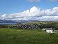 Millhouse Road, seen from Langhill Farm
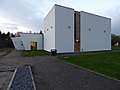 The main entrance to the community centre.
See also
Notes and references
- ↑ Canmore website
- ↑ Inverkip Parochial Board/Parish Council records
- ↑ Inverkip Church website
- ↑ Lives Of The Lindsays
- ↑ Map showing Bankfoot gasometer
- ↑ Scotland's Boat Show website
- ↑ BBC News article
- ↑ Research Study Group: Sites: Inverkip AAOR
- ↑ Inverkip Primary School website
- ↑ "Kirkbrae House, burial vault 65m ENE of, Inverclyde South West, Inverclyde". Ancient and Scheduled Monuments. 31 March 2011. Retrieved 2 July 2018.
External links
- Map sources for Inverkip
| Wikimedia Commons has media related to Inverkip. |
|
|
|
|
| Authority control |
|---|