Bishopton, Renfrewshire
Bishopton
| |
|---|---|
 Gledstane Road | |
 Bishopton Bishopton shown within Renfrewshire | |
| Population | 4,640 Estimate (mid 2012) [1] |
| OS grid reference | NS 43543 71226 |
| Council area | |
| Lieutenancy area | |
| Country | Scotland |
| Sovereign state | United Kingdom |
| Post town | BISHOPTON |
| Postcode district | PA7 |
| Dialling code | 01505 |
| EU Parliament | Scotland |
| UK Parliament | |
| Scottish Parliament | |
| Website | http://www.inbishopton.org.uk/ |
Bishopton (Scots: Bishoptoun; Scottish Gaelic: Baile an Easbaig)[2][3] is a village in Renfrewshire, Scotland. It is located around 2 miles (3.2 km) west of Erskine.[4]
History
.jpg)
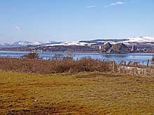
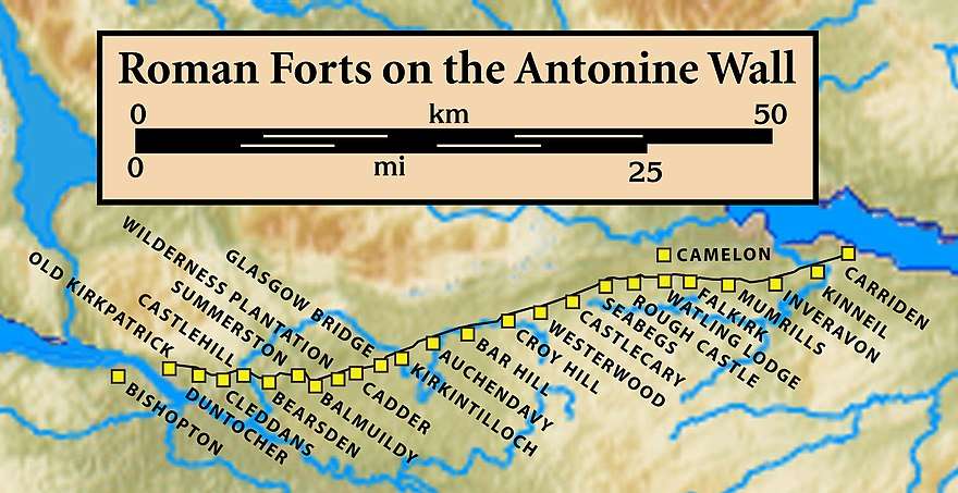
There was a Roman Fort at Bishopton which was discovered from aerial photographs in 1949.[5][6] The fort is about 1km west of the village.[7] It overlooked the former ford at Dumbuck,[8] on a flat-topped hill around 60 metres above the river, allowing ready surveillance of the River Clyde.[9] The fort at Whitemoss Farm may have been held initially from 140 to 155 A.D..[10] Pottery with Antonine era date stamps was found at the site.[11] The pottery and many other finds were catalogued at the Hunterian Museum in Glasgow[12] along with several coeval items like the distance slab of the Twentieth Legion from Old Kilpatrick.[13] There was an earlier Roman fort on Barochan Hill,[14] less than 2 miles to the south-west towards Houston.[15] Bishopton was originally in the Parish of Erskine.[16] The name of the village is reflected in a nearby house: Bishopton House.[17] A famous family called the Brisbanes lived there.[18] The house became a convent known as Good Shepherd Centre and latterly Cora Foundation.[19]
The former ROF site
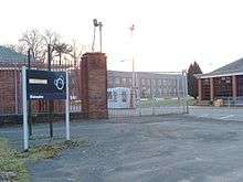
A large explosive manufacturing factory was once sited in Bishopton. The Royal Ordnance Factory Bishopton (ROF) was opened during World War II on farm land, acquired by compulsory purchase order. It was situated on the western side of the railway line running through Bishopton. Over 2,000 acres (8 km2) of land from up to seven farms was used to build the factory. The land included Dargavel House. The southern end of the site included the majority of the land formerly used by the World War I National Filling Factory, Georgetown.[20] The ROF was privatised in 1984, being sold to British Aerospace (now BAE Systems), which has since scaled down and shut most of the site.
After privatisation the MOD Police moved out and the former MOD Police Social Club at HolmPark, and its adjoining sports field, became part of Bishopton. The former MOD Police houses at both HolmPark and Rossland Crescent were sold off to private buyers. Bishopton's Medical Centre was built in a corner of the sports field, opposite the shops.
In 2005, BAE Systems and Redrow submitted proposals to use a large part of the site for building new housing which would, at least, double the size of Bishopton. Local residents indicated their concern at the proposals; the major concerns they had were with the size of the expansion – with the associated knock-on effects to the local infrastructure – and fears of the contamination that was likely to be found on the site. In December 2008 Renfrewshire Council granted outline planning consent for the development and detailed planning consent for a related motorway junction off the A8/M8.[21] By early 2016 a significant portion of the development had been completed, with a number of the houses inhabited.
Transport
.jpg)
Bishopton is located around 2 miles (3.2 km) from the southern end of the Erskine Bridge, which spans the River Clyde between Renfrewshire and West Dunbartonshire. Before the bridge was built, the Erskine Ferry transported vehicles across the Clyde. The A8 road passes through Bishopton, and the M8 motorway passes to the north, running parallel to the A8, with access to Bishopton from junctions 30 and 31. Bus services are provided by McGill's, with buses operating to Clydebank, Greenock and Erskine.
Bishopton is served by Bishopton railway station on the Inverclyde Line. The station opened in 1841.[19] There are five services per hour (off-peak): four to/from Gourock, and one to/from Wemyss Bay with four per hour in the other direction to and from Glasgow Central. Evenings and Sundays there are two trains per hour to Glasgow Central and hourly services to both Wemyss Bay and Gourock. A short branch to the former ROF factory is now disused.
Bishopton is 4 miles (6.4 km) north-west of Glasgow Airport.
Geography
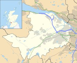
Bishopton is situated in the north east of Renfrewshire. It lies to the south of the River Clyde. The village borders a number of nearby settlements, some separated by a rural hinterland. It is about 5 miles north-west of Paisley and is about 195 feet above sea level.[22] Bishopton has no "Streets" It has Crescents, Roads, Drives, but not any "streets".
Neighbouring towns, villages and places. | ||||||||||
|---|---|---|---|---|---|---|---|---|---|---|
| ||||||||||
Education
Bishopton Primary school is the only school within the village. It is a non-denominational state school. For secondary education the village falls within the catchment area of Park Mains High School in Erskine.
See also
References
- ↑ "Table 2a: Estimated population of settlements by broad age groups, mid-2012" (PDF). Retrieved 3 October 2017.
- ↑ Andy Eagle (27 February 2003). "Leaf through the Online Scots Dictionary". Scots-online.org. Retrieved 25 July 2014.
- ↑ "List of railway station names". Newsnet Scotland. 18 August 2011. Archived from the original on 3 August 2014. Retrieved 25 July 2014.
- ↑ "OS 25 inch 1892-1949". National Library of Scotland. Ordnance Survey. Retrieved 26 October 2017.
- ↑ "Renfrewshire". Cambridge air photos. Retrieved 30 June 2018.
- ↑ Historic Environment Scotland. "Bishopton, Whitemoss (43341)". Canmore. Retrieved 2017-04-02.
- ↑ "Visit Bishopton Roman Fort, Visit Antonine Wall". Scottish Tour Guide's Blog. Retrieved 11 November 2017.
- ↑ "Roy, Highlands, 1747-1752". National Library of Scotland. Ordnance Survey. Retrieved 26 October 2017.
- ↑ "Beyond the Wall". The Antonine Wall. Retrieved 11 November 2017.
- ↑ Newall, Frank (1998). "THE ROMAN FORT ON WHITEMOSS FARM, BISHOPTON, RENFREWSHIRE". Scottish Naturalist. v.110 pt.1: 13–43. Retrieved 1 June 2018.
- ↑ "Bishopton Roman Fort". Roman Britain. Retrieved 11 November 2017.
- ↑ "Search on Bishopton". Hunterian Museum. University of Glasgow. Retrieved 11 November 2017.
- ↑ "Distance Slab of Twentieth Legion, Old Kilpatrick". Retrieved 11 November 2017.
- ↑ "Barochan Hill Roman Fort". Roman Britain. Retrieved 12 November 2017.
- ↑ BAE Systems and Redrow Housing (2006-05-01). "Royal Ordnance Bishopton: Site Gazetteer" (PDF). Renfrewshire Council. Archived from the original (PDF) on 2011-07-22. Retrieved 2009-06-30.
- ↑ The new statistical account of Scotland, Vol VII, Renfrew-Argyle. Edinburgh: W. Blackwood and sons. 1845. p. 523. Retrieved 17 May 2017.
- ↑ Stewart, Robert, Walter (1842). The new statistical account of Scotland (Vol VII ed.). Edinburgh and London: W. Blackwood and Sons. p. 501. Retrieved 11 November 2017.
- ↑ Metcalfe, William Musham (1905). A history of the county of Renfrew from the earliest times. Paisley: A. Gardner. p. 414. Retrieved 16 May 2017.
- 1 2 "Bishopton History: It's been a while". Inbishopton.org.uk. Retrieved 25 July 2014.
- ↑ "Georgetown Filling Factory". Secret Scotland. 1 February 2011. Retrieved 15 July 2014.
- ↑ "Munitions site plan gets go ahead". BBC News. 15 December 2008. Retrieved 13 March 2009.
- ↑ Mort, Frederick (1912). Renfrewshire. Cambridge University Press. p. 61. Retrieved 12 November 2017.
External links
- Map sources for Bishopton, Renfrewshire
| Wikimedia Commons has media related to Bishopton, Renfrewshire. |
- Bishopton's Community Web Site: InBishopton.org.uk
- Bishopton Broncos Basketball Club: Bishoptonbroncos.com
- The Gazette (Local Paper): The-gazette.co.uk