Manteca, California
| City of Manteca | |
|---|---|
| City | |
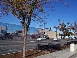 From the corner of Yosemite and Main in Manteca | |
| Nickname(s): The Family City | |
 Location in San Joaquin County and the state of California | |
 City of Manteca Location in the United States | |
| Coordinates: 37°48′10″N 121°13′15″W / 37.80278°N 121.22083°WCoordinates: 37°48′10″N 121°13′15″W / 37.80278°N 121.22083°W | |
| Country |
|
| State |
|
| County | San Joaquin |
| Incorporated | May 28, 1918[1] |
| Government | |
| • Mayor | Stephen DeBrum[2] |
| • State senator | Cathleen Galgiani (D)[3] |
| • Assemblymember | Heath Flora (R)[3] |
| • U. S. rep. | Jeff Denham (R)[4] |
| Area[5] | |
| • Total | 20.57 sq mi (53.28 km2) |
| • Land | 20.55 sq mi (53.22 km2) |
| • Water | 0.02 sq mi (0.06 km2) 0.13% |
| Elevation[6] | 22 ft (11 m) |
| Population (2010)[7] | |
| • Total | 67,096 |
| • Estimate (2016)[8] | 76,908 |
| • Density | 3,743.03/sq mi (1,445.22/km2) |
| Time zone | UTC−8 (Pacific) |
| • Summer (DST) | UTC−7 (PDT) |
| ZIP codes | 95336, 95337 |
| Area code | 209 |
| FIPS code | 06-45484 |
| GNIS feature IDs | 1659046, 2411024 |
| Website |
www |
Manteca is a city in San Joaquin County, California. The city's estimated 2015 US Census population was 75,448.[7][9]
History
Manteca is a city in the Central Valley of California, 76 miles east of San Francisco. It was founded in 1861 by Joshua Cowell. Cowell claimed around 1,000 acres (4.0 km2) and built houses on what is now the corner of Main and Yosemite, where Bank of America now stands. In 1873, the Central Pacific Railroad laid track directly through the area. The residents wanted to refer to their new train station as "Cowell Station", but there was already a Cowell Station near Tracy. The residents agreed to change the name of the community, choosing "Monteca" as the new name.[10] This was misprinted as "Manteca" (Spanish for lard) by the railroad,[10] and the misspelled version was eventually accepted as the name of the town.[11] This misspelling thus became a town joke that would be laughed at throughout generations to come. Bobby and Shirley Davis popularized the pronunciation /mæn'tikə/, even though the Spanish word is pronounced /man'teka/.[12] In 1918, Manteca was incorporated as a city, and Joshua Cowell became its first mayor.
In 1938, photojournalist Dorthea Lange took photos of William & Mary Dimotakis (immigrants from the Greek island of Crete), and their youngest child, son George, on the family farm in Manteca for the Farm Security Administration. The farm, near the industrial park area, is still owned by the Dimotakis family.
Manteca fashions itself the "Family City", and it lies at a crossroads of major highways and railroads. As recently as the 1970s, Manteca existed primarily on agriculture and was still barely a stop between two freeways, Interstate 5 and State Route 99. The continuing rise in Bay Area housing prices caused Bay Area residents to look further eastward for cheaper places to live. Since the construction of the 120 bypass portion of State Route 120, Manteca has become a popular choice for these commuters. The 1990s saw an increase in the city's population and the construction of its third high school, the first two being Manteca High School and East Union High School. The population of Manteca continues to increase, with some housing being constructed on what was once farmland to the north and southeast.
Manteca is the home base for the "Not Forgotten Memorial Day Event", the largest commemoration for veterans on the West Coast. The event is held the Sunday before Memorial Day every year. The event draws over 20,000 attendees.[13]
Geography
According to the United States Census Bureau, the city has a total area of 17.8 square miles (46 km2), 99.87% of it land and 0.13% of it water.
Neighboring towns include Lathrop, Ripon, Escalon, and Tracy. Manteca is located in between the larger cities of Modesto and Stockton.
Climate
According to the Köppen Climate Classification system, Manteca has a warm-summer Mediterranean climate, abbreviated "Csa" on climate maps.[14] It's hot in summer, and mild in winter, except during spells of seasonal tule fog, when it can be quite chilly for many days. Summers are dry, winters are rainy with stretches of fair weather.
Demographics
| Historical population | |||
|---|---|---|---|
| Census | Pop. | %± | |
| 1920 | 1,286 | — | |
| 1930 | 1,614 | 25.5% | |
| 1940 | 1,981 | 22.7% | |
| 1950 | 3,804 | 92.0% | |
| 1960 | 8,242 | 116.7% | |
| 1970 | 13,845 | 68.0% | |
| 1980 | 24,925 | 80.0% | |
| 1990 | 40,773 | 63.6% | |
| 2000 | 49,258 | 20.8% | |
| 2010 | 67,096 | 36.2% | |
| Est. 2016 | 76,908 | [8] | 14.6% |
| U.S. Decennial Census[15] | |||
2010
The 2010 United States Census[16] reported that Manteca had a population of 67,096. The population density was 3,778.5 per square mile (1,458.9/km²). The racial makeup of Manteca was 49.6% White, 9.8% African American, 1.1% Native American, 12.1% Asian,0.6% Pacific Islander, 11.4% from other races, and 7.2% from two or more races. Hispanic or Latino of any race were 43.7%.
The Census reported that 66,601 people (99.3% of the population) lived in households, 150 (0.2%) lived in non-institutionalized group quarters, and 345 (0.5%) were institutionalized.
There were 21,618 households, of which 9,681 (44.8%) had children under the age of 18 living in them, 11,973 (55.4%) were opposite-sex married couples living together, 3,009 (13.9%) had a female householder with no husband present, 1,590 (7.4%) had a male householder with no wife present. There were 1,629 (7.5%) unmarried opposite-sex partnerships and 130 (0.6%) same-sex married couples or partnerships. 3,902 households (18.0%) were made up of individuals and 1,542 (7.1%) had someone living alone who was 65 years of age or older. The average household size was 3.08. There were 16,572 families (76.7% of all households); the average family size was 3.48.
19,432 people (29.0% of the population) were under the age of 18, 6,569 people (9.8%) aged 18 to 24, 18,075 people (26.9%) aged 25 to 44, 16,367 people (24.4%) aged 45 to 64, and 6,653 people (9.9%) who were 65 years of age or older. The median age was 33.6 years. For every 100 females, there were 96.8 males. For every 100 females age 18 and over, there were 93.6 males.
There were 23,132 housing units at an average density of 1,302.7 per square mile (503.0/km²), of which 13,521 (62.5%) were owner-occupied, and 8,097 (37.5%) were occupied by renters. The homeowner vacancy rate was 2.7%; the rental vacancy rate was 6.5%. 41,225 people (61.4% of the population) lived in owner-occupied housing units and 25,376 people (37.8%) lived in rental housing units.
2000
At the 2000 census,[17] there were 49,258 people, 16,368 households and 12,488 families residing in the city. The population density was 1,195.4/km² (3,095.8/mi²). There were 16,937 housing units at an average density of 411.0/km² (1,064.5/mi²). The racial makeup of the city was 74.17% White, 2.85% African American, 1.31% Native American, 3.52% Asian, 0.36% Pacific Islander, 11.56% from other races, and 6.23% from two or more races. 25.10% of the population were Hispanic or Latino of any race.
There were 16,368 households of which 43.3% had children under the age of 18 living with them, 57.2% were married couples living together, 13.0% had a female householder with no husband present, and 23.7% were non-families. 18.6% of all households were made up of individuals and 7.1% had someone living alone who was 65 years of age or older. The average household size was 2.98 and the average family size was 3.39.
31.6% of the population were under the age of 18, 8.8% from 18 to 24, 30.5% from 25 to 44, 19.8% from 45 to 64, and 9.3% who were 65 years of age or older. The median age was 32 years. For every 100 females, there were 96.3 males. For every 100 females age 18 and over, there were 92.9 males.
The median household income was $46,677 and the median family income was $51,587. Males had a median income of $43,283 compared with $27,772 for females. The per capita income for the city was $18,241. 9.7% of the population and 7.2% of families were below the poverty line. 10.7% of those under the age of 18 and 6.4% of those 65 and older were living below the poverty line.
Economy
Top employers
According to the City's 2011 Comprehensive Annual Financial Report,[18] the top employers in the city were:
| Employer | No. of employees |
|---|---|
| Manteca Unified School District | 1,350 |
| Kaiser Permanente | 590 |
| Doctors Hospital of Manteca | 370 |
| City of Manteca | 391 |
| Wal-Mart | 301 |
| Eckert Cold Storage | 300 |
| APDS Logistics | 200 |
| Costco | 169 |
| Target | 151 |
Transit
Bus service in Manteca is provided by Manteca Transit.
A regional rail service for commuters to San Jose is provided by the Altamont Corridor Express (ACE) at the Lathrop/Manteca station.
Schools
Public schools in Manteca are part of the Manteca Unified School District. The school district encompasses the towns of Manteca, Lathrop, the community of French Camp, and the Weston Ranch community in Stockton. There are no middle schools; elementary school continues through the 8th grade, with a mix of both year-round and traditional schools. Manteca Unified School District has 19 elementary schools, 5 high schools, and 2 continuation schools. Not all of the schools listed below are in Manteca itself.
High schools
- Calla High School
- East Union High School
- Manteca High School
- Sierra High School
- Weston Ranch High School
- New Vision High School (continuation)
- Lathrop High School
- Be.Tech High School and Career Academy
Elementary schools
- August Knodt
- Brock Elliott
- French Camp
- George Komure
- George McParland
- james Cameron
- Great Valley(Salida)
- Joseph Widmer Jr
- Joshua Cowell
- Lathrop
- Lincoln
- Mossdale Elementary
- Neil Hafley
- New Haven
- Nile Garden
- Sequoia
- Shasta
- Stella Brockman
- Veritas
- Walter E. Woodward
- Alta Vista (private)
- St. Anthony's (private)
Adult schools
Notable people from Manteca
- Sheila Bleck (b. 1974) – IFBB professional bodybuilder
- Gilbert Luján (b.1940 – d. 2011) – sculptor, painter
- Justin Roiland (b. 1980) – cartoon creator and voice actor
- Scott Brooks (b. 1965) – former NBA basketball player and current head coach; attended East Union High School
- Sammy L. Davis – Medal of Honor recipient
- Marliece Andrada (b. 1972) – actress and Playboy's Playmate of the Month in March 1998
- Ernie Barber (b. 1914 – d. 1989) – former NFL player for the Washington Redskins
- April Bowlby (b. 1980) – actress
- Milo Candini (b. 1917 – d. 1998)[19] – Major League Baseball player 1943–51
- Scott Speed (b. 1983) – race car driver
- Dev (b. 1989) – singer songwriter
- Doug Mikolas (b. 1961) – football player
References
- ↑ "California Cities by Incorporation Date". California Association of Local Agency Formation Commissions. Archived from the original (Word) on November 3, 2014. Retrieved August 25, 2014.
- ↑ "Mayor and Council". City of Manteca. Retrieved February 2, 2015.
- 1 2 "Statewide Database". UC Regents. Retrieved November 21, 2014.
- ↑ "California's 10th Congressional District - Representatives & District Map". Civic Impulse, LLC.
- ↑ "2016 U.S. Gazetteer Files". United States Census Bureau. Retrieved Jun 28, 2017.
- ↑ "Manteca". Geographic Names Information System. United States Geological Survey. Retrieved February 2, 2015.
- 1 2 "Manteca (city) QuickFacts". United States Census Bureau. Archived from the original on February 15, 2015. Retrieved February 11, 2015.
- 1 2 "Population and Housing Unit Estimates". Retrieved June 9, 2017.
- ↑ "Population estimates, July 1, 2015, (V2015)". www.census.gov. Retrieved 2017-05-22.
- 1 2 Manteca Chamber of Commerce: http://manteca.org/about-manteca/
- ↑ "Manteca, California Historical Society". Archived from the original on August 6, 2004. Retrieved March 29, 2018.
- ↑ "Take the test: Are you a Man-tee-kan!". Retrieved March 29, 2018.
- ↑ http://www.thememorialweekend.org/index.php/our-mission%5Bpermanent+dead+link%5D
- ↑ "Manteca, California Köppen Climate Classification (Weatherbase)". Weatherbase. Retrieved March 29, 2018.
- ↑ "Census of Population and Housing". Census.gov. Retrieved June 4, 2015.
- ↑ "2010 Census Interactive Population Search: CA – Manteca city". U.S. Census Bureau. Retrieved July 12, 2014.
- ↑ "American FactFinder". United States Census Bureau. Retrieved 2008-01-31.
- ↑ "City of Manteca CAFR" (PDF). Archived from the original (PDF) on August 3, 2016. Retrieved March 29, 2018.
- ↑ "Milo Candini Stats - Baseball-Reference.com". Baseball-Reference.com. Retrieved March 29, 2018.
External links
| Wikimedia Commons has media related to Manteca, California. |
| Wikivoyage has a travel guide for Manteca. |
- Official website

- Manteca Convention and Visitors Bureau
- Manteca Chamber of Commerce
- Manteca Unified School District
- Manteca, California at Curlie (based on DMOZ)
Municipalities and communities of San Joaquin County, California, United States | ||
|---|---|---|
| Cities | 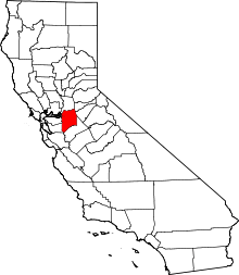 | |
| CDPs | ||
| Unincorporated communities | ||
| Ghost towns |
| |