Ridgecrest, California
| Ridgecrest, California | ||
|---|---|---|
| City | ||
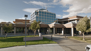
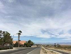 College Heights Blvd., Ridgecrest | ||
| ||
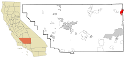 Location in Kern County and the state of California | ||
 Ridgecrest, California Location in the United States | ||
| Coordinates: 35°37′21″N 117°40′15″W / 35.62250°N 117.67083°WCoordinates: 35°37′21″N 117°40′15″W / 35.62250°N 117.67083°W | ||
| Country |
| |
| State |
| |
| County | Kern | |
| Incorporated | November 29, 1963[1] | |
| Government | ||
| • Mayor | Peggy Breeden[2] | |
| • State senator | Jean Fuller (R)[3] | |
| • Assemblymember | Vince Fong (R)[4] | |
| • U. S. rep. | Kevin McCarthy (R)[5] | |
| Area[6] | ||
| • Total | 21.53 sq mi (55.76 km2) | |
| • Land | 20.88 sq mi (54.08 km2) | |
| • Water | 0.65 sq mi (1.69 km2) 3.04% | |
| Elevation[7] | 2,290 ft (698 m) | |
| Population (2010) | ||
| • Total | 27,616 | |
| • Estimate (2017)[8] | 28,880 | |
| • Density | 1,374.57/sq mi (530.72/km2) | |
| Time zone | UTC−8 (Pacific) | |
| • Summer (DST) | UTC−7 (PDT) | |
| ZIP codes | 93555–93556 | |
| Area codes | 442/760 | |
| FIPS code | 06-60704 | |
| GNIS feature IDs | 1652783, 2410944 | |
| Website |
www | |
Ridgecrest is a city in Kern County, California, United States. It is located along U.S. Route 395 in the Indian Wells Valley in northeastern Kern County, adjacent to the Naval Air Weapons Station China Lake (NAWS, or China Lake). The population was 27,616 at the 2010 census, up from 24,927 at the 2000 census. It was incorporated as a city in 1963.
Ridgecrest is surrounded by four mountain ranges; the Sierra Nevada on the west, the Cosos on the north, the Argus Range on the east, and the El Paso Mountains on the south. It is approximately 82 miles (132 km) from the Lancaster/Palmdale area, 110 miles (177 km) from Bakersfield, and 120 miles (193 km) from San Bernardino, the three nearest major urban centers. Private air travel in and out of the city is provided through the Inyokern Airport. There are currently no scheduled commercial flights in or out of Ridgecrest.
Ridgecrest is within two hours of the highest and the lowest points in the contiguous U.S.[9]
History
The settlement began as a farming community called Crumville in 1912,[10] honoring James and Robert Crum, local dairymen.[10] The first post office opened in 1941. By 1943, Ridgecrest had grown to 115 homes and 196 residents. NOTS (Naval Ordnance Test Station) was established in November 1943, providing a strong job base for the years to come.[10]
Ridgecrest incorporated in 1963.[10] During this era the growth of Ridgecrest was governed by the continuing needs of the high tech industries coupled to the Naval Station's programs for testing arms and guidance systems.
Geography
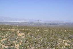
According to the United States Census Bureau, the city has a total area of 21.4 square miles (55.4 km2), of which 20.8 sq mi (53.9 km2) is land and 0.7 sq mi (1.8 km2) of it (3.04%) is water. Ridgecrest is located in Indian Wells Valley, which is a southern extension of Owens Valley, broken up by the volcanic Coso Range.
1995 Ridgecrest earthquake
The area, associated with the Eastern California Shear Zone, has experienced numerous earthquake swarms in the past (groups of several thousand quakes under magnitude 6.0 or so) often with no obvious mainshock. The 1995 Ridgecrest earthquake sequence started on August 17, when a magnitude 5.4 quake, centered 18 kilometers (11 mi) north of the town of Ridgecrest, shook the area and spawned over 2,500 aftershocks over the course of the following five weeks. Then, on September 20, 1995, the second large quake struck the area: it measured magnitude 5.8, and was at that time the largest earthquake to hit southern California since the January 17, 1994 Northridge earthquake.[11]
Climate
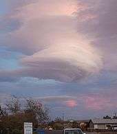
The weather in the Indian Wells Valley is predominantly influenced by its high desert location. The climate is characterized by hot days and cool nights with extremely arid conditions prevailing throughout the summer months. The mean annual maximum temperature for the Ridgecrest area is 75 °F (24 °C) while the mean annual minimum temperature is 48 °F (9 °C). There are wide annual temperature fluctuations that occur from a high of 119 °F (48 °C) to a low of 1 °F (−17 °C). The area is known to have wind as high as 75 mph (121 km/h) on a sunny day. Whenever winds exceed 30 mph (48 km/h) dust devils and dust clouds form in the area. December is the coolest month with an average maximum temperature of 60 °F (16 °C) and an average minimum temperature of 30 °F (−1 °C). The all-time minimum temperature of 1 °F (−17 °C) was recorded on December 23, 1963, and January 7, 1973. Ridgecrest is a desert, with an average of less than 5 inches (130 mm) "equivalent rainfall" per year, which includes less than 2 inches (51 mm) of snow.
July is the hottest month with an average maximum temperature of 103 °F (39 °C) and an average minimum temperature of 66 °F (19 °C). The all-time maximum temperature of 119 °F (48 °C) was recorded on July 31, 1971.
| Climate data for Naval Air Weapons Station China Lake | |||||||||||||
|---|---|---|---|---|---|---|---|---|---|---|---|---|---|
| Month | Jan | Feb | Mar | Apr | May | Jun | Jul | Aug | Sep | Oct | Nov | Dec | Year |
| Record high °F (°C) | 78 (26) |
89 (32) |
92 (33) |
104 (40) |
108 (42) |
118 (48) |
119 (48) |
114 (46) |
109 (43) |
103 (39) |
89 (32) |
77 (25) |
119 (48) |
| Average high °F (°C) | 61.3 (16.3) |
63.7 (17.6) |
74.4 (23.6) |
76.1 (24.5) |
85.9 (29.9) |
98.2 (36.8) |
101.8 (38.8) |
101.9 (38.8) |
94.3 (34.6) |
81.2 (27.3) |
64.3 (17.9) |
58.5 (14.7) |
80.1 (26.7) |
| Average low °F (°C) | 30.6 (−0.8) |
34.6 (1.4) |
40.1 (4.5) |
45.6 (7.6) |
52.8 (11.6) |
63.1 (17.3) |
68.4 (20.2) |
67.4 (19.7) |
59.4 (15.2) |
48.3 (9.1) |
33.8 (1) |
26.1 (−3.3) |
47.5 (8.6) |
| Record low °F (°C) | 6 (−14) |
12 (−11) |
21 (−6) |
27 (−3) |
38 (3) |
42 (6) |
50 (10) |
51 (11) |
39 (4) |
24 (−4) |
18 (−8) |
8 (−13) |
6 (−14) |
| Average precipitation inches (mm) | 0.88 (22.4) |
0.79 (20.1) |
0.78 (19.8) |
0.13 (3.3) |
0.11 (2.8) |
0.02 (0.5) |
0.09 (2.3) |
0.31 (7.9) |
0.24 (6.1) |
0.18 (4.6) |
0.27 (6.9) |
0.47 (11.9) |
4.27 (108.6) |
| Average snowfall inches (cm) | 0.8 (2) |
0.0 (0) |
0.0 (0) |
0.0 (0) |
0.0 (0) |
0.0 (0) |
0.0 (0) |
0.0 (0) |
0.0 (0) |
0.0 (0) |
0.0 (0) |
0.5 (1.3) |
1.3 (3.3) |
| Source: [12] | |||||||||||||
| Climate data for Inyokern, California | |||||||||||||
|---|---|---|---|---|---|---|---|---|---|---|---|---|---|
| Month | Jan | Feb | Mar | Apr | May | Jun | Jul | Aug | Sep | Oct | Nov | Dec | Year |
| Record high °F (°C) | 80 (27) |
86 (30) |
93 (34) |
100 (38) |
112 (44) |
114 (46) |
119 (48) |
114 (46) |
110 (43) |
105 (41) |
88 (31) |
84 (29) |
119 (48) |
| Average high °F (°C) | 59.6 (15.3) |
64.8 (18.2) |
70.3 (21.3) |
77.7 (25.4) |
87.0 (30.6) |
96.7 (35.9) |
102.7 (39.3) |
101.2 (38.4) |
94.2 (34.6) |
83.2 (28.4) |
69.0 (20.6) |
59.7 (15.4) |
80.5 (27) |
| Average low °F (°C) | 30.8 (−0.7) |
34.6 (1.4) |
38.7 (3.7) |
44.3 (6.8) |
52.9 (11.6) |
60.5 (15.8) |
66.2 (19) |
64.6 (18.1) |
58.1 (14.5) |
48.2 (9) |
37.3 (2.9) |
30.2 (−1) |
47.2 (8.4) |
| Record low °F (°C) | 1 (−17) |
9 (−13) |
15 (−9) |
21 (−6) |
26 (−3) |
38 (3) |
46 (8) |
45 (7) |
35 (2) |
20 (−7) |
14 (−10) |
5 (−15) |
1 (−17) |
| Average precipitation inches (mm) | 0.74 (18.8) |
0.95 (24.1) |
0.55 (14) |
0.17 (4.3) |
0.07 (1.8) |
0.02 (0.5) |
0.16 (4.1) |
0.22 (5.6) |
0.20 (5.1) |
0.10 (2.5) |
0.38 (9.7) |
0.59 (15) |
4.15 (105.5) |
| Average snowfall inches (cm) | 0.3 (0.8) |
0.0 (0) |
0.1 (0.3) |
0.0 (0) |
0.0 (0) |
0.0 (0) |
0.0 (0) |
0.0 (0) |
0.0 (0) |
0.0 (0) |
0.0 (0) |
0.2 (0.5) |
0.6 (1.6) |
| Source: [13] | |||||||||||||
Demographics
| Historical population | |||
|---|---|---|---|
| Census | Pop. | %± | |
| 1950 | 2,028 | — | |
| 1960 | 5,099 | 151.4% | |
| 1970 | 7,629 | 49.6% | |
| 1980 | 15,929 | 108.8% | |
| 1990 | 27,725 | 74.1% | |
| 2000 | 24,927 | −10.1% | |
| 2010 | 27,616 | 10.8% | |
| Est. 2017 | 28,880 | [8] | 4.6% |
| U.S. Decennial Census[14] | |||
2010
The 2010 United States Census[15] reported that Ridgecrest had a population of 27,616. The population density was 1,289.5 people per square mile (497.9/km²). The racial makeup of Ridgecrest was 21,387 (77.4%) White, 1,113 (4.0%) African American, 341 (1.2%) Native American, 1,209 (4.4%) Asian, 143 (0.5%) Pacific Islander, 1,836 (6.6%) from other races, and 1,587 (5.7%) from two or more races. Hispanic or Latino of any race were 4,941 persons (17.9%).
The Census reported that 27,420 people (99.3% of the population) lived in households, 109 (0.4%) lived in non-institutionalized group quarters, and 87 (0.3%) were institutionalized.
There were 10,781 households, out of which 3,901 (36.2%) had children under the age of 18 living in them, 5,211 (48.3%) were opposite-sex married couples living together, 1,352 (12.5%) had a female householder with no husband present, 609 (5.6%) had a male householder with no wife present. There were 681 (6.3%) unmarried opposite-sex partnerships, and 64 (0.6%) same-sex married couples or partnerships. 2,978 households (27.6%) were made up of individuals and 1,001 (9.3%) had someone living alone who was 65 years of age or older. The average household size was 2.54. There were 7,172 families (66.5% of all households); the average family size was 3.10.
The population was spread out with 7,544 people (27.3%) under the age of 18, 2,654 people (9.6%) aged 18 to 24, 7,157 people (25.9%) aged 25 to 44, 6,844 people (24.8%) aged 45 to 64, and 3,417 people (12.4%) who were 65 years of age or older. The median age was 33.8 years. For every 100 females, there were 100.3 males. For every 100 females age 18 and over, there were 99.9 males.
There were 11,915 housing units at an average density of 556.3 per square mile (214.8/km²), of which 6,525 (60.5%) were owner-occupied, and 4,256 (39.5%) were occupied by renters. The homeowner vacancy rate was 2.9%; the rental vacancy rate was 9.2%. 16,520 people (59.8% of the population) lived in owner-occupied housing units and 10,900 people (39.5%) lived in rental housing units.
2000
According to the census[16] of 2000, there were 24,927 people, 9,826 households, and 6,691 families residing in the city. The population density was 1,179.9 inhabitants per square mile (455.6/km2). There were 11,309 housing units at an average density of 535.3/sq mi (206.7/km2). The racial makeup of the city was 82.02% White, 3.53% Black or African American, 1.08% Native American, 3.88% Asian, 0.58% Pacific Islander, 4.93% from other races, and 3.98% from two or more races. 12.04% of the population were Hispanic or Latino of any race.
There were 9,826 households out of which 35.0% had children under the age of 18 living with them, 52.2% were married couples living together, 11.5% had a female householder with no husband present, and 31.9% were non-families. 27.6% of all households were made up of individuals and 8.6% had someone living alone who was 65 years of age or older. The average household size was 2.51 and the average family size was 3.06.
In the city, the population was spread out with 29.1% under the age of 18, 8.5% from 18 to 24, 28.1% from 25 to 44, 23.0% from 45 to 64, and 11.3% who were 65 years of age or older. The median age was 36 years. For every 100 females, there were 99.6 males. For every 100 females age 18 and over, there were 97.9 males.
The median income for a household in the city was $44,971, and the median income for a family was $52,725. Males had a median income of $46,993 versus $29,558 for females. The per capita income for the city was $21,312. About 10.2% of families and 12.3% of the population were below the poverty line, including 17.5% of those under age 18 and 5.1% of those age 65 or over.
|
|
|
|
People in group quarters:[17]
- 987 people in military barracks, etc.
- 87 people in nursing homes
- 33 people in other non-institutional group quarters
- 22 people in state prisons
Local features and activities

The most notable feature in the nearby area is the Coso People rock art in Big and Little Petroglyph Canyons. The Coso People were prolific artists and traded with distant tribes using tools crafted of stone. Archeological recovery at coastal Chumash sites in California indicates considerable trade with the Coso People.[18]
Other traditional activities present are:
|
Maturango Museum

The Maturango Museum is located in Ridgecrest. The museum is best known for the guided tours to Little Petroglyph Canyon on China Lake Naval Weapons Station (NAWS).[19] The museum offers exhibits and displays featuring both the natural and the cultural history and diversity of the Northern Mojave Desert with exhibits of plants, animals, Native American artifacts, geology and contemporary arts and crafts.[20]
Naval Air Weapons Station
Naval Air Weapons Station China Lake or NAWS China Lake is an airborne weapons testing and training range located adjacent to Ridgecrest and operated by the United States Navy and its contractors.
Coso Rock Art District
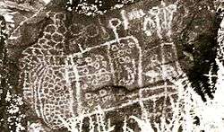
Coso Rock Art District, sometimes equated with the Big and Little Petroglyph Canyons is a site containing over 20,000 Native American petroglyphs[21] now located within Naval Air Weapons Station China Lake, near China Lake and Ridgecrest, California. In fact, there are several other distinct canyons to the Coso Rock Art District besides the Big and Little Petroglyph Canyons. The most popular subjects are bighorn sheep, deer, and antelope. Big and Little Petroglyph Canyons were declared a National Historic Landmark in 1964. In 2001, they were incorporated into a larger National Historic Landmark District, called Coso Rock Art District. In 2014, the Ridgecrest Petroglyph Festival, a celebration of the petroglyphs, native culture, and Ridgecrest as a California tourist destination was created as an annual event. It was named as one of Groupon's "10 Most Unique Autumn Festivals in the Country"[22]
Walker Pass
Walker Pass (elevation 5,250 ft (1.60 km)) is a mountain pass by Lake Isabella in the southern Sierra Nevada mountains. It is located in northeastern Kern County, approximately 53 mi (85 km) ENE of Bakersfield and 10 mi (16 km) WSW of Ridgecrest. The pass provides a route between the San Joaquin Valley on the west and the Mojave Desert on the east.
Events calendar
Source:[23]
- Annually in September: Parade of 1,000 flags for Sept. 11, 2001 terrorist attacks.[24] (memorial service)
- Annually in November: Ridgecrest Petroglyph Festival[25]
- Annually in spring: Wildflower Tours
- Annually in spring & fall: Petroglyph Tours
- Annually in October: Desert Empire Fair
- Annually in November: Gem and Mineral Show
- Annually in December: Santa's Art Shop
Education
Sierra Sands Unified School District[26] includes the following elementary schools: Las Flores Elementary currently displaced to Vieweg Elementary, Faller Elementary, Richmond Elementary, Gateway Elementary, Pierce Elementary, and Inyokern Elementary. For middle-schoolers the school district includes James Monroe Middle School, and Murray Middle School. The district's primary high school, Sherman E Burroughs High School, serves Ridgecrest, China Lake NAWC, Inyokern, Buttermilk Acres, Red Mountain, and Randsburg. There is also an alternative high school, Mesquite High School.[27] Ridgecrest Charter School is a tuition-free public school supported by the California State Board of Education. Opened in 2001, the school educates children from Transitional K to the 8th grade. It is the only public school in Ridgecrest that combines both elementary and junior high.
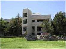
College
Cerro Coso Community College was established in 1973 and has a full-time enrollment of 2,347.[28] The 420 acres (1.7 km2) Indian Wells Valley Campus (IWV) is located in the upper Mojave Desert near Ridgecrest.[29] The IWV Campus is the largest of the Cerro Coso campuses. It serves a population of about 50,000. The College serves the communities of Ridgecrest, China Lake, Inyokern, and Trona.
Public library
Ridgecrest Branch Library, a branch of the Kern County Library, serves Ridgecrest, Inyokern, China Lake, Trona and surrounding communities. Obtaining funding to run the library has been difficult in recent years, due in part to the recession and cuts in the county budget.
Public safety
Ridgecrest has its own police department, as well as a regional station of the Kern County Sheriff's Department. The Kern County Fire Department[30] provides fire protection and emergency medical services. Full-time law enforcement employees in 2008 numbered 56 (41 officers).
Crime statistics for 2011 (reported by the Ridgecrest Police Department):[31]
|
Notable natives and residents
Notable natives include:
- Rebekka Armstrong, Playboy Playmate and HIV/AIDS activist[32]
- Mark Hoppus, musician, from the rock band Blink-182[33][34]
- Lacy Barnes-Mileham, (b. 1964), graduated Burroughs High (1983) and Fresno State (1988). Won U.S.A. Track and Field discus championships in 1999 and 1991, and competed in the 1996 Atlanta Olympics.
Media
Ridgecrest has one TV station, KZGN-LD, owned by Wiknich Broadcasting Corp., that has 3 channels serving the entire Indian Wells Valley over the air and on Mediacom Cable. KZGN provides local news, weather and sports. KZGN also provides a local interview program, Ridgecrest Talk, daily as well. Ridgecrest is served by two newspapers, The Daily Independent and the News Review, as well as a mixture of local broadcast stations and repeaters from radio and TV stations based in Los Angeles and Bakersfield. The repeaters are operated by the IWV TV Booster. Radio stations in the area include KZFX 93.7 a classic rock format with ABC and California news and weather; KSSI (FM) 102.7, broadcasting rock music, local news and weather; KLOA (AM) 1240, broadcasting an oldies format; KZIQ 92.7, featuring adult contemporary music; KRAJ The Heat 100.9 fm, featuring a hip-hop party rock format; and K296AI the 107.1, with KCNV classical music feed. KRCK, "Ridgecrest Radio", went off the air in the 1970s. TV repeater K05FO 5 rebroadcasts KTLA; K35HO-D 35 rebroadcasts KBAK.
| Translator Call Letters | B Mountain Channel | Laurel Mountain Channel | PSIP | Station Call Letters | Network Affiliation ID | Original Channel | Signal Quality |
|---|---|---|---|---|---|---|---|
| K02HY | 2 | N/A | N/A | KCBS-TV | CBS | 43.1, Los Angeles | Good |
| K04HX | 4 | N/A | N/A | KNBC | NBC | 36.1, Los Angeles | Good |
| K05FO | 5 | N/A | N/A | KTLA | CW | 31.1, Los Angeles | Good |
| K07NH | 7 | N/A | N/A | KABC-TV | ABC | 7.1, Los Angeles | Good |
| K09MG | 9 | N/A | N/A | KCAL-TV | Ind. | 9.1, Los Angeles | Good |
| K11ML | 11 | N/A | N/A | KTTV | Fox | 11.1, Los Angeles | Good |
| K13NF | 13 | N/A | N/A | KCOP | MyNetwork TV | 13.1, Los Angeles | Good |
| K14AT-D | N/A | 14 | 64 | KHIZ | Ind | 44, Barstow | Good |
| K15HJ-D | N/A | 15 | 2 | KCBS-DT | CBS | 43, Los Angeles | Off air, dead power supply in transmitter |
| K17HY-D | N/A | 17 | 4 | KNBC-DT | NBC | 36, Los Angeles | Good |
| K41GO | N/A | 19 | N/A | N/A | N/A | N/A | Not in service |
| K20LH-D | N/A | 20 | N/A | N/A | N/A | N/A | Not in service |
| K21IN-D | N/A | 21 | 5 | KTLA-DT | CW | 31, Los Angeles | Good |
| K23IS-D | N/A | 23 | 7 | KABC-DT | ABC | 7, Los Angeles | Good |
| K33ID-D | N/A | 33 | N/A | N/A | N/A | N/A | Not in service |
| K35HO-D | N/A | 35 | 41 | K41GO | City | 41, Ridgecrest | Good |
| K39HT-D | N/A | 39 | 58 | KLCS-DT | PBS | 41, Los Angeles | Good |
| K45GQ-D | N/A | 45 | 9 | KCAL-DT | Ind. | 9, Los Angeles | Good |
| K47AE-D | N/A | 47 | 11 | KTTV-DT | Fox | 11, Los Angeles | Good |
| K49AA-D | N/A | 49 | 13 | KCOP-DT | MyNetwork TV | 13, Los Angeles | Good |
| K51DD-D | N/A | 51 | 28 | KCET-DT | Ind. Public TV | 28, Los Angeles | Good |
See also
References
- ↑ "California Cities by Incorporation Date" (Word). California Association of Local Agency Formation Commissions. Retrieved April 12, 2013.
- ↑ "Ridgecrest City Council". City of Ridgecrest. Retrieved January 31, 2015.
- ↑ "Senators". State of California. Retrieved April 12, 2013.
- ↑ "Members Assembly". State of California. Retrieved April 12, 2013.
- ↑ "California's 23rd Congressional District - Representatives & District Map". Civic Impulse, LLC. Retrieved April 12, 2013.
- ↑ "2016 U.S. Gazetteer Files". United States Census Bureau. Retrieved Jun 28, 2017.
- ↑ "Ridgecrest". Geographic Names Information System. United States Geological Survey.
- 1 2 "Population and Housing Unit Estimates". Retrieved August 30, 2018.
- ↑ "CITY OF RIDGECREST, CA". analyzed data. Retrieved 2009-06-24.
- 1 2 3 4 Durham, David L. (1998). California's Geographic Names: A Gazetteer of Historic and Modern Names of the State. Clovis, Calif.: Word Dancer Press. p. 1096. ISBN 1-884995-14-4.
- ↑ "Ridgecrest Earthquake". Southern California Earthquake Data Center. Retrieved 20 October 2016.
- ↑ "CHINA LAKE NAF, CALIFORNIA (041733)". Western Regional Climate Center. Retrieved June 4, 2016.
- ↑ "INYOKERN, CALIFORNIA (044278)". Western Regional Climate Center. Retrieved June 2, 2016.
- ↑ "Census of Population and Housing". Census.gov. Archived from the original on May 11, 2015. Retrieved June 4, 2015.
- ↑ "2010 Census Interactive Population Search: CA - Ridgecrest city". U.S. Census Bureau. Retrieved July 12, 2014.
- ↑ "American FactFinder". United States Census Bureau. Archived from the original on September 11, 2013. Retrieved 2008-01-31.
- ↑ "City-data – People in group quarters / Ridgecrest, California". analyzed data from numerous sources. Retrieved 2009-03-07.
- ↑ The Megalithic Portal and Megalith Map. "C.Michael Hogan (2008) ''Morro Creek'', ed. by A. Burnham". Megalithic.co.uk. Retrieved 2011-11-05.
- ↑ "Maturango Museum Home Page". Retrieved 2009-03-28.
- ↑ "The Maturango Museum". data from Desert USA. Retrieved 2009-03-28.
- ↑ "Coso Rock Art District". National Historic Landmarks Quioklinks. National Park Service. Retrieved 18 March 2012.
- ↑ "Fall Festivals: The 10 Most Unusual Fests Across the Country". Groupon. Retrieved 2015-09-02.
- ↑ "DesertUSA – Events Calendar for Ridgecrest, Ca". comprehensive resource about the North American deserts. Retrieved 2009-03-21.
- ↑ "9/11 Parade of 1,000 flags". Ridgecrest Daily Independent. Retrieved 2009-09-13.
- ↑ "2016 Ridgecrest Petroglyph Festival". Retrieved 2014-10-10.
- ↑ "Sierra Sands Unified School District". Retrieved 2009-03-10.
- ↑ "Mesquite High School". Retrieved 2009-03-11.
- ↑ "Cerro Coso Community College – Main website". Retrieved 2009-03-25.
- ↑ "Indian Wells Valley Campus". Retrieved 2009-03-25.
- ↑ "Kern County Fire Department". Retrieved 2009-03-10.
- ↑ "Uncategorised - City of Ridgecrest".
- ↑ Jerome, Richard (April 7, 1997). "Object Lesson". People. 47 (13). Retrieved April 10, 2012.
- ↑ Binelli, Mark (September 16, 1999), "Q&A: Blink-182's Mark Hoppus", Rolling Stone (821), retrieved June 27, 2012
- ↑ "Mark Hoppus: Biography, Latest News & Videos". TV Guide. Retrieved June 27, 2012.
External links
| Wikimedia Commons has media related to Ridgecrest, California. |
| Wikivoyage has a travel guide for Ridgecrest. |
- Official City of Ridgecrest website
- City-data.com: Ridgecrest, California
- USGS.gov: Recent Earthquakes in Ridgecrest, California
