Lincoln County, Tennessee
| Lincoln County, Tennessee | ||
|---|---|---|
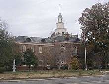 Lincoln County Courthouse in Fayetteville | ||
| ||
|
Location in the U.S. state of Tennessee | ||
 Tennessee's location in the U.S. | ||
| Founded | 1809 | |
| Named for | Benjamin Lincoln[1] | |
| Seat | Fayetteville | |
| Largest city | Fayetteville | |
| Area | ||
| • Total | 571 sq mi (1,479 km2) | |
| • Land | 570 sq mi (1,476 km2) | |
| • Water | 0.4 sq mi (1 km2), 0.07% | |
| Population | ||
| • (2015) | 33,743 | |
| • Density | 58/sq mi (22/km2) | |
| Congressional district | 4th | |
| Time zone | Central: UTC−6/−5 | |
| Website |
www | |

Lincoln County is a county located in the U.S. state of Tennessee. As of the 2010 census, the population was 33,361.[2] Its county seat and largest city is Fayetteville.[3] The county is named for Major General Benjamin Lincoln, an officer in the American Revolutionary War.[4]
History
Lincoln County was created in 1809 from parts of Bedford County. The land occupied by the county was part of a land session obtained from the Cherokee and Chickasaw in 1806.[1]
The Lincoln County Process, used in the distillation of Tennessee whiskey, is named for this county, as the Jack Daniel Distillery was located there. However, a subsequent redrawing of county lines resulted in the establishment of adjacent Moore County, which includes the location of the distillery. Another distillery opened in Lincoln County in 1997 – the Benjamin Pritchard's Distillery. However, it did not use the Lincoln County Process for making its Tennessee whiskey. When a law was established in 2013 to require the Lincoln County Process to be used for making all Tennessee whiskey, the Benjamin Pritchard's Distillery was exempted by a grandfather clause, so no current Lincoln County business uses its namesake process.
Geography
According to the U.S. Census Bureau, the county has a total area of 571 square miles (1,480 km2), of which 570 square miles (1,500 km2) is land and 0.4 square miles (1.0 km2) (0.07%) is water.[5]
Adjacent counties
- Bedford County (north)
- Moore County (northeast)
- Franklin County (east)
- Madison County, Alabama (south)
- Limestone County, Alabama (southwest)
- Giles County (west)
- Marshall County (northwest)
State protected areas
- Flintville Hatchery Wildlife Management Area
Demographics
| Historical population | |||
|---|---|---|---|
| Census | Pop. | %± | |
| 1810 | 6,104 | — | |
| 1820 | 14,761 | 141.8% | |
| 1830 | 22,075 | 49.5% | |
| 1840 | 21,493 | −2.6% | |
| 1850 | 23,492 | 9.3% | |
| 1860 | 22,828 | −2.8% | |
| 1870 | 28,050 | 22.9% | |
| 1880 | 26,960 | −3.9% | |
| 1890 | 27,382 | 1.6% | |
| 1900 | 26,304 | −3.9% | |
| 1910 | 25,908 | −1.5% | |
| 1920 | 25,786 | −0.5% | |
| 1930 | 25,422 | −1.4% | |
| 1940 | 27,214 | 7.0% | |
| 1950 | 25,624 | −5.8% | |
| 1960 | 23,829 | −7.0% | |
| 1970 | 24,318 | 2.1% | |
| 1980 | 26,483 | 8.9% | |
| 1990 | 28,157 | 6.3% | |
| 2000 | 31,340 | 11.3% | |
| 2010 | 33,361 | 6.4% | |
| Est. 2016 | 33,645 | [6] | 0.9% |
| U.S. Decennial Census[7] 1790-1960[8] 1900-1990[9] 1990-2000[10] 2010-2014[2] | |||
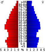
As of the 2010 census,[12] there were 33,361 people, 15,241 households, and 4,239 families residing in the county. The population density was 55 people per square mile (21/km²). There were 13,999 housing units at an average density of 24 per square mile (9/km²). The racial makeup of the county was 89.45% White, 6.80% Black or African American, 0.45% Native American, 0.36% Asian, 0.06% Pacific Islander, 1.10% from other races, and 1.78% from two or more races. 2.65% of the population were Hispanic or Latino of any race.
There were 15,241 households out of which 28% had children under the age of 18 living with them, 58% were married couples living together, 11% had a female head of household with no husband present, and 27% were non-families. 25% of all households were made up of individuals and 12% had someone living alone who was 65 years of age or older. The average household size was 2.45 and the average family size was 2.93.
In the county, the population was spread out with 24% under the age of 18, 8% from 18 to 24, 28% from 25 to 44, 25% from 45 to 64, and 16% who were 65 years of age or older. The median age was 39 years. For every 100 females there were 93.9 males. For every 100 females age 18 and over, there were 90.8 males.
The median income for a household in the county was $33,434, and the median income for a family was $41,454. Males had a median income of $30,917 versus $21,722 for females. The per capita income for the county was $18,837. About 10% of families and 14% of the population were below the poverty line, including 17% of those under age 18 and 20% of those age 65 or over.
Government
| Year | Republican | Democratic | Third Parties |
|---|---|---|---|
| 2016 | 77.9% 10,398 | 19.1% 2,554 | 3.0% 396 |
| 2012 | 73.9% 9,803 | 24.8% 3,290 | 1.3% 175 |
| 2008 | 70.3% 9,231 | 28.1% 3,695 | 1.6% 204 |
| 2004 | 62.9% 7,829 | 36.5% 4,546 | 0.7% 82 |
| 2000 | 51.0% 5,435 | 47.5% 5,060 | 1.5% 164 |
| 1996 | 46.7% 4,551 | 44.7% 4,361 | 8.6% 835 |
| 1992 | 37.0% 3,814 | 49.2% 5,063 | 13.8% 1,425 |
| 1988 | 53.5% 4,288 | 45.8% 3,672 | 0.7% 57 |
| 1984 | 49.1% 3,982 | 50.6% 4,103 | 0.4% 29 |
| 1980 | 34.0% 2,856 | 64.1% 5,387 | 2.0% 166 |
| 1976 | 22.9% 1,724 | 76.2% 5,732 | 0.8% 62 |
| 1972 | 61.8% 3,266 | 35.4% 1,867 | 2.8% 148 |
| 1968 | 16.1% 1,167 | 25.6% 1,848 | 58.3% 4,214 |
| 1964 | 26.2% 1,728 | 73.8% 4,861 | |
| 1960 | 22.5% 1,428 | 76.7% 4,862 | 0.8% 48 |
| 1956 | 21.2% 1,207 | 77.9% 4,434 | 0.9% 51 |
| 1952 | 26.8% 1,654 | 73.0% 4,510 | 0.2% 13 |
| 1948 | 8.8% 361 | 72.6% 2,969 | 18.5% 758 |
| 1944 | 13.3% 573 | 86.5% 3,735 | 0.2% 8 |
| 1940 | 12.1% 521 | 87.6% 3,781 | 0.3% 13 |
| 1936 | 11.1% 430 | 88.8% 3,451 | 0.2% 7 |
| 1932 | 8.4% 288 | 90.3% 3,095 | 1.3% 46 |
| 1928 | 23.8% 743 | 76.0% 2,377 | 0.2% 7 |
| 1924 | 13.0% 357 | 85.9% 2,356 | 1.1% 31 |
| 1920 | 30.7% 1,091 | 69.2% 2,463 | 0.2% 6 |
| 1916 | 16.4% 552 | 83.1% 2,791 | 0.4% 14 |
| 1912 | 19.6% 672 | 77.3% 2,651 | 3.2% 108 |
The governing body of Lincoln County is the Lincoln County Commission, which is divided into eight districts and 24 commissioners, three from each district. The body is chaired by the County Mayor. The government center of Lincoln County is the Lincoln County Courthouse in Fayetteville.
Communities
Cities
- Ardmore (partial)
- Fayetteville (county seat)
Town
- Petersburg (partial)
Census-designated places
Unincorporated communities
- Belleville
- Blanche
- Booneville
- Boonshill
- Cash Point
- Coldwater
- Dellrose
- Elora
- Green Gable
- Howell
- Howell Hill
- Hughey
- Kelso
- Kirkland
- Liberty
- Lincoln
- Mimosa
- McBurg
- Molino
- Mulberry
- New Dellrose
- New Hope
- Prospect
- Skinem
- Taft
- Vanntown
- Yukon
See also
References
- 1 2 Jack Towry and June Towry, "Lincoln County," Tennessee Encyclopedia of History and Culture. Retrieved: 21 October 2013.
- 1 2 "State & County QuickFacts". United States Census Bureau. Archived from the original on July 14, 2011. Retrieved December 3, 2013.
- ↑ "Find a County". National Association of Counties. Retrieved 2011-06-07.
- ↑ Gannett, Henry (1905). The Origin of Certain Place Names in the United States. U.S. Government Printing Office. p. 187.
- ↑ "2010 Census Gazetteer Files". United States Census Bureau. August 22, 2012. Retrieved April 7, 2015.
- ↑ "Population and Housing Unit Estimates". Retrieved June 9, 2017.
- ↑ "U.S. Decennial Census". United States Census Bureau. Retrieved April 7, 2015.
- ↑ "Historical Census Browser". University of Virginia Library. Retrieved April 7, 2015.
- ↑ Forstall, Richard L., ed. (March 27, 1995). "Population of Counties by Decennial Census: 1900 to 1990". United States Census Bureau. Retrieved April 7, 2015.
- ↑ "Census 2000 PHC-T-4. Ranking Tables for Counties: 1990 and 2000" (PDF). United States Census Bureau. April 2, 2001. Retrieved April 7, 2015.
- ↑ Based on 2000 census data
- ↑ "American FactFinder". United States Census Bureau. Retrieved 2011-05-14.
- ↑ Leip, David. "Dave Leip's Atlas of U.S. Presidential Elections". uselectionatlas.org. Retrieved 2018-03-11.
External links
| Wikimedia Commons has media related to Lincoln County, Tennessee. |
- Official site
- Lincoln County, TNGenWeb - free genealogy resources for the county
- Lincoln County at Curlie (based on DMOZ)
Places adjacent to Lincoln County, Tennessee | ||||||||||
|---|---|---|---|---|---|---|---|---|---|---|
| ||||||||||
Municipalities and communities of Lincoln County, Tennessee, United States | ||
|---|---|---|
| Cities | ||
| Town | ||
| CDPs | ||
| Unincorporated communities | ||
| Footnotes | ‡This populated place also has portions in an adjacent county or counties | |
