Montgomery County, Tennessee
| Montgomery County, Tennessee | ||
|---|---|---|
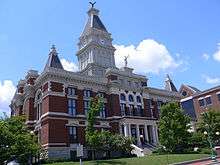 Montgomery County Courthouse in Clarksville | ||
| ||
|
Location in the U.S. state of Tennessee | ||
 Tennessee's location in the U.S. | ||
| Founded | 1796 | |
| Named for | John Montgomery[1] | |
| Seat | Clarksville | |
| Largest city | Clarksville | |
| Area | ||
| • Total | 544 sq mi (1,409 km2) | |
| • Land | 539 sq mi (1,396 km2) | |
| • Water | 4.7 sq mi (12 km2), 0.9% | |
| Population (est.) | ||
| • (2017) | 200,182 | |
| • Density | 371/sq mi (143/km2) | |
| Congressional district | 7th | |
| Time zone | Central: UTC−6/−5 | |
| Website |
mcgtn | |

Montgomery County is a county located in the U.S. state of Tennessee. As of the 2010 census, the population was 172,331.[2] The county seat is Clarksville.[3] The county was created in 1836.[1][4][5]
Montgomery County is included in the Clarksville, TN–KY Metropolitan Statistical Area.
History
The county was named for John Montgomery, a soldier in the American Revolutionary War and an early settler who founded the city of Clarksville. It was organized in 1796 when Tennessee County, North Carolina, was split, and Tennessee became a state. (The federal government had reached an agreement with certain of the original colonies, such as North Carolina, to give up their western claims across the Appalachians.) The same year, much of the eastern portion of the county was combined with land taken from Sumner County to form Robertson County, Tennessee. Later acts of the Tennessee General Assembly further reduced the county by 1871 to its current size and boundaries.[5]
Montgomery County was the site of several early saltpeter mines. Saltpeter is the main ingredient of gunpowder and was obtained by leaching the earth from several local caves. Bellamy Cave, located near Stringtown, still contains the remains of two dozen saltpeter leaching vats. It appeared to have a large operation. Cooper Creek Cave also shows evidence of extensive mining and contains the remains of "many saltpeter hoppers". Both were probably mined during the War of 1812. Dunbar Cave is reported to have been mined for saltpeter during the Mexican War of 1848, but commercial development has destroyed any evidence of this. Little mining is likely to have happened here during the Civil War, since the Union Army captured and occupied this part of Tennessee in early 1862.[6]
Geography
According to the U.S. Census Bureau, the county has a total area of 544 square miles (1,410 km2), of which 539 square miles (1,400 km2) is land and 4.7 square miles (12 km2) (0.9%) is water.[7]
Dunbar Cave
Montgomery County lies in a region of well-developed karst topography. A large cave system is named Dunbar Cave. Dunbar Cave is the centerpiece of Dunbar Cave State Park, which encompasses approximately 110 acres and is one of the most visited units in the Tennessee State Park System.
Dunbar Cave was extensively used by prehistoric Indians, who inhabited this area for thousands of years before European encounter. Remains of their cane torches have been found in the cave, and archaeologists have excavated numerous artifacts inside the entrance.[8] During a research trip into the cave on January 15, 2005, Park Ranger Amy Wallace, History professor Joe Douglas, local historian Billyfrank Morrison, and Geologist Larry E. Matthews, discovered Indian glyphs on the walls of the cave. Subsequent investigations by archaeologists from the University of Tennessee at Knoxville confirmed that these drawings were left by people of the Mississippian culture, which was active about 1000-1300 CE.[9][10] These Indian glyphs were featured for a few years on the tour of the cave.
In 2009 Tennessee closed Dunbar Cave to the public because White Nose Syndrome was diagnosed in a bat and they did not want the disease to spread. The above ground portion of the Park is still open to the public.
Adjacent counties
- Christian County, Kentucky (north)
- Todd County, Kentucky (northeast)
- Robertson County (east)
- Cheatham County (southeast)
- Dickson County (south)
- Houston County (southwest)
- Stewart County (west)
State protected areas
- Barnett's Woods State Natural Area
- Dunbar Cave State Natural Area
- Dunbar Cave State Park
- Haynes Bottom Wildlife Management Area
- Port Royal State Park (part)
- Shelton Ferry Wildlife Management Area
Demographics
| Historical population | |||
|---|---|---|---|
| Census | Pop. | %± | |
| 1800 | 2,899 | — | |
| 1810 | 8,021 | 176.7% | |
| 1820 | 12,219 | 52.3% | |
| 1830 | 14,349 | 17.4% | |
| 1840 | 16,927 | 18.0% | |
| 1850 | 21,045 | 24.3% | |
| 1860 | 20,895 | −0.7% | |
| 1870 | 24,747 | 18.4% | |
| 1880 | 28,481 | 15.1% | |
| 1890 | 29,697 | 4.3% | |
| 1900 | 36,017 | 21.3% | |
| 1910 | 33,672 | −6.5% | |
| 1920 | 32,265 | −4.2% | |
| 1930 | 30,882 | −4.3% | |
| 1940 | 33,346 | 8.0% | |
| 1950 | 44,186 | 32.5% | |
| 1960 | 55,645 | 25.9% | |
| 1970 | 62,721 | 12.7% | |
| 1980 | 83,342 | 32.9% | |
| 1990 | 100,498 | 20.6% | |
| 2000 | 134,768 | 34.1% | |
| 2010 | 172,331 | 27.9% | |
| Est. 2017 | 200,182 | [11] | 16.2% |
| U.S. Decennial Census[12] 1790-1960[13] 1900-1990[14] 1990-2000[15] 2010-2014[2] | |||
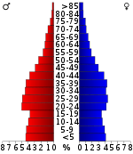
As of the census[17] of 2000, there were 134,768 people, 48,330 households, and 35,957 families residing in the county. The population density was 250 people per square mile (96/km²). There were 52,167 housing units at an average density of 97 per square mile (37/km²). The racial makeup of the county was 73.17% White, 19.18% Black or African American, 0.53% Native American, 1.82% Asian, 0.21% Pacific Islander, 2.18% from other races, and 2.91% from two or more races. 5.16% of the population were Hispanic or Latino of any race.
There were 48,330 households out of which 40.70% had children under the age of 18 living with them, 58.70% were married couples living together, 12.20% had a female householder with no husband present, and 25.60% were non-families. 20.20% of all households were made up of individuals and 5.50% had someone living alone who was 65 years of age or older. The average household size was 2.70 and the average family size was 3.11.
In the county, the population was spread out with 28.40% under the age of 18, 12.30% from 18 to 24, 34.30% from 25 to 44, 17.20% from 45 to 64, and 7.80% who were 65 years of age or older. The median age was 30 years. For every 100 females, there were 101.20 males. For every 100 females age 18 and over, there were 98.80 males.
The median income for a household in the county was $38,981, and the median income for a family was $43,023. Males had a median income of $30,696 versus $22,581 for females. The per capita income for the county was $17,265. About 7.90% of families and 10.00% of the population were below the poverty line, including 12.70% of those under age 18 and 10.70% of those age 65 or over.
Government
| Year | Republican | Democratic | Third Parties |
|---|---|---|---|
| 2016 | 56.1% 32,341 | 37.7% 21,699 | 6.2% 3,580 |
| 2012 | 54.3% 30,245 | 44.0% 24,499 | 1.8% 976 |
| 2008 | 53.3% 30,175 | 45.4% 25,716 | 1.3% 748 |
| 2004 | 58.4% 28,627 | 41.0% 20,070 | 0.6% 301 |
| 2000 | 50.3% 19,644 | 48.2% 18,818 | 1.5% 582 |
| 1996 | 45.0% 15,133 | 49.1% 16,498 | 5.9% 1,994 |
| 1992 | 41.5% 13,011 | 46.3% 14,507 | 12.2% 3,823 |
| 1988 | 57.7% 12,599 | 41.8% 9,145 | 0.5% 112 |
| 1984 | 56.6% 13,228 | 42.5% 9,939 | 0.9% 198 |
| 1980 | 41.1% 8,503 | 55.9% 11,573 | 3.0% 622 |
| 1976 | 32.1% 5,923 | 66.7% 12,310 | 1.2% 215 |
| 1972 | 56.4% 7,839 | 41.0% 5,691 | 2.7% 369 |
| 1968 | 22.5% 3,248 | 38.4% 5,538 | 39.1% 5,638 |
| 1964 | 21.7% 2,814 | 78.3% 10,178 | |
| 1960 | 24.8% 2,550 | 74.3% 7,635 | 0.8% 85 |
| 1956 | 25.4% 2,778 | 73.5% 8,034 | 1.1% 122 |
| 1952 | 30.8% 2,573 | 68.9% 5,759 | 0.3% 27 |
| 1948 | 14.3% 646 | 73.5% 3,310 | 12.2% 549 |
| 1944 | 19.1% 702 | 80.6% 2,971 | 0.4% 13 |
| 1940 | 20.5% 819 | 79.2% 3,158 | 0.3% 13 |
| 1936 | 20.1% 838 | 79.3% 3,314 | 0.7% 28 |
| 1932 | 22.5% 799 | 77.5% 2,747 | |
| 1928 | 48.3% 1,743 | 51.7% 1,866 | |
| 1924 | 32.0% 941 | 66.2% 1,946 | 1.8% 54 |
| 1920 | 40.6% 1,780 | 58.5% 2,564 | 0.9% 40 |
| 1916 | 32.8% 991 | 65.5% 1,976 | 1.7% 52 |
| 1912 | 21.1% 514 | 67.3% 1,638 | 11.6% 281 |
The County Commission has 21 members, each elected from a single-member district. In addition, voters elect a County Mayor at-large and certain other county-level positions, including the sheriff.
Elected officials
- County Mayor: Jim Durrett
- Assessor of Property: Erinne Hester
- Trustee: Kimberly Wiggins
- Sheriff: John Fuson
- Circuit Court Clerk: Cheryl J. Castle
- County Clerk: Kellie A. Jackson
- Register of Deeds: Connie Gunnett
- Highway Supervisor: Robert M. Frost
Communities
City
- Clarksville (county seat)
Unincorporated communities
- Cunningham
- Dotsonville
- Excell
- Fredonia
- Needmore
- New Providence
- Oak Plains
- Oakwood
- Oakridge
- Orgains Crossroads
- Palmyra
- Port Royal (partial)
- Sango
- Southside
- Shiloh
- Rossview
- St. Bethlehem
- Sailors Rest
- Tarsus
- Woodlawn
See also
References
- 1 2 Eleanor Williams, "Montgomery County," Tennessee Encyclopedia of History and Culture. Retrieved: March 11, 2013.
- 1 2 "State & County QuickFacts". United States Census Bureau. Archived from the original on July 15, 2011. Retrieved December 6, 2013.
- ↑ "Find a County". National Association of Counties. Retrieved June 7, 2011.
- ↑ "Tennessee: Individual County Chronologies". Tennessee Atlas of Historical County Boundaries. The Newberry Library. 2007. Retrieved April 18, 2015.
- 1 2 "Origins Of Tennessee County Names" (PDF). Tennessee Blue Book. 2005–2006. p. 512. Retrieved April 18, 2015.
- ↑ Larry E. Matthews, Dunbar Cave: The Showplace of the South, 2011, ISBN 978-1-879961-41-8
- ↑ "2010 Census Gazetteer Files". United States Census Bureau. August 22, 2012. Retrieved April 9, 2015.
- ↑ Larry E. Matthews, Dunbar Cave, 2005, ISBN 1-879961-22-9.
- ↑ Journal of Cave and Karst Studies, v. 74, no. 1, p. 19–32. DOI: 10.4311/
- ↑ Jan F. Simek, Joseph C. Douglas, and Amy Wallace, "Ancient Cave Art at Dunbar Cave State Natural Area", Tennessee Conservationist Magazine, September/October 2007, pp. 24 – 26.
- ↑ "Population and Housing Unit Estimates". Retrieved July 30, 2018.
- ↑ "U.S. Decennial Census". United States Census Bureau. Retrieved April 9, 2015.
- ↑ "Historical Census Browser". University of Virginia Library. Retrieved April 9, 2015.
- ↑ Forstall, Richard L., ed. (March 27, 1995). "Population of Counties by Decennial Census: 1900 to 1990". United States Census Bureau. Retrieved April 9, 2015.
- ↑ "Census 2000 PHC-T-4. Ranking Tables for Counties: 1990 and 2000" (PDF). United States Census Bureau. April 2, 2001. Retrieved April 9, 2015.
- ↑ Based on 2000 census data
- ↑ "American FactFinder". United States Census Bureau. Retrieved May 14, 2011.
- ↑ Leip, David. "Dave Leip's Atlas of U.S. Presidential Elections". uselectionatlas.org. Retrieved 2018-03-11.
External links
| Wikimedia Commons has media related to Montgomery County, Tennessee. |
- Official site
- Montgomery County, TNGenWeb - free genealogy resources for the county
- Montgomery County at Curlie (based on DMOZ)
Places adjacent to Montgomery County, Tennessee | ||||||||||
|---|---|---|---|---|---|---|---|---|---|---|
| ||||||||||
Municipalities and communities of Montgomery County, Tennessee, United States | ||
|---|---|---|
| City | ||
| Unincorporated communities | ||
| Military base | ||
| Ghost town | ||
