Obion County, Tennessee
| Obion County, Tennessee | |
|---|---|
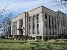 Obion County Courthouse | |
|
Location in the U.S. state of Tennessee | |
 Tennessee's location in the U.S. | |
| Founded | 1824[1] |
| Named for | Obion River[1] |
| Government • Mayor |
Benny McGuire |
| Seat | Union City |
| Largest city | Union City |
| Area | |
| • Total | 556 sq mi (1,440 km2) |
| • Land | 545 sq mi (1,412 km2) |
| • Water | 11 sq mi (28 km2), 1.9% |
| Population | |
| • (2010) | 31,807 |
| • Density | 58/sq mi (22/km2) |
| Congressional district | 8th |
| Time zone | Central: UTC−6/−5 |
| Website |
www |
Obion County is a county located in the northwest corner of the U.S. state of Tennessee. As of the 2010 census, the population was 31,807.[2] The county seat is Union City.[3] The county was formed in 1823 and organized in 1824.[1] It was named after the Obion River.[4]
Obion County is part of the Union City, TN–KY Micropolitan Statistical Area, which is also included in the Martin–Union City, TN–KY Combined Statistical Area.
History
In the year, 1811 there was a large seismic activity located on the New Madrid Fault Line. The series of earthquakes, while devastating, formed Reelfoot Lake.
Obion was later established in 1823 and organized the following year. It was named for the Obion River, which flows through the county and is a tributary of the nearby Mississippi River. The word "Obion" is believed to be derived from a Native American word meaning "many forks."[1]
The founding of Obion County originally came from the expansion of railroads. The county has since moved towards many agricultural and manufacturing productions. [5]
Geography
According to the U.S. Census Bureau, the county has a total area of 556 square miles (1,440 km2), of which 545 square miles (1,410 km2) is land and 11 square miles (28 km2) (1.9%) is water.[6] It is located in the "rolling hills of northwest Tennessee".[1]
Adjacent counties
- Fulton County, Kentucky (north)
- Hickman County, Kentucky (northeast)
- Weakley County (east)
- Gibson County (southeast)
- Dyer County (southwest)
- Lake County (west)
National protected area
State protected areas
- Glover Wetland Wildlife Management Area
- Gooch Wildlife Management Area
- Hop-In Refuge
- Obion River Wildlife Management Area (part)
- Reelfoot Lake State Natural Area (part)
- Reelfoot Lake State Park (part)
- Three Rivers Wildlife Management Area
Major highways
Demographics
| Historical population | |||
|---|---|---|---|
| Census | Pop. | %± | |
| 1830 | 2,099 | — | |
| 1840 | 4,814 | 129.3% | |
| 1850 | 7,633 | 58.6% | |
| 1860 | 12,817 | 67.9% | |
| 1870 | 15,584 | 21.6% | |
| 1880 | 22,912 | 47.0% | |
| 1890 | 27,273 | 19.0% | |
| 1900 | 28,286 | 3.7% | |
| 1910 | 29,946 | 5.9% | |
| 1920 | 28,393 | −5.2% | |
| 1930 | 29,086 | 2.4% | |
| 1940 | 30,978 | 6.5% | |
| 1950 | 29,056 | −6.2% | |
| 1960 | 26,957 | −7.2% | |
| 1970 | 29,936 | 11.1% | |
| 1980 | 32,781 | 9.5% | |
| 1990 | 31,717 | −3.2% | |
| 2000 | 32,450 | 2.3% | |
| 2010 | 31,807 | −2.0% | |
| Est. 2016 | 30,578 | [7] | −3.9% |
| U.S. Decennial Census[8] 1790-1960[9] 1900-1990[10] 1990-2000[11] 2010-2014[2] | |||
As of the census[13] of 2000, there were 32,450 people, 13,182 households, and 9,398 families residing in the county. The population density was 60 people per square mile (23/km²). There were 14,489 housing units at an average density of 27 per square mile (10/km²). The racial makeup of the county was 88.16% White, 9.85% Black or African American, 0.19% Asian, 0.14% Native American, 0.05% Pacific Islander, 0.91% from other races, and 0.71% from two or more races. 1.90% of the population were Hispanic or Latino of any race.
There were 13,182 households out of which 31.00% had children under the age of 18 living with them, 56.40% were married couples living together, 11.10% had a female householder with no husband present, and 28.70% were non-families. 25.70% of all households were made up of individuals and 12.10% had someone living alone who was 65 years of age or older. The average household size was 2.42 and the average family size was 2.89.
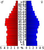
In the county, the population was spread out with 23.40% under the age of 18, 8.40% from 18 to 24, 27.70% from 25 to 44, 25.40% from 45 to 64, and 15.20% who were 65 years of age or older. The median age was 39 years. For every 100 females, there were 93.40 males. For every 100 females age 18 and over, there were 89.90 males.
The median income for a household in the county was $32,764, and the median income for a family was $40,533. Males had a median income of $32,963 versus $20,032 for females. The per capita income for the county was $17,409. About 10.10% of families and 13.30% of the population were below the poverty line, including 18.60% of those under age 18 and 15.10% of those age 65 or over.
Politics
| Year | Republican | Democratic | Third Parties |
|---|---|---|---|
| 2016 | 77.8% 9,526 | 19.8% 2,426 | 2.4% 297 |
| 2012 | 71.7% 8,814 | 27.0% 3,321 | 1.3% 162 |
| 2008 | 66.3% 8,873 | 32.2% 4,308 | 1.6% 211 |
| 2004 | 58.1% 7,859 | 41.0% 5,549 | 0.9% 127 |
| 2000 | 49.6% 6,168 | 48.7% 6,056 | 1.7% 216 |
| 1996 | 37.4% 4,310 | 54.0% 6,226 | 8.7% 1,000 |
| 1992 | 37.4% 4,812 | 50.5% 6,497 | 12.1% 1,555 |
| 1988 | 55.6% 6,037 | 44.1% 4,785 | 0.3% 36 |
| 1984 | 56.7% 6,384 | 42.4% 4,769 | 0.9% 99 |
| 1980 | 47.5% 5,397 | 50.7% 5,766 | 1.8% 202 |
| 1976 | 28.9% 2,986 | 69.8% 7,204 | 1.3% 130 |
| 1972 | 70.4% 5,800 | 27.2% 2,243 | 2.4% 200 |
| 1968 | 25.9% 2,420 | 23.9% 2,235 | 50.1% 4,680 |
| 1964 | 33.1% 2,802 | 66.9% 5,672 | |
| 1960 | 46.4% 3,800 | 51.8% 4,244 | 1.9% 152 |
| 1956 | 30.8% 2,349 | 67.9% 5,185 | 1.4% 103 |
| 1952 | 36.5% 2,682 | 62.9% 4,623 | 0.5% 40 |
| 1948 | 13.9% 642 | 75.6% 3,490 | 10.5% 485 |
| 1944 | 14.3% 615 | 85.4% 3,670 | 0.3% 13 |
| 1940 | 10.9% 536 | 88.7% 4,360 | 0.4% 18 |
| 1936 | 10.1% 417 | 89.9% 3,728 | |
| 1932 | 9.4% 334 | 89.2% 3,183 | 1.5% 52 |
| 1928 | 24.1% 789 | 76.0% 2,492 | |
| 1924 | 12.9% 485 | 85.5% 3,223 | 1.6% 61 |
| 1920 | 22.3% 1,307 | 77.4% 4,547 | 0.3% 20 |
| 1916 | 15.6% 591 | 83.6% 3,170 | 0.8% 29 |
| 1912 | 15.9% 455 | 75.2% 2,152 | 8.9% 256 |
The county is part of District 77 of the Tennessee House of Representatives, currently represented by Republican Bill Sanderson, and District 76, currently represented by Republican Andy Holt. The county is part of District 24 of the Tennessee Senate, currently represented by Republican John Stevens.[15] At the federal level, it is part of the state's 8th congressional district, currently represented by Republican David Kustoff.
Education
Obion County Schools
| School Name | Team Mascot | School Colors | School Website |
|---|---|---|---|
| Lake Road Elementary School | Generals | Blue/Orange | |
| Hillcrest Elementary School | Cougars | Red/Navy Blue | |
| Ridgemont Elementary School | Mustangs | Red/Yellow | |
| Black Oak Elementary School | Eagles | Yellow/Blue | |
| South Fulton Elementary School | Red Devils | Red/White | |
| South Fulton Middle/High School | Red Devils | Red/White | |
| Obion County Central High School | Rebels | Red/White/Blue |
Union City Schools
| School Name | Team Mascot | School Colors | School Website |
|---|---|---|---|
| Union City Elementary School | Tornadoes | Purple/Gold | 1 |
| Union City Middle School | Tornadoes | Purple/Gold | 1 |
| Union City High School | Tornadoes | Purple/Gold | 1 |
Attractions
Obion County is home to many attractions and activities.
- Discovery Park of America offers a world-class educational experience that focuses on nature, science, technology, history, and art. DPA serves as the main attraction in Obion County, and it is an interactive exhibit.
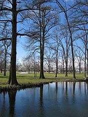
- Reelfoot Lake is a protected area in Obion County. It is an oasis for hiking, boating, and experiencing nature.
- Masquerade Theatre is a local theater groups and presents many high-quality productions. What started as the historical Captiol Theater has now been renovated to meet the community's needs. [16]
- The Obion County Fair is one of the biggest events held in the county. Fair Rides, Agricultural displays, pageants, and much more are held in late August every year. [17]
Media
- WENK-AM 1240 "The Greatest Hits of All Time"
- WWKF-FM 99.3 "Today's Best Music with Ace & TJ in the Morning"
- WQAK-FM 105.7 "The Quake" (alternative rock)
- The Union City Daily Messenger The County's Newspaper since 1926
Other services
Obion County has a public library, with a 30,000-square-foot (2,800 m2) building and a catalog of over 70,000 books, video and audio materials.[18]
Residents of the county's unincorporated communities have the option of paying $75 per year if they want firefighting services from the city of South Fulton.[19][20]
Communities
Cities
- South Fulton
- Union City (county seat)
- Woodland Mills
Towns
Unincorporated communities
See also
References
- 1 2 3 4 5 R.C. Forrester. "Obion County". Tennessee Encyclopedia of History and Culture. Retrieved 2010-10-10.
- 1 2 "State & County QuickFacts". United States Census Bureau. Archived from the original on July 15, 2011. Retrieved December 6, 2013.
- ↑ "Find a County". National Association of Counties. Archived from the original on May 31, 2011. Retrieved 2011-06-07.
- ↑ "Origins Of Tennessee County Names" (PDF). Tennessee Blue Book. 2005–2006. p. 512. Retrieved April 18, 2015.
- ↑ "Obion County | Tennessee Encyclopedia". Tennessee Encyclopedia. Retrieved 2018-08-16.
- ↑ "2010 Census Gazetteer Files". United States Census Bureau. August 22, 2012. Retrieved April 9, 2015.
- ↑ "Population and Housing Unit Estimates". Retrieved June 9, 2017.
- ↑ "U.S. Decennial Census". United States Census Bureau. Archived from the original on May 12, 2015. Retrieved April 9, 2015.
- ↑ "Historical Census Browser". University of Virginia Library. Retrieved April 9, 2015.
- ↑ Forstall, Richard L., ed. (March 27, 1995). "Population of Counties by Decennial Census: 1900 to 1990". United States Census Bureau. Retrieved April 9, 2015.
- ↑ "Census 2000 PHC-T-4. Ranking Tables for Counties: 1990 and 2000" (PDF). United States Census Bureau. April 2, 2001. Retrieved April 9, 2015.
- ↑ Based on 2000 census data.
- ↑ "American FactFinder". United States Census Bureau. Archived from the original on September 11, 2013. Retrieved 2011-05-14.
- ↑ Leip, David. "Dave Leip's Atlas of U.S. Presidential Elections". uselectionatlas.org. Retrieved 2018-03-12.
- ↑ Senate District 24 from the website of the Tennessee General Assembly
- ↑ "Obion County, Tennessee - Home". obioncounty.org. Retrieved 2018-08-16.
- ↑ "Obion County Fair – A Volunteer Tradition". www.obioncountyfair.net. Retrieved 2018-08-16.
- ↑ "About". Obion County Public Library. Retrieved 2010-10-10.
- ↑ "Firefighters watch as home burns to the ground". WPSD-TV. September 30, 2010. Archived from the original on October 3, 2010. Retrieved 2010-10-10.
- ↑ Jason Hibbs (December 5, 2011). "Home burns while firefighters watch, again". WPSD-TV. Archived from the original on December 8, 2011. Retrieved 2011-12-06.
External links
| Wikimedia Commons has media related to Obion County, Tennessee. |
- Obion County Joint Economic Development Council – joint initiative of the Obion County Chamber of Commerce and the Obion County Industrial Development Council
- Obion County, TNGenWeb - free genealogy resources for the county
- Obion County at Curlie (based on DMOZ)
- Obion County Schools
- Union City Schools
Places adjacent to Obion County, Tennessee | ||||||||||
|---|---|---|---|---|---|---|---|---|---|---|
| ||||||||||
Municipalities and communities of Obion County, Tennessee, United States | ||
|---|---|---|
| Cities | ||
| Towns | ||
| Unincorporated communities |
| |
| Footnotes | ‡This populated place also has portions in an adjacent county or counties | |
