Bradley County, Tennessee
| Bradley County, Tennessee | ||
|---|---|---|
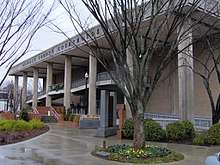 The Bradley County courthouse in Cleveland | ||
| ||
| Motto: "Agriculture and Industry"[1] | ||
|
Location in the U.S. state of Tennessee | ||
 Tennessee's location in the U.S. | ||
| Founded | May 2, 1836 | |
| Named for | Edward Bradley, state legislator[2] | |
| Seat | Cleveland | |
| Largest city | Cleveland | |
| Area | ||
| • Total | 331 sq mi (857 km2) | |
| • Land | 329 sq mi (852 km2) | |
| • Water | 2.7 sq mi (7 km2), 0.8% | |
| Population | ||
| • (2010) | 98,963 | |
| • Density | 301/sq mi (116/km2) | |
| ZIP Code(s) | 37310, 37311, 37312, 37320, 37323, 37353, 37364[3] | |
| Congressional districts | 3rd, 4th | |
| Time zone | Eastern: UTC−5/−4 | |
| Website |
www | |

Bradley County is a county located in the southeastern portion of the U.S. state of Tennessee. As of the 2010 census, the population was 98,963,[4] making it the thirteen most populous county in Tennessee. Its county seat is Cleveland.[5] It is named for Colonel Edward Bradley of Shelby County, Tennessee, who was colonel of Hale's Regiment in the American Revolution and the 15th Regiment of the Tennessee Volunteers in the War of 1812.[2]
Bradley County is included in the Cleveland, Tennessee Metropolitan Statistical Area, which is also included in the Chattanooga-Cleveland-Dalton, TN-GA-AL Combined Statistical Area.
History
Bradley County was likely first seen by Europeans on June 2, 1540 by Hernando De Soto and his expedition while traveling through the North American continent.[6] Bradley County was established on February 10, 1836. It was named to honor Colonel Edward Bradley who served in the War of 1812.[6] On January 20, 1838, Cleveland, a township with a population of 400, became the seat of Bradley County.[6] Red Clay State Park, the site of the last Cherokee council before the tribe's removal via Trail of Tears, is located in Bradley County.
Like most East Tennessee counties, Bradley County was largely opposed to secession on the eve of the Civil War. In Tennessee's Ordinance of Secession referendum on June 8, 1861, the county's residents voted against secession by a margin of 1,382 to 507.[7] The bridge over the Hiwassee River was burned on November 8, 1861, by members of the East Tennessee bridge-burning conspiracy led by Alfred Cate.[8]
Geography
According to the U.S. Census Bureau, the county has a total area of 331 square miles (860 km2), of which 329 square miles (850 km2) is land and 2.7 square miles (7.0 km2) (0.8%) is water.[9] The county is situated on a series of paralleling ridges running north-northeasterly which are part of the Ridge and Valley Appalachians. The highest of these, Candies Creek Ridge, runs through the center of Cleveland. Located in between these ridges are creeks, and there are several springs in the county, which made the area favorable to early settlers. Chatata is the Cherokee name for a region in the northeastern portion of the county where the so-called Chatata Wall was found in the late 19th century. The highest point in the county is located on the Hamilton County line along White Oak Mountain. The county is bordered on the north by the Hiwassee River.[10][11]
Adjacent counties
- Meigs County (northwest)
- McMinn County (north)
- Polk County (east)
- Murray County, Georgia (southeast)
- Whitfield County, Georgia (south)
- Hamilton County (west)
State protected areas
- Chickamauga Wildlife Management Area (part)
- Charlotte Anne Finnel Neal Wildlife Management Area
- Red Clay State Park
Demographics
| Historical population | |||
|---|---|---|---|
| Census | Pop. | %± | |
| 1840 | 7,385 | — | |
| 1850 | 12,259 | 66.0% | |
| 1860 | 11,701 | −4.6% | |
| 1870 | 11,652 | −0.4% | |
| 1880 | 12,124 | 4.1% | |
| 1890 | 13,607 | 12.2% | |
| 1900 | 15,759 | 15.8% | |
| 1910 | 16,336 | 3.7% | |
| 1920 | 18,652 | 14.2% | |
| 1930 | 22,870 | 22.6% | |
| 1940 | 28,498 | 24.6% | |
| 1950 | 32,338 | 13.5% | |
| 1960 | 38,324 | 18.5% | |
| 1970 | 50,686 | 32.3% | |
| 1980 | 67,547 | 33.3% | |
| 1990 | 73,712 | 9.1% | |
| 2000 | 87,965 | 19.3% | |
| 2010 | 98,963 | 12.5% | |
| Est. 2017 | 105,560 | [12] | 6.7% |
| U.S. Decennial Census[13] 1790-1960[14] 1900-1990[15] 1990-2000[16] 2010-2014[4] | |||

As of the census[18] of 2000, there were 87,965 people, 34,281 households, and 24,648 families residing in the county. The population density was 268 people per square mile (103/km²). There were 36,820 housing units at an average density of 112 per square mile (43/km²). The racial makeup of the county was 92.98% White, 3.99% Black or African American, 0.28% Native American, 0.57% Asian, 0.02% Pacific Islander, 0.89% from other races, and 1.27% from two or more races. 2.07% of the population were Hispanic or Latino of any race.
There were 34,281 households out of which 32.00% had children under the age of 18 living with them, 57.30% were married couples living together, 10.90% had a female householder with no husband present, and 28.10% were non-families. 23.40% of all households were made up of individuals and 8.20% had someone living alone who was 65 years of age or older. The average household size was 2.50 and the average family size was 2.94.
In the county, the population was spread out with 23.70% under the age of 18, 11.30% from 18 to 24, 29.80% from 25 to 44, 23.50% from 45 to 64, and 11.70% who were 65 years of age or older. The median age was 36 years. For every 100 females, there were 95.10 males. For every 100 females age 18 and over, there were 91.20 males.
The median income for a household in the county was $35,034, and the median income for a family was $41,779. Males had a median income of $30,654 versus $21,407 for females. The per capita income for the county was $18,108. About 9.00% of families and 12.20% of the population were below the poverty line, including 15.40% of those under age 18 and 11.60% of those age 65 or over.
Economy
With thirteen Fortune 500 manufacturers, Cleveland has the fifth largest industrial economy in Tennessee.[19] Cleveland is home to a variety of industries, including household cooking equipment, foodstuff, textiles, furniture, storage batteries, pharmaceuticals, industrial cleaning products, photographic processing, industrial and domestic chemicals, and automotive parts.[20] Major employers include Whirlpool, Johnston Coca-Cola, Mars, Incorporated, Procter & Gamble, Duracell, Hardwick Clothes, and Cleveland Chair Company.[20] Wacker Polysilicon, Olin Corporation, Amazon, and Arch Chemicals have factories and distribution centers in Charleston.[21] Resolute Forest Products, formerly Bowater, has a plant across the river from Charleston in Calhoun.[22]
Agriculture is also a major industry in Bradley County, with an annual market value of over $115 million. Bradley County is home to farms which raise beef cattle, poultry, dairy, and crops, such as corn, soybeans, and fruits and vegetables.[23]
Government
| Year | Republican | Democratic | Third Parties |
|---|---|---|---|
| 2016 | 77.0% 29,768 | 18.3% 7,070 | 4.7% 1,828 |
| 2012 | 76.0% 27,422 | 22.3% 8,037 | 1.8% 637 |
| 2008 | 74.2% 28,333 | 24.5% 9,357 | 1.3% 501 |
| 2004 | 72.8% 25,951 | 26.5% 9,431 | 0.7% 255 |
| 2000 | 68.5% 20,167 | 29.8% 8,768 | 1.7% 508 |
| 1996 | 58.1% 15,478 | 34.2% 9,095 | 7.7% 2,055 |
| 1992 | 55.7% 16,528 | 33.3% 9,889 | 11.1% 3,279 |
| 1988 | 71.9% 15,829 | 27.8% 6,122 | 0.4% 80 |
| 1984 | 72.5% 16,322 | 27.0% 6,085 | 0.4% 95 |
| 1980 | 59.6% 11,869 | 38.4% 7,638 | 2.0% 398 |
| 1976 | 50.6% 9,136 | 48.6% 8,776 | 0.8% 139 |
| 1972 | 77.3% 10,440 | 20.8% 2,804 | 2.0% 269 |
| 1968 | 50.0% 6,924 | 20.0% 2,762 | 30.0% 4,159 |
| 1964 | 54.1% 6,717 | 45.9% 5,693 | |
| 1960 | 69.7% 7,865 | 29.3% 3,307 | 1.0% 113 |
| 1956 | 65.0% 6,247 | 33.6% 3,225 | 1.5% 139 |
| 1952 | 63.4% 4,606 | 36.4% 2,646 | 0.2% 17 |
| 1948 | 57.1% 2,942 | 39.5% 2,036 | 3.4% 174 |
| 1944 | 66.2% 2,616 | 33.2% 1,312 | 0.6% 23 |
| 1940 | 56.7% 2,617 | 42.8% 1,976 | 0.5% 22 |
| 1936 | 47.6% 2,561 | 52.2% 2,806 | 0.2% 9 |
| 1932 | 54.1% 1,570 | 44.6% 1,295 | 1.3% 37 |
| 1928 | 75.7% 2,854 | 24.2% 913 | 0.1% 3 |
| 1924 | 63.1% 1,779 | 35.5% 999 | 1.4% 40 |
| 1920 | 67.3% 2,255 | 31.6% 1,058 | 1.1% 36 |
| 1916 | 64.7% 1,482 | 34.2% 784 | 1.1% 24 |
| 1912 | 28.7% 485 | 38.2% 645 | 33.1% 558 |
Bradley County has a 14-member county commission form of government, with two commissioners from each of seven districts.[25] The commission is headed by a chairman, who is chosen by fellow commissioners. The current chairman is Louie Alford from District 2.[25] Each district is also assigned a constable, also elected.[26] The county executive (or "county mayor"), separately elected, is Republican D. Gary Davis.[27] Elections take place every even year, with primaries in the first week of May and general elections in the first week of August, alomg with the state primary.
| District[25] | Seat A[25] | Seat B[25] |
|---|---|---|
| District 1 | Dennis Epperson | Mike Hughes |
| District 2 | Louie Alford | Thomas Crye |
| District 3 | Milan Blake | Johnny Mull |
| District 4 | Charlotte Peak | Howard Thompson |
| District 5 | Bobby Goins | Jeff Yarber |
| District 6 | Tim Mason | Erica Davis |
| District 7 | Kevin Raper | Bill Winters |
Bradley County is located in the 4th congressional district of Tennessee for the U.S. House of Representatives, represented by Republican Scott DesJarlais,[28] and the 3rd congressional district, represented by Republican Chuck Fleischmann.[29] For the Tennessee House of Representatives, Bradley County is part of both District 22, represented by Republican Dan Howell,[30] and District 24, represented by Republican Kevin Brooks.[31] Bradley County is part of district 9 for the Tennessee Senate, represented by Republican Mike Bell,[32] and District 10, represented by Republican Todd Gardenhire.[33]
Cleveland and Bradley County have always been majority-Republican, as has most of East Tennessee, even when Tennessee was part of the Solid South. Since the Republican Party's founding, only two Democratic Presidential Candidates have won Bradley County; Woodrow Wilson in 1912 and Franklin Delano Roosevelt in 1932.[34]
Infrastructure
Public safety
The Bradley County Sheriff's Office (BCSO) is the primary law enforcement agency for residents living outside the city limits of Cleveland and Charleston. The current sheriff is Steve Lawson, who has held that post since September 2018. The current chief deputy is Mark Smith.[35] Bradley County Fire-Rescue (BCFR) is the primary fire department for residents living outside of Cleveland and Charleston and outlying areas. It consists of ten stations and more than 120 employees and volunteers. The current chief is Troy Maney.[36]
Transportation
Air
Hardwick Field, also known as Cleveland Municipal Airport, was the county's principal airport from 1955 to 2013.[37][38] Cleveland Regional Jetport, located approximately two miles east of Hardwick Field opened on January 25, 2013, replacing Hardwick Field.[39] It consists of a 6,200-by-100-foot (1,890 by 30 m) runway.[39]
Rail
The county is served by the Norfolk Southern Railway, which forks in Cleveland and provides logistics for industries.[40]
Highways
Interstate 75 traverses the county from the southwest to the north, passing through the western edge of Cleveland. There are four exits on I-75 in Bradley County: three in Cleveland and one in Charleston. U.S. Route 11 and U.S. Route 64 intersect in downtown Cleveland. U.S. 11 connects to Chattanooga to the southwest and Athens to the north. U.S. 64 connects to Murphy, North Carolina to the east. S.R. 60 connects Cleveland to Dayton to the northwest and Dalton, Georgia to the south. APD-40, made up of the U.S. 64 Bypass and a section of S.R. 60 forms a beltway and bypass route around the business district of Cleveland. The U.S. 11 Bypass bypasses downtown Cleveland to the west.[40]
Principal highways

Secondary highways
Other major roadways
- Benton Pike
- Blue Springs Road
- Spring Place Road
- Freewill Road
- Dry Valley Road/Michigan Avenue Road
- Mouse Creek Road
- Walker Valley Road
- Old Lower River Road
- Upper River Road
- Chatata Valley Road
- Keith Valley Road
- Bancroft Road
- Old Chattanooga Pike/Old Alabama Road
Healthcare
The county's two main hospitals are Bradley Memorial Hospital and Cleveland Community Hospital. Prior to 2008, the two hospitals operated independently, when they were both purchased by SkyRidge Medical Center.[41] In 2015, the two hospitals were purchased by Tennova Healthcare.[42] Bradley Healthcare & Rehabilitation Center is a nursing home that serves the county. Bradley County Emergency Medical Services is an emergency medical service (EMS) agency of the county government that was established in 1972 and consists of three stations, eleven ambulances, and six ancillary vehicles, along with more than 60 full-time employees and more than 25 part-time employees.[43]
Education
Cleveland State Community College and Lee University are located in Bradley County. Public schools in the county are managed by the Bradley County Schools school district or the Cleveland City Schools school district. The county district has four public high schools: Bradley Central High School, Walker Valley High School, GOAL Academy, and REACH Adult High school. Cleveland High School is operated by the city school district. There is one State-accredited private Christian college preparatory school: Tennessee Christian Preparatory School.
Public schools
Bradley County Schools
High schools
- Bradley Central High School
- Walker Valley High School
- GOAL Academy
- REACH Adult High School
Middle schools
- Lake Forest Middle School
- Ocoee Middle School
Cleveland City Schools
High schools
- Cleveland High School
- Teen Learning Center
Middle school
- Cleveland Middle School
Private schools
- Tennessee Christian Preparatory School
- Cleveland Christian School
- Bowman Hills Adventist School
- Shenandoah Baptist Academy
- United Christian Academy
- Vanguard Christian Academy
- La Petite Academy
- Bachman Academy
Higher education
Media
Newspapers
The Cleveland Daily Banner is the county's primary newspaper. The paper was first published in 1854, making it one of the oldest in the state.[44] Additionally, the Chattanooga Times Free Press, a paper based in Chattanooga, also serves as a primary source of news for Bradley County residents.
Radio
Several radio stations located within Chattanooga and neighboring cities serve Bradley County, along with others licensed to Cleveland, which are listed below:[45]
| Call sign | Frequency | Format |
|---|---|---|
| W207C1 (WAYW) | 89.3 FM | Contemporary Christian |
| WSAA | 93.1 FM | Air 1, Contemporary Christian |
| WOOP-LP | 99.9 FM | Country |
| WUSY | 100.7 FM | Country |
| W267BI | 101.3 FM | Talk |
| WCLE-FM | 104.1 FM | Adult contemporary |
| W290CA (WTSE) | 105.9 FM | Contemporary Christian |
| WBAC | 1340 AM | News/Talk |
| WCLE-AM | 1570 AM | Talk |
Television
Bradley County is served by several TV stations licensed both in the county and in neighboring counties. Stations licensed in Cleveland include:
| Call sign[46] | Channel | Network |
|---|---|---|
| WPDP-LP | 25 | Fox, My Network TV |
| WTNB-CD | 27.1 | Heartland |
| WFLI-TV | 42, 53 | The CW, Me-TV |
Communities

Cities
- Cleveland (county seat)
- Charleston
Census-designated places
Unincorporated communities
See also
References
- ↑ Seal of Bradley County, Tennessee
- 1 2 John C. Bowman, "Bradley County," Tennessee Encyclopedia of History and Culture. Retrieved: 31 March 2013.
- ↑ Bradley County, Tennessee. Zipcodes.com
- 1 2 "State & County QuickFacts". United States Census Bureau. Retrieved November 29, 2013.
- ↑ "Find a County". National Association of Counties. Archived from the original on 2011-05-31. Retrieved 2011-06-07.
- 1 2 3 G., Lillard, Roy (1980). Bradley County. Dunn, Joy Bailey., Crawford, Charles Wann, 1931-. Memphis, Tenn.: Memphis State University Press. ISBN 0878700994. OCLC 6934932.
- ↑ Temple, Oliver Perry (1899). East Tennessee and the Civil War. R. Clarke Company. p. 199.
- ↑ Temple, East Tennessee and the Civil War, pp. 370-406.
- ↑ "2010 Census Gazetteer Files". United States Census Bureau. August 22, 2012. Retrieved April 1, 2015.
- ↑ US Geological Survey (1965). Charleston, Tenn (Map). Washington, D.C.: U.S. Department of the Interior. Retrieved November 11, 2017.
- ↑ East Cleveland, Tennessee (Map). US Geological Survey. 1976. Retrieved November 12, 2017.
- ↑ "Population and Housing Unit Estimates". Retrieved June 9, 2017.
- ↑ "U.S. Decennial Census". United States Census Bureau. Archived from the original on May 12, 2015. Retrieved April 1, 2015.
- ↑ "Historical Census Browser". University of Virginia Library. Retrieved April 1, 2015.
- ↑ Forstall, Richard L., ed. (March 27, 1995). "Population of Counties by Decennial Census: 1900 to 1990". United States Census Bureau. Retrieved April 1, 2015.
- ↑ "Census 2000 PHC-T-4. Ranking Tables for Counties: 1990 and 2000" (PDF). United States Census Bureau. April 2, 2001. Retrieved April 1, 2015.
- ↑ Based on 2000 census data
- ↑ "American FactFinder". United States Census Bureau. Archived from the original on 2013-09-11. Retrieved 2011-05-14.
- ↑ "Welcome to Cleveland, Tennessee!". clevelandtn.gov. 2 November 2012. Archived from the original on 5 August 2013. Retrieved 6 July 2013.
- 1 2 "Archived copy". Archived from the original on 2006-03-23. Retrieved 2005-12-29. Cleveland Chamber of Commerce
- ↑ Pare, Mike (2017-06-02). "Wacker starts work on $150 million plant expansion in Bradley County". Chattanooga Times-Free Press. Retrieved 26 October 2017.
- ↑ Flessner, Dave (March 13, 2013). "Paper mill in Calhoun, Tenn., once known as Bowater, idles its last newsprint machine". Chattanooga Times Free Press. Retrieved November 11, 2017.
- ↑ "County Profile: Bradley County, Tennessee" (PDF). agcensus.usda.gov. U.S. Department of Agriculture. 2012. Retrieved 2018-06-18.
- ↑ Leip, David. "Dave Leip's Atlas of U.S. Presidential Elections". uselectionatlas.org. Retrieved 2018-03-10.
- 1 2 3 4 5 County Commission - County Commissioners bradleycountytn.gov
- ↑ Constables by District bradleycountytn.gov
- ↑ County Mayor, Gary Davis bradleycountytn.gov
- ↑ "Congressman Scott DesJarlais". United States House of Representatives. Retrieved November 19, 2017.
- ↑ "Congressman Chuck Fleischmann". United States House of Representatives. Retrieved November 19, 2017.
- ↑ Tennessee General Assembly (2017). State House District 22 (PDF) (Map). Nashville: Tennessee General Assembly. Retrieved November 19, 2017.
- ↑ Tennessee General Assembly (2017). State House District 24 (PDF) (Map). Nashville: Tennessee General Assembly. Retrieved July 7, 2014.
- ↑ Tennessee General Assembly (2017). State Senate District 9 (PDF) (Map). Nashville: Tennessee General Assembly. Retrieved November 19, 2017.
- ↑ Tennessee General Assembly (2017). State Senate District 10 (PDF) (Map). Nashville: Tennessee General Assembly. Retrieved November 19, 2017.
- ↑ Lilliard, Roy G. (1980). Bradley County. Memphis State University Press. p. 24. ISBN 0-87870-099-4.
- ↑ Chief Deputy Brian Smith - Bradleysheriff.com
- ↑ Bradley County Fire-Rescue Bradleyco.net
- ↑ Love, Joyanna (December 29, 2013). "Cleveland's Hardwick Field officially closes Tuesday closes Tuesday". Clevelandbanner.com. Cleveland Daily Banner. Archived from the original on 17 March 2014. Retrieved 16 March 2014.
- ↑ Leach, Paul (December 27, 2013). "Cleveland's oldest airport, Hardwick Field, to close at year's end". Timesfreepress.com. Chattanooga Times Free Press. Retrieved 16 March 2014.
- 1 2 Official Transportation Map (back) (PDF) (Map). TDOT. 2016. Retrieved November 1, 2017.
- ↑ "Community forms Sky Ridge Medical Center". Medical News. Medical News. 2008. Archived from the original on 7 April 2014. Retrieved 6 April 2014.
- ↑ Report, Staff (September 30, 2015). "SkyRidge hospital renamed Tennova Healthcare-Cleveland". Chattanooga Times Free Press. Retrieved November 11, 2017.
- ↑ "Bradley County EMS". Bradleyco.net. Bradley County, TN. 2014.
- ↑ "Cleveland Daily Banner - Bradley County News Online Magazine". Archived from the original on 2007-10-10. Retrieved 2007-12-15.
- ↑ "Radio Stations in Cleveland, Tennessee". radiolocator.com. Radio Locator. Retrieved 15 December 2013.
- ↑ Pro Content and Design. "Television station listings in Cleveland, Tennessee". tvstations.procontentanddesign.com. Pro Content and Design. Archived from the original on 1 December 2008. Retrieved 28 December 2013.
External links
| Wikimedia Commons has media related to Bradley County, Tennessee. |
- Official site
- Cleveland-Bradley Chamber of Commerce
- Bradley County on FamilySearch Wiki – genealogical resources
- TNGenweb
- Bradley County at Curlie (based on DMOZ)
Places adjacent to Bradley County, Tennessee | ||||||||||
|---|---|---|---|---|---|---|---|---|---|---|
| ||||||||||
Municipalities and communities of Bradley County, Tennessee, United States | ||
|---|---|---|
| Cities | ||
| CDPs | ||
| Unincorporated communities | ||
| Footnotes | ‡This populated place also has portions in an adjacent county or counties | |
