Elora, Tennessee
| Elora, Tennessee | |
|---|---|
 | |
 | |
| Coordinates: 35°00′52″N 86°21′32″W / 35.01444°N 86.35889°WCoordinates: 35°00′52″N 86°21′32″W / 35.01444°N 86.35889°W | |
| Country | United States |
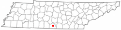
| State | Tennessee |
| County | Lincoln |
| Elevation | 928 ft (283 m) |
| Time zone | UTC-6 (Central (CST)) |
| • Summer (DST) | UTC-5 (CDT) |
| ZIP code | 37328 |
| Area code(s) | 931 |
| GNIS feature ID | 1283729[1] |
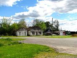
Elora is an unincorporated community in Lincoln County, Tennessee, United States. It lies approximately 16 miles (26 km) southeast of Fayetteville and 2 miles (3.2 km) north of the Alabama state line. It has a post office with zip code 37328.[2]
Elora is concentrated around the intersection of Tennessee State Route 121 and Tennessee State Route 122 (John Hunter Highway). SR 121 connects Elora to U.S. Route 64 and the Tims Ford Lake area to the north and Madison County, Alabama, to the southwest, while SR 122 connects Elora with Huntland to the east.
Elora was originally known as Baxter Station, and was established as a stop along the Fayetteville and Decherd Branch Railroad in the 1850s.[3]
Notable people
- George C. Hawkins, member of both houses of the Alabama State Legislature, 1951-1959 (House) and 1963-1967 (Senate), born in Elora in 1918; practicing attorney in Gadsden[4]
- Bill Hefner, member of the United States House of Representatives from North Carolina, was born in Elora.
References
- ↑ "Elora". Geographic Names Information System. United States Geological Survey.
- ↑ United States Postal Service (2012). "USPS - Look Up a ZIP Code". Retrieved 2016-04-22.
- ↑ Lincoln County, Tennessee: History Revealed Through Biographical and Genealogical Sketches of Its Ancestors (Lulu Press, 2012).
- ↑ "Hawkins, George Copeland, Jr". The Political Graveyard. Retrieved April 30, 2014.
External links

Municipalities and communities of Lincoln County, Tennessee, United States | ||
|---|---|---|
| Cities | ||
| Town | ||
| CDPs | ||
| Unincorporated communities | ||
| Footnotes | ‡This populated place also has portions in an adjacent county or counties | |
This article is issued from
Wikipedia.
The text is licensed under Creative Commons - Attribution - Sharealike.
Additional terms may apply for the media files.