Grainger County, Tennessee
| Grainger County, Tennessee | |
|---|---|
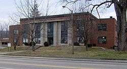 Grainger County Courthouse in Rutledge | |
|
Location in the U.S. state of Tennessee | |
 Tennessee's location in the U.S. | |
| Founded | 1796 |
| Named for | Mary Grainger Blount |
| Seat | Rutledge |
| Largest city | Bean Station |
| Area | |
| • Total | 302 sq mi (782 km2) |
| • Land | 281 sq mi (728 km2) |
| • Water | 22 sq mi (57 km2), 7.2% |
| Population | |
| • (2010) | 22,657 |
| • Density | 81/sq mi (31/km2) |
| Congressional district | 2nd |
| Time zone | Eastern: UTC−5/−4 |
| Website |
graingertn |
Grainger County is a county located in the U.S. state of Tennessee. As of the 2010 census, the population was 22,657.[1] Its county seat is Rutledge.[2] It is renowned for its tomatoes.
Grainger County is included in the Knoxville, TN Metropolitan Statistical Area.[3]
History
Grainger County was formed from Knox and Hawkins Counties in 1796, the year Tennessee became a state.[4] It is named for Mary Grainger Blount,[5] wife of William Blount. Anderson, Claiborne, Campbell, Hamblen, Hancock, Scott and Union Counties were formed from parts of the original Grainger County.[6]
Like many East Tennessee counties, Grainger County was generally opposed to secession from the Union. In Tennessee's Ordinance of Secession referendum on June 8, 1861, Grainger County voters rejected secession by 1,756 to 495.[7]
Annually since 1992, Grainger County hosts a festival for the county’s iconic tomatoes, featuring special events about the county’s history and its agricultural impact on the state. The festival takes place during the final full weekend in July.[8]
Geography
According to the U.S. Census Bureau, the county has a total area of 302 square miles (780 km2), of which 281 square miles (730 km2) is land and 22 square miles (57 km2) (7.2%) is water.[9] Grainger County is bounded on the northwest by the Clinch River (impounded by Norris Dam to form Norris Lake) and on the southeast by the Holston River (including Cherokee Lake). Clinch Mountain is a major geographic feature that effectively separates the county into a southern section (including Rutledge) and a northern section (including Washburn).
Indian Cave
Indian Cave is a historic site located on the Holston River near present-day Blaine. The cave was used for centuries before Europeans entered the area, as indigenous peoples settled in the area about 1000 CE.[10] Remains of cane torches and other artifacts located in the cave indicate use by prehistoric indigenous peoples.[11] The Iroquoian-speaking Cherokee migrated into the area from the northeast, making the eastern Ohio River valley and Appalachians down into South Carolina their historic territory.[10]
In the 1700s, a Cherokee village was located just west of the main cave entrance, before the people were pushed out by encroaching Anglo-American settlers.[12] The Donelson Party passed the Indian Cave entrance on their way down the Holston River in 1779 to settle present-day Nashville, Tennessee.[12] In the years after the American Revolutionary War, the number of settlers continued to increase. Under the Indian Removal Act of 1830, Congress authorized the president to remove the Indians from the Southeast to territory west of the Mississippi River.[10]
Robert Hoke, a former Confederate general from North Carolina, purchased the cave on July 21, 1869 as one of his business enterprises after the American Civil War. He had it mined for bat guano, a valuable natural fertilizer.[12]
Area businessmen formed the Indian Cave Park Association on January 4, 1916 to develop the cave as a commercial attraction, as was being done for other caves throughout the Great Smoky Mountains. The Association did not open the cave officially to the public until May 30, 1924. The cave is not open to visitors and is closed to the public as of 2005.[12]
Adjacent counties
- Hancock County (northeast)
- Hawkins County (northeast)
- Hamblen County (east)
- Jefferson County (south)
- Knox County (southwest)
- Union County (west)
- Claiborne County (northwest)
State protected areas
- Buffalo Springs Wildlife Management Area
Demographics
| Historical population | |||
|---|---|---|---|
| Census | Pop. | %± | |
| 1800 | 7,367 | — | |
| 1810 | 6,397 | −13.2% | |
| 1820 | 7,651 | 19.6% | |
| 1830 | 10,066 | 31.6% | |
| 1840 | 10,572 | 5.0% | |
| 1850 | 12,370 | 17.0% | |
| 1860 | 10,962 | −11.4% | |
| 1870 | 12,421 | 13.3% | |
| 1880 | 12,384 | −0.3% | |
| 1890 | 13,196 | 6.6% | |
| 1900 | 15,512 | 17.6% | |
| 1910 | 13,888 | −10.5% | |
| 1920 | 13,369 | −3.7% | |
| 1930 | 12,737 | −4.7% | |
| 1940 | 14,356 | 12.7% | |
| 1950 | 13,086 | −8.8% | |
| 1960 | 12,506 | −4.4% | |
| 1970 | 13,948 | 11.5% | |
| 1980 | 16,751 | 20.1% | |
| 1990 | 17,095 | 2.1% | |
| 2000 | 20,659 | 20.8% | |
| 2010 | 22,657 | 9.7% | |
| Est. 2016 | 23,072 | [13] | 1.8% |
| U.S. Decennial Census[14] 1790-1960[15] 1900-1990[16] 1990-2000[17] 2010-2014[1] | |||
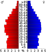
As of the census[19] of 2000, there were 20,659 people, 8,270 households, and 6,161 families residing in the county. The population density was 74 people per square mile (28/km²). There were 9,732 housing units at an average density of 35 per square mile (13/km²). The racial makeup of the county was 98.41% White, 0.32% Black or African American, 0.15% Native American, 0.09% Asian, 0.02% Pacific Islander, 0.40% from other races, and 0.61% from two or more races. 1.09% of the population were Hispanic or Latino of any race.
There were 8,270 households out of which 31.40% had children under the age of 18 living with them, 61.90% were married couples living together, 8.80% had a female householder with no husband present, and 25.50% were non-families. 22.50% of all households were made up of individuals and 9.10% had someone living alone who was 65 years of age or older. The average household size was 2.48 and the average family size was 2.89.
In the county, the population was spread out with 22.90% under the age of 18, 8.20% from 18 to 24, 30.50% from 25 to 44, 25.80% from 45 to 64, and 12.50% who were 65 years of age or older. The median age was 38 years. For every 100 females, there were 99.00 males. For every 100 females age 18 and over, there were 96.50 males.
The median income for a household in the county was $27,997, and the median income for a family was $33,347. Males had a median income of $25,781 versus $19,410 for females. The per capita income for the county was $14,505. About 15.10% of families and 18.70% of the population were below the poverty line, including 22.40% of those under age 18 and 26.00% of those age 65 or over.
Communities
City
Towns
Unincorporated communities
Politics
| Year | Republican | Democratic | Third Parties |
|---|---|---|---|
| 2016 | 82.7% 6,626 | 14.4% 1,154 | 2.9% 228 |
| 2012 | 75.4% 5,470 | 23.0% 1,668 | 1.6% 114 |
| 2008 | 70.6% 5,297 | 27.5% 2,066 | 1.9% 140 |
| 2004 | 65.2% 4,907 | 34.1% 2,569 | 0.7% 51 |
| 2000 | 60.5% 3,746 | 38.1% 2,361 | 1.4% 87 |
| 1996 | 52.7% 2,875 | 39.7% 2,162 | 7.6% 416 |
| 1992 | 49.9% 2,772 | 40.4% 2,242 | 9.7% 539 |
| 1988 | 65.5% 2,734 | 34.1% 1,423 | 0.4% 17 |
| 1984 | 66.7% 3,212 | 32.5% 1,565 | 0.8% 37 |
| 1980 | 67.1% 3,254 | 30.8% 1,495 | 2.0% 99 |
| 1976 | 57.7% 2,805 | 41.5% 2,018 | 0.8% 40 |
| 1972 | 76.5% 2,842 | 22.3% 828 | 1.2% 43 |
| 1968 | 67.3% 2,788 | 18.4% 761 | 14.4% 596 |
| 1964 | 66.8% 2,634 | 33.2% 1,309 | |
| 1960 | 75.9% 3,017 | 23.6% 939 | 0.5% 21 |
| 1956 | 72.4% 2,497 | 26.5% 913 | 1.1% 39 |
| 1952 | 76.3% 3,030 | 23.6% 937 | 0.1% 5 |
| 1948 | 71.8% 1,824 | 25.3% 644 | 2.9% 74 |
| 1944 | 76.0% 1,938 | 23.7% 605 | 0.3% 7 |
| 1940 | 66.0% 1,688 | 32.9% 842 | 1.1% 27 |
| 1936 | 60.2% 1,754 | 39.5% 1,153 | 0.3% 9 |
| 1932 | 56.3% 1,325 | 42.3% 995 | 1.4% 33 |
| 1928 | 75.3% 1,457 | 24.1% 466 | 0.6% 12 |
| 1924 | 68.8% 1,464 | 30.6% 651 | 0.6% 13 |
| 1920 | 70.7% 2,158 | 29.3% 895 | 0.0% 1 |
| 1916 | 64.4% 1,529 | 35.5% 843 | 0.1% 3 |
| 1912 | 29.9% 741 | 33.9% 841 | 36.3% 900 |
Grainger County is one of the counties in Tennessee’s 2nd congressional district which has voted for the Republican Party since before the Civil War.[21]
See also
References
- 1 2 "State & County QuickFacts". United States Census Bureau. Archived from the original on July 10, 2011. Retrieved November 30, 2013.
- ↑ "Find a County". National Association of Counties. Archived from the original on 2011-05-31. Retrieved 2011-06-07.
- ↑ "Revised Delineations of Metropolitan Statistical Areas, Micropolitan Statistical Areas, and Combined Statistical Areas, and Guidance on Uses of the Delineations of These Areas" (PDF). Office of Management and Budget. Retrieved April 27, 2014.
- ↑ Kevin Collins, "Grainger County," Tennessee Encyclopedia of History and Culture. Retrieved: 20 July 2013.
- ↑ Gannett, Henry (1905). The Origin of Certain Place Names in the United States. Govt. Print. Off. p. 141.
- ↑ "Grainger County Archives". www.graingerarchives.org. Retrieved 2018-03-10.
- ↑ Oliver Perry Temple, East Tennessee and the Civil War (R. Clarke Company, 1899), p. 199.
- ↑ "Grainger County Tomato Festival TN". Grainger County Tomato Festival TN. Retrieved 2017-11-15.
- ↑ "2010 Census Gazetteer Files". United States Census Bureau. August 22, 2012. Retrieved April 5, 2015.
- 1 2 3 "History of Great Smoky Mountain Park", Knoxville, Tennessee Information Gateway, accessed 26 May 2012
- ↑ Larry E. Matthews, Chapter 4: "Indian Cave", Caves of Knoxville and the Great Smoky Mountains, National Speleological Society, 2008, ISBN 978-1-879961-30-2, pp. 83-104
- 1 2 3 4 Matthews (2008), "Caves of Knoxville", pp. 83-104
- ↑ "Population and Housing Unit Estimates". Retrieved June 9, 2017.
- ↑ "U.S. Decennial Census". United States Census Bureau. Archived from the original on May 12, 2015. Retrieved April 5, 2015.
- ↑ "Historical Census Browser". University of Virginia Library. Retrieved April 5, 2015.
- ↑ Forstall, Richard L., ed. (March 27, 1995). "Population of Counties by Decennial Census: 1900 to 1990". United States Census Bureau. Retrieved April 5, 2015.
- ↑ "Census 2000 PHC-T-4. Ranking Tables for Counties: 1990 and 2000" (PDF). United States Census Bureau. April 2, 2001. Retrieved April 5, 2015.
- ↑ Based on 2000 census data
- ↑ "American FactFinder". United States Census Bureau. Archived from the original on 2013-09-11. Retrieved 2011-05-14.
- ↑ Leip, David. "Dave Leip's Atlas of U.S. Presidential Elections". uselectionatlas.org. Retrieved 2018-03-10.
- ↑ "Grainger County Election Commission". graingercoelectioncommission.com. Retrieved 2017-11-16.
External links
| Wikimedia Commons has media related to Grainger County, Tennessee. |
- Official website
- Grainger County Tomato Festival
- Grainger County, TNGenWeb - free genealogy resources for the county
- Grainger County at Curlie (based on DMOZ)
- Hear it spoken (Voice of Grainger County Mayor Mark Hipsher, 2010)
Places adjacent to Grainger County, Tennessee | ||||||||||
|---|---|---|---|---|---|---|---|---|---|---|
| ||||||||||
Municipalities and communities of Grainger County, Tennessee, United States | ||
|---|---|---|
| City | ||
| Towns | ||
| Unincorporated communities | ||
| Footnotes | ‡This populated place also has portions in an adjacent county or counties | |
| Principal City |   | |
|---|---|---|
| Other Cities | ||
| Counties | ||
