Maury County, Tennessee
| Maury County, Tennessee | ||
|---|---|---|
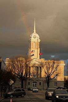 Maury County Courthouse in Columbia | ||
| ||
|
Location in the U.S. state of Tennessee | ||
 Tennessee's location in the U.S. | ||
| Founded | 1807 | |
| Named for | Abram Poindexter Maury[1] | |
| Seat | Columbia | |
| Largest city | Spring Hill | |
| Area | ||
| • Total | 616 sq mi (1,595 km2) | |
| • Land | 613 sq mi (1,588 km2) | |
| • Water | 2.4 sq mi (6 km2), 0.4% | |
| Population | ||
| • (2016) | 89,981 | |
| • Density | 147/sq mi (57/km2) | |
| Congressional districts | 4th, 7th | |
| Time zone | Central: UTC−6/−5 | |
| Website |
www | |
|
Footnotes: Estimate | ||

Maury County (/ˈmʌri/ MURR-ee) is a county located in the U.S. state of Tennessee, in the Middle Tennessee region. As of the 2010 census, the population was 80,956.[2] Its county seat is Columbia.[3]
Maury County is part of the Nashville-Davidson-Murfreesboro-Franklin, TN Metropolitan Statistical Area.
History
The county was formed in 1807 from Williamson County and Indian lands. Maury County was named in honor of Major Abram Poindexter Maury of Williamson County, who was a member of the Tennessee legislature, and an uncle of Commodore Matthew Fontaine Maury.[1]
The rich soil of Maury County led to a thriving agricultural sector, starting in the 19th century. The county was part of a 41-county region that became known and legally defined as Middle Tennessee. Planters in Maury County formerly relied on the labor of African-American slaves to raise and process cotton, tobacco, and livestock (especially dairy cattle). Racial violence was less than in some areas, but the county had 5 documented lynchings in the period from 1877 to 1950; three took place in the early 20th century.[4]
With the mechanization of agriculture, particularly from the 1930s, the need for farm labor in the county was reduced. Also, many African Americans moved to northern and midwestern industrial cities in the 20th century for the employment opportunities, particularly during the Great Migration. This movement out of the county continued after World War II. Other changes have led to increased population since the late 20th century, and the county has led the state in beef cattle production.[1]
Columbia Race Riot of 1946
On the night of February 26–27, 1946, a disturbance known as the "Columbia Race Riot" took place in Columbia, the county seat. It was the first time in Tennessee that black Americans had fought to defend themselves from a white attack. The national press called it the first "major racial confrontation" after the Second World War.[5] It marked a new spirit of resistance by African-American veterans and others following their participation in World War II, by which they believed they had earned their full rights as citizens, even in the Jim Crow South.[6] It began when James Stephenson, an African-American Navy veteran, was in a store with his mother, who complained when she learned that a radio she had left for repair had been sold. A white repair apprentice, Billy Fleming, struck her. Stephenson had been a welterweight on the Navy boxing team and sent Fleming through a glass window. Both Stephenson and his mother were arrested, and Fleming's father convinced the sheriff to charge them with attempted murder. When they learned that Fleming had gone to a hospital, a white mob gathered and it was feared the Stephensons would be lynched.[7]
Julius Blair, a 76-year-old store owner in the black community, arranged to have the Stephensons released to his custody. He drove them out of town for their protection. The mob did not disperse, but about one hundred black men patrolled their neighborhood south of the courthouse square, determined to resist. Four police officers were shot and wounded after entering "Mink Slide", the name whites gave the African-American business district, also known as "The Bottom". After this attack on the police, the city requested state troopers who were sent as reinforcements, soon outnumbering the black patrollers. The state troopers began ransacking businesses and rounding up African Americans. They cut off phone service to Mink Slide, but the owner of a funeral home managed to call Nashville and ask for help from the NAACP. The county jail was overcrowded with black "suspects", who were questioned for days without counsel. Two black men were killed and one wounded while "trying to escape."[8] Some 25 black men were eventually charged with rioting and attempted murder.
The NAACP sent Thurgood Marshall as the lead attorney to defend Stephenson and the other black men. He gained a change of venue to a nearby town, and trials took place throughout the summer of 1946. Marshall was assisted by two local attorneys, Zephaniah Alexander Looby, originally from the British West Indies, and Maurice Weaver, a white activist lawyer from Nashville. Marshall was also preparing litigation for education and voting rights cases. (In 1954 he gained a ruling by the United States Supreme Court in Brown v. Board of Education that segregation of public schools was unconstitutional. Marshall later was appointed as the first black United States Supreme Court justice.) Looby was later elected to the Nashville City Council.[9]
Marshall gained acquittals of 23 of the black defendants, even with an all-white jury.[5] At the last murder trials in November 1946, Marshall won acquittal for Rooster Bill Pillow, and a reduction in sentence for Papa Kennedy, allowing him to go free on bail.[10]
Geography
According to the U.S. Census Bureau, the county has a total area of 616 square miles (1,600 km2), of which 613 square miles (1,590 km2) is land and 2.4 square miles (6.2 km2) (0.4%) is water.[11]
Adjacent counties
- Williamson County (north)
- Marshall County (east)
- Giles County (south)
- Lawrence County (southwest)
- Lewis County (west)
- Hickman County (northwest)
National protected area
- Natchez Trace Parkway (part)
State protected areas
- Duck River Complex State Natural Area
- James K. Polk Home (state historic site)
- Stillhouse Hollow Falls State Natural Area
- Williamsport Wildlife Management Area
- Yanahli Wildlife Management Area
Demographics
| Historical population | |||
|---|---|---|---|
| Census | Pop. | %± | |
| 1810 | 10,359 | — | |
| 1820 | 22,141 | 113.7% | |
| 1830 | 27,665 | 24.9% | |
| 1840 | 28,186 | 1.9% | |
| 1850 | 29,520 | 4.7% | |
| 1860 | 32,498 | 10.1% | |
| 1870 | 36,289 | 11.7% | |
| 1880 | 39,904 | 10.0% | |
| 1890 | 38,112 | −4.5% | |
| 1900 | 42,703 | 12.0% | |
| 1910 | 40,456 | −5.3% | |
| 1920 | 35,403 | −12.5% | |
| 1930 | 34,016 | −3.9% | |
| 1940 | 40,357 | 18.6% | |
| 1950 | 40,368 | 0.0% | |
| 1960 | 41,699 | 3.3% | |
| 1970 | 43,376 | 4.0% | |
| 1980 | 51,095 | 17.8% | |
| 1990 | 54,812 | 7.3% | |
| 2000 | 69,498 | 26.8% | |
| 2010 | 80,956 | 16.5% | |
| Est. 2016 | 89,981 | [12] | 11.1% |
| U.S. Decennial Census[13] 1790-1960[14] 1900-1990[15] 1990-2000[16] 2010-2014[2] | |||
As of the census[18] of 2000, there were 69,498 people, 26,444 households, and 19,277 families residing in the county. The population density was 113 people per square mile (44/km²). There were 28,674 housing units at an average density of 47 per square mile (18/km²). The racial makeup of the county was 57% White, 41% Black or African American, 0.31% Native American, 0.33% Asian, 0.02% Pacific Islander, 1.44% from other races, and 1.25% from two or more races. 3.26% of the population were Hispanic or Latino of any race.
There were 26,444 households out of which 34.80% had children under the age of 18 living with them, 55.90% were married couples living together, 12.90% had a female householder with no husband present, and 27.10% were non-families. 23.20% of all households were made up of individuals and 8.80% had someone living alone who was 65 years of age or older. The average household size was 2.58 and the average family size was 3.03.
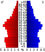
In the county, the population was spread out with 26.20% under the age of 18, 8.70% from 18 to 24, 29.80% from 25 to 44, 23.20% from 45 to 64, and 12.00% who were 65 years of age or older. The median age was 36 years. For every 100 females, there were 94.60 males. For every 100 females age 18 and over, there were 90.30 males.
The median income for a household in the county was $41,591, and the median income for a family was $48,010. Males had a median income of $37,675 versus $23,334 for females. The per capita income for the county was $19,365. About 8.30% of families and 10.90% of the population were below the poverty line, including 14.50% of those under age 18 and 12.10% of those age 65 or over.
There were declines in population and declines in population growth from 1900 to 1930, and from 1940 to 1970. These periods related to the migration of people from rural to urban areas for work, especially as mechanization reduced the need for agricultural laborers. In addition, these time periods related to the Great Migration of African Americans out of the Jim Crow South to northern and midwestern industrial cities for more opportunities. The African-American population became highly urbanized. Expansion of the railroads, auto and steel industries provided new work opportunities in the early 20th century.
Transportation
The Maury County Airport is a county-owned public-use airport located 2 nautical miles (3.7 km; 2.3 mi) northeast of the central business district of Mount Pleasant[19] and 8 nautical miles (15 km; 9.2 mi) southwest of Columbia.[20]
Communities
Cities
- Columbia (county seat)
- Mount Pleasant
- Spring Hill (partly in Williamson County)
Census-designated place
- Summertown (mostly in Lawrence County and a small portion in Lewis County)
Unincorporated communities
- Ashwood
- Carters Creek
- Culleoka
- Glendale
- Fly
- Fountain Heights
- Hampshire
- Hopewell
- Mt. Joy
- Neapolis
- Santa Fe
- Sawdust
- Williamsport
Notable people
- Cordie Cheek (1916–1933) – 19-year-old black youth lynched in 1933 by a mob including county officials, after being falsely accused of rape[21]
- James P. Eagle (1837–1904) – 16th Governor of Arkansas[22]
- Sam. R. Watkins (1839–1901) – author of Co. Aytch (1882)
Politics
| Year | Republican | Democratic | Third Parties |
|---|---|---|---|
| 2016 | 67.3% 23,799 | 28.4% 10,038 | 4.3% 1,532 |
| 2012 | 62.7% 20,708 | 35.8% 11,825 | 1.4% 473 |
| 2008 | 60.1% 20,288 | 38.7% 13,058 | 1.3% 421 |
| 2004 | 58.3% 17,505 | 41.2% 12,379 | 0.5% 159 |
| 2000 | 51.0% 11,930 | 47.6% 11,127 | 1.5% 343 |
| 1996 | 42.5% 8,737 | 50.4% 10,367 | 7.2% 1,470 |
| 1992 | 36.4% 7,440 | 48.9% 9,997 | 14.8% 3,022 |
| 1988 | 56.8% 8,397 | 42.5% 6,280 | 0.8% 111 |
| 1984 | 56.2% 9,008 | 43.4% 6,950 | 0.5% 75 |
| 1980 | 44.2% 6,637 | 52.9% 7,957 | 2.9% 436 |
| 1976 | 37.3% 5,327 | 61.3% 8,747 | 1.3% 191 |
| 1972 | 66.3% 7,371 | 29.3% 3,262 | 4.4% 488 |
| 1968 | 20.9% 3,048 | 23.3% 3,401 | 55.8% 8,148 |
| 1964 | 37.4% 4,605 | 62.6% 7,716 | |
| 1960 | 38.0% 4,133 | 60.8% 6,615 | 1.2% 131 |
| 1956 | 29.4% 2,853 | 68.6% 6,662 | 2.0% 191 |
| 1952 | 32.6% 3,582 | 67.1% 7,377 | 0.3% 36 |
| 1948 | 15.9% 895 | 51.6% 2,906 | 32.6% 1,834 |
| 1944 | 13.4% 747 | 86.3% 4,814 | 0.3% 18 |
| 1940 | 12.2% 634 | 87.3% 4,529 | 0.4% 23 |
| 1936 | 11.5% 497 | 88.1% 3,809 | 0.4% 19 |
| 1932 | 13.5% 535 | 85.8% 3,392 | 0.6% 25 |
| 1928 | 27.2% 1,362 | 72.8% 3,652 | |
| 1924 | 21.4% 844 | 76.1% 3,000 | 2.5% 100 |
| 1920 | 33.5% 1,379 | 65.5% 2,693 | 1.0% 41 |
| 1916 | 24.6% 720 | 74.1% 2,169 | 1.3% 37 |
| 1912 | 18.3% 615 | 68.7% 2,309 | 13.0% 437 |
See also
References
- 1 2 3 Marise P. Lightfoot, "Maury County," Tennessee Encyclopedia of History and Culture. Retrieved: 11 March 2013.
- 1 2 "State & County QuickFacts". United States Census Bureau. Archived from the original on July 14, 2011. Retrieved December 6, 2013.
- ↑ "Find a County". National Association of Counties. Retrieved 2011-06-07.
- ↑ Lynching in America, 2nd edition, Supplement by County, p. 6
- 1 2 King (2012), Devil in the Grove, p. 8
- ↑ Gilbert King, Devil in the Grove: Thurgood Marshall, the Groveland Boys, and the Dawn of a New America, HarperCollins, 2012, pp. 7-20
- ↑ King (2012), Devil in the Grove, p. 11
- ↑ King (2012), Devil in the Grove, p. 13
- ↑ Carroll Van West. "Columbia race riot, 1946". Tennessee Encyclopedia of History and Culture. Archived from the original on 2016-03-03. Retrieved 2008-07-04.
- ↑ King (2012), Devil in the Grove, p. 14
- ↑ "2010 Census Gazetteer Files". United States Census Bureau. August 22, 2012. Retrieved April 9, 2015.
- ↑ "Population and Housing Unit Estimates". Retrieved June 9, 2017.
- ↑ "U.S. Decennial Census". United States Census Bureau. Retrieved April 9, 2015.
- ↑ "Historical Census Browser". University of Virginia Library. Retrieved April 9, 2015.
- ↑ Forstall, Richard L., ed. (March 27, 1995). "Population of Counties by Decennial Census: 1900 to 1990". United States Census Bureau. Retrieved April 9, 2015.
- ↑ "Census 2000 PHC-T-4. Ranking Tables for Counties: 1990 and 2000" (PDF). United States Census Bureau. April 2, 2001. Retrieved April 9, 2015.
- ↑ Based on 2000 census data
- ↑ "American FactFinder". United States Census Bureau. Retrieved 2011-05-14.
- ↑ FAA Airport Master Record for MRC (Form 5010 PDF). Federal Aviation Administration. Effective August 25, 2011.
- ↑ "Distance and heading from Columbia, TN (35°36'54"N 87°02'40"W) to Maury County Airport (35°33'16"N 87°10'45"W)". Great Circle Mapper. Retrieved May 7, 2012.
- ↑ King, Gilbert (2012). Devil in the Grove: Thurgood Marshall, the Groveland Boys and the Dawn of a New America. p. 12.
- ↑ "Arkansas Governor James Philip Eagle". National Governors Association. Retrieved August 17, 2012.
- ↑ Leip, David. "Dave Leip's Atlas of U.S. Presidential Elections". uselectionatlas.org. Retrieved 2018-03-11.
External links
| Wikimedia Commons has media related to Maury County, Tennessee. |
- Official site
- Maury County, TNGenWeb - free genealogy resources for the county
- Maury County at Curlie (based on DMOZ)
- Columbia Daily Herald
Places adjacent to Maury County, Tennessee | ||||||||||
|---|---|---|---|---|---|---|---|---|---|---|
| ||||||||||
Municipalities and communities of Maury County, Tennessee, United States | ||
|---|---|---|
| Cities | ||
| CDPs | ||
| Unincorporated communities | ||
| Footnotes | ‡This populated place also has portions in an adjacent county or counties | |
| Principal City | ||
|---|---|---|
| Other Major Cities | ||
| Counties | ||
