Wayne County, Tennessee
| Wayne County, Tennessee | |
|---|---|
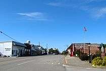
 Wayne County Courthouse in Waynesboro | |
|
Location in the U.S. state of Tennessee | |
 Tennessee's location in the U.S. | |
| Founded | 1817 |
| Named for | General Anthony Wayne[1] |
| Seat | Waynesboro |
| Largest city | Clifton |
| Area | |
| • Total | 736 sq mi (1,906 km2) |
| • Land | 734 sq mi (1,901 km2) |
| • Water | 1.6 sq mi (4 km2), 0.2% |
| Population | |
| • (2010) | 17,021 |
| • Density | 23/sq mi (9/km2) |
| Congressional district | 7th |
| Time zone | Central: UTC−6/−5 |
| Website |
www |
Wayne County is a county located in Tennessee. As of the 2010 census, the population was 17,021.[2] Its county seat is Waynesboro.[3] The county is named after General "Mad Anthony" Wayne.
History
Wayne County was created in 1817 from parts of Hickman and Humphreys counties. Waynesboro, its county seat, was established in 1821.[1] The city of Clifton emerged as a key river port in the mid-19th century.[1]
Geography
According to the U.S. Census Bureau, the county has a total area of 736 square miles (1,910 km2), of which 734 square miles (1,900 km2) is land and 1.6 square miles (4.1 km2) (0.2%) is water.[4] It is the second-largest county in Tennessee by area. The county lies primarily along the southwestern Highland Rim.[1] The Tennessee River flows along Wayne County's northwestern border with Decatur County. The Buffalo River, a tributary of the Duck River, flows through the northern part of Wayne County. The Green River, a tributary of the Buffalo, flows through Waynesboro.
Adjacent counties
- Perry County (north)
- Lewis County (northeast)
- Lawrence County (east)
- Lauderdale County, Alabama (south)
- Hardin County (west)
- Decatur County (northwest)
National protected area
- Natchez Trace Parkway (part)
State protected areas
- Arnold Hollow Wildlife Management Area
- Browntown Wildlife Management Area
- Eagle Creek Wildlife Management Area
- Tie Camp Wildlife Management Area
Demographics
| Historical population | |||
|---|---|---|---|
| Census | Pop. | %± | |
| 1820 | 2,459 | — | |
| 1830 | 6,013 | 144.5% | |
| 1840 | 7,705 | 28.1% | |
| 1850 | 8,170 | 6.0% | |
| 1860 | 9,115 | 11.6% | |
| 1870 | 10,209 | 12.0% | |
| 1880 | 11,301 | 10.7% | |
| 1890 | 11,471 | 1.5% | |
| 1900 | 12,936 | 12.8% | |
| 1910 | 12,062 | −6.8% | |
| 1920 | 12,877 | 6.8% | |
| 1930 | 12,134 | −5.8% | |
| 1940 | 13,638 | 12.4% | |
| 1950 | 13,864 | 1.7% | |
| 1960 | 11,908 | −14.1% | |
| 1970 | 12,365 | 3.8% | |
| 1980 | 13,946 | 12.8% | |
| 1990 | 12,935 | −7.2% | |
| 2000 | 16,842 | 30.2% | |
| 2010 | 17,021 | 1.1% | |
| Est. 2016 | 16,713 | [5] | −1.8% |
| U.S. Decennial Census[6] 1790–1960[7] 1900–1990[8] 1990–2000[9] 2010–2014[2] | |||

As of the census[11] of 2010, there were 17,021 people, 5,822 households, and 4,321 families residing in the county. The population density was 23 people per square mile (9/km²). There were 6,701 housing units at an average density of 9 per square mile (4/km²). The racial makeup of the county was 92.3% White, 5.7% Black or African American, 0.3% Native American, 0.2% Asian, 0.01% Pacific Islander, 0.19% from other races, and 1.0% from two or more races. 1.6% of the population were Hispanic or Latino of any race.
There were 5,936 households out of which 31.00% had children under the age of 18 living with them, 59.10% were married couples living together, 10.10% had a female householder with no husband present, and 27.20% were non-families. 24.40% of all households were made up of individuals and 10.90% had someone living alone who was 65 years of age or older. The average household size was 2.47 and the average family size was 2.93.
In the county, the population was spread out with 21.40% under the age of 18, 9.10% from 18 to 24, 31.70% from 25 to 44, 24.20% from 45 to 64, and 13.60% who were 65 years of age or older. The median age was 37 years. For every 100 females there were 121.70 males. For every 100 females age 18 and over, there were 125.50 males.
The median income for a household in the county was $26,576, and the median income for a family was $30,973. Males had a median income of $27,879 versus $19,034 for females. The per capita income for the county was $14,472. About 12.90% of families and 16.30% of the population were below the poverty line, including 18.60% of those under age 18 and 19.60% of those age 65 or over.
Religion
The religious affiliations of the people of Wayne County, Tennessee are: [12]
- Christian
- Southern Baptist Convention (47%)
- United Methodist Church (15%)
- Independent Free Will Baptist Associations(13%)
- Churches of Christ (12%)
- Church of God (5%)
- National Association of Free Will Baptists (3%)
- Cumberland Presbyterian Church (2%)
- Presbyterian Church (1%)
- International Pentecostal Holiness Church (1%)
- Catholic Church (1%)
- Church of God of Prophecy (0.8%)
- Christian Church (Disciples of Christ) (0.6%)
- Seventh-day Adventist Church (0.3%)
- Church of the Nazarene (0.1%)
- Other (15%)
- Baha'i (0.1%)
Politics
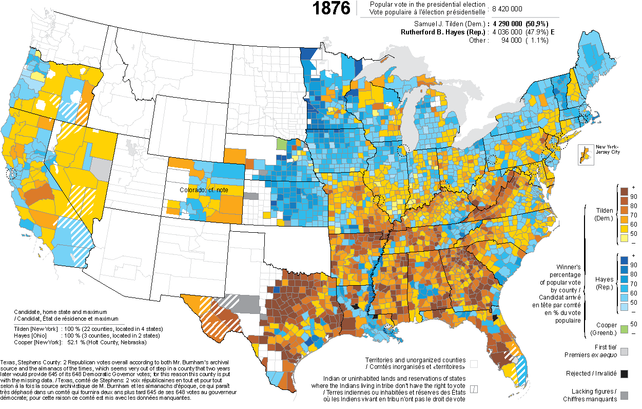
Wayne County is one of the most staunchly Republican leaning counties in Tennessee as well as the country when it comes to presidential elections. In the 20th century, the county was an enclave of the Republican Party in Middle Tennessee, one of few outside Eastern Tennessee in a state that was up until recently Democratic. No Democratic presidential candidate has carried the county since Samuel J. Tilden in the controversial 1876 election.[13]
| Year | Republican | Democratic | Third parties |
|---|---|---|---|
| 2016 | 86.0% 5,036 | 12.2% 717 | 1.8% 104 |
| 2012 | 77.5% 4,253 | 21.2% 1,163 | 1.3% 70 |
| 2008 | 73.8% 4,076 | 24.5% 1,355 | 1.7% 96 |
| 2004 | 66.8% 3,999 | 32.6% 1,951 | 0.6% 34 |
| 2000 | 63.5% 3,370 | 35.0% 1,859 | 1.5% 77 |
| 1996 | 58.4% 2,715 | 33.9% 1,574 | 7.8% 361 |
| 1992 | 56.1% 2,955 | 35.5% 1,868 | 8.4% 443 |
| 1988 | 68.8% 3,405 | 30.6% 1,516 | 0.6% 30 |
| 1984 | 68.3% 3,332 | 31.4% 1,534 | 0.3% 13 |
| 1980 | 64.5% 3,418 | 30.8% 1,633 | 4.6% 246 |
| 1976 | 57.6% 2,597 | 41.9% 1,891 | 0.5% 23 |
| 1972 | 79.8% 2,898 | 18.5% 673 | 1.7% 61 |
| 1968 | 58.5% 2,417 | 12.3% 506 | 29.2% 1,208 |
| 1964 | 68.1% 2,510 | 31.9% 1,178 | |
| 1960 | 75.2% 2,912 | 24.0% 931 | 0.8% 29 |
| 1956 | 70.7% 2,557 | 28.9% 1,045 | 0.4% 16 |
| 1952 | 70.6% 2,439 | 29.2% 1,008 | 0.2% 6 |
| 1948 | 68.4% 1,957 | 28.7% 820 | 3.0% 85 |
| 1944 | 77.5% 2,185 | 22.3% 630 | 0.2% 5 |
| 1940 | 69.2% 2,486 | 30.6% 1,100 | 0.2% 6 |
| 1936 | 63.9% 1,304 | 35.9% 733 | 0.2% 4 |
| 1932 | 66.0% 1,082 | 33.1% 543 | 0.9% 14 |
| 1928 | 81.6% 1,756 | 17.8% 382 | 0.6% 13 |
| 1924 | 75.2% 1,398 | 24.1% 448 | 0.7% 12 |
| 1920 | 79.7% 2,617 | 19.9% 654 | 0.4% 13 |
| 1916 | 75.3% 1,626 | 23.9% 517 | 0.8% 17 |
| 1912 | 53.8% 971 | 24.1% 435 | 22.1% 399 |
On rare occasions, the county has voted for Democratic candidates for U.S. Senate and state governor. Al Gore carried Wayne County in his run for the U.S. Senate in 1984 and his 1990 reelection bid, though he never carried in either 1992 or 1996 as Bill Clinton's vice presidential running mate or his campaign for the presidency in 2000, in which he also lost his home state. Aside from Gore, Jim Sasser carried the county in his last successful reelection bid for the Senate in 1988, Ned McWherter carried it in his 1990 reelection bid for governor, and Phil Bredesen carried it in his 2006 gubernatorial reelection bid.[14]
Education
College
Public schools
- Wayne County Adult Education Center
- Frank Hughes School
- Waynesboro Elementary School
- Waynesboro Middle School
- Wayne County High School
- Wayne County Technology Center
- Collinwood High School
- Collinwood Middle School
- Collinwood Elementary School
Media
Radio
- AM 930 WWON Waynesboro, Tennessee
- FM 94.9 WMSR-FM Collinwood, Tennessee
- FM 106.5 WLVS-FM Clifton, Tennessee
- FM 89.9 W210BE Waynesboro, Tennessee
- FM 100.7 WWON-FM Waynesboro, Tennessee
Newspaper
- The Wayne County News
- Wayne County Now
Events
- Singing on the Farm – Cypress Inn
- Tour De Wayne Bicycle Ride
- Fireworks Show – Waynesboro
- Fourth of July in the Park – Waynesboro
- Wayne County History and Craft Fair – Waynesboro
- Old Timer's Day – Collinwood
- Horseshoe Riverbend Festival – Clifton
Communities
Cities
- Clifton
- Collinwood
- Iron City (mostly in Lawrence County)
- Waynesboro (county seat)
Unincorporated communities
- Ashland
- Beech Creek
- Bethlehem
- Cantrell Subdivision
- Clifton Junction
- Cromwell Crossroads
- Crossroads
- Cypress Inn
- Dogwood Heights
- Fairview
- Flat Gap
- Forrest Hills
- Geneva
- Highland (North)
- Highland (South)
- Holly Creek
- Holt
- Houston
- Leatherwood
- Little Hope
- Longview Subdivision
- Lower Holly Creek
- Lutts
- Martin's Mills
- McGlamery's Stand
- Moccasin
- Mooney
- Mount Hope
- Ovilla
- Piney Grove
- Ransom Stand
- Shawnette
- Southgate
- Stout
- Threet
- Topsy
- Upper Holly Creek
- Whitten's Stand
- Woodlawn
Notable individuals
- Lon A. Scott – member of the United States House of Representatives for the 8th congressional district of Tennessee
- Thetus W. Sims – politician and a member of the United States House of Representatives for the 8th congressional district of Tennessee
See also
References
- 1 2 3 4 Bob Rains, "Wayne County," Tennessee Encyclopedia of History and Culture. Retrieved: April 23, 2013.
- 1 2 "State & County QuickFacts". United States Census Bureau. Retrieved December 7, 2013.
- ↑ "Find a County". National Association of Counties. Retrieved 2011-06-07.
- ↑ "2010 Census Gazetteer Files". United States Census Bureau. August 22, 2012. Retrieved April 14, 2015.
- ↑ "Population and Housing Unit Estimates". Retrieved June 9, 2017.
- ↑ "U.S. Decennial Census". United States Census Bureau. Retrieved April 14, 2015.
- ↑ "Historical Census Browser". University of Virginia Library. Retrieved April 14, 2015.
- ↑ Forstall, Richard L., ed. (March 27, 1995). "Population of Counties by Decennial Census: 1900 to 1990". United States Census Bureau. Retrieved April 14, 2015.
- ↑ "Census 2000 PHC-T-4. Ranking Tables for Counties: 1990 and 2000" (PDF). United States Census Bureau. April 2, 2001. Retrieved April 14, 2015.
- ↑ Based on 2000 census data
- ↑ "American FactFinder". United States Census Bureau. Retrieved 2011-05-14.
- ↑ Wayne County, City-Data.com. Retrieved: April 23, 2013.
- ↑ Géographie Électorale; 1876 presidential election county map
- 1 2 Leip, David. "Dave Leip's Atlas of U.S. Presidential Elections". uselectionatlas.org. Retrieved March 13, 2018.
External links
| Wikimedia Commons has media related to Wayne County, Tennessee. |
- Official website
- Chamber of Commerce
- Wayne County News
- Wayne County at Curlie (based on DMOZ)
Places adjacent to Wayne County, Tennessee | ||||||||||
|---|---|---|---|---|---|---|---|---|---|---|
| ||||||||||
Municipalities and communities of Wayne County, Tennessee, United States | ||
|---|---|---|
| Cities | ||
| CDP | ||
| Unincorporated communities |
| |
| Footnotes | ‡This populated place also has portions in an adjacent county or counties | |
