Polk County, Tennessee
| Polk County, Tennessee | |
|---|---|
 Polk County Courthouse in Benton | |
|
Location in the U.S. state of Tennessee | |
 Tennessee's location in the U.S. | |
| Founded | November 28, 1839 |
| Named for | James K. Polk[1] |
| Seat | Benton |
| Largest town | Benton |
| Area | |
| • Total | 442 sq mi (1,145 km2) |
| • Land | 435 sq mi (1,127 km2) |
| • Water | 7.7 sq mi (20 km2), 1.7% |
| Population | |
| • (2010) | 16,825 |
| • Density | 39/sq mi (15/km2) |
| Congressional district | 3rd |
| Time zone | Eastern: UTC−5/−4 |
| Website |
www |
Polk County is a county located in the southeastern corner of the U.S. state of Tennessee. As of the 2016 census estimate, the population was 16,773.[2] Its county seat is Benton.[3] The county was created on November 28, 1839, from parts of Bradley and McMinn counties. The county was named after then-governor (and future president) James K. Polk.
Polk County is included in the Cleveland, Tennessee, metropolitan statistical area, which is also included in the Chattanooga-Cleveland-Dalton, TN-GA-AL Combined Statistical Area.
Geography
According to the U.S. Census Bureau, the county has a total area of 442 square miles (1,140 km2), of which 435 square miles (1,130 km2) is land and 7.7 square miles (20 km2) (1.7%) is water.[4] The total area is 1.65% water. Located in the extreme southeastern corner of Tennessee, it is the state's only county to share borders with both Georgia and North Carolina.
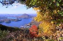
Much of the terrain of eastern Polk County is mountainous, including Big Frog Mountain, constituting part of the southern Appalachian Mountains. Large tracts of Polk County are part of the Cherokee National Forest. The Ocoee River, site of whitewater slalom events in the Atlanta 1996 Summer Olympic Games, runs through Polk County and is vital to one of the county's major industries, whitewater rafting. The calmer Hiwassee River, a tributary of the Tennessee River which flows through northern Polk County, is also used for rafting and tubing.
Adjacent counties
- Monroe County (northeast)
- Cherokee County, North Carolina (east)
- Fannin County, Georgia (southeast)
- Murray County, Georgia (southwest)
- Bradley County (west)
- McMinn County (northwest)
National protected areas
- Big Frog Wilderness (part)
- Cherokee National Forest (part)
State protected areas
- William L. Davenport Refuge
- Ducktown Basin Museum and Burra Burra Mine (state historic site)
- Fourth Fractional Township Wildlife Management Area
- Hiwassee/Ocoee Scenic River State Park
Demographics
| Historical population | |||
|---|---|---|---|
| Census | Pop. | %± | |
| 1840 | 3,570 | — | |
| 1850 | 6,338 | 77.5% | |
| 1860 | 8,726 | 37.7% | |
| 1870 | 7,369 | −15.6% | |
| 1880 | 7,269 | −1.4% | |
| 1890 | 8,361 | 15.0% | |
| 1900 | 11,357 | 35.8% | |
| 1910 | 14,116 | 24.3% | |
| 1920 | 14,243 | 0.9% | |
| 1930 | 15,686 | 10.1% | |
| 1940 | 15,473 | −1.4% | |
| 1950 | 14,074 | −9.0% | |
| 1960 | 12,160 | −13.6% | |
| 1970 | 11,669 | −4.0% | |
| 1980 | 13,602 | 16.6% | |
| 1990 | 13,643 | 0.3% | |
| 2000 | 16,050 | 17.6% | |
| 2010 | 16,825 | 4.8% | |
| Est. 2016 | 16,772 | [5] | −0.3% |
| U.S. Decennial Census[6] 1790-1960[7] 1900-1990[8] 1990-2000[9] 2010-2014[2] | |||
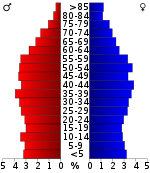
As of the census[11] of 2010, there were 16,825 people, 6,653 households, and 4,755 families residing in the county. The population density was 38.7 people per square mile. There were 7,991 housing units at an average density of 18.4 per square mile.
There were 6,653 households out of which 26.10% had children under the age of 18 living with them, 56.60% were married couples living together, 9.00% had a female householder with no husband present, and 26.30% were non-families. 25.0% of all households were made up of individuals and 11.20% had someone living alone who was 65 years of age or older. The average household size was 2.49 and the average family size was 2.96.
In the county, the population was spread out with 22.14% under the age of 18, 5.0% from 20 to 24, 10.20% from 25 to 34, 21.60% from 35 to 49, 21.70% from 50-64, and 17.10% who were 65 years of age or older. The median age was 42.5 years.
The racial origins of the county is White alone being 97.5%, Black or African American alone, 0.3%, American Indian and Alaska Native alone, 0.4%, Asian alone, 0.1%, Two or More Races, 1.3%, and Some Other Race being 0.04%. Hispanic or Latino origin being 1.3% of the population.
In 2000, the median income for a household in the county was $29,643, and the median income for a family was $36,370. Males had a median income of $27,703 versus $21,010 for females. The per capita income for the county was $16,025. About 9.70% of families and 13.00% of the population were below the poverty line, including 13.80% of those under age 18 and 18.40% of those age 65 or over.
Education
Public schools in Polk County are operated by the Polk County Schools district. High Schools include Copper Basin High School and Polk County High School. The district has one middle schools, Chilhowee Middle. The district also has three elementary schools, Benton Elementary, South Polk Elementary and Copper Basin Elementary.[12]
Benton fireworks disaster
On May 27, 1983, a massive explosion at an illegal fireworks factory exploded, killing eleven workers. The operation, located on a bait farm a few miles south of Benton, was unlicensed, and produced M-80 and M-100 fireworks, both illegal in Tennessee, and was the largest illegal fireworks operation in the United States to date.[13]
Communities
Cities
Town
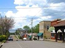
- Benton (county seat)
Unincorporated Communities
- Cherokee Hills
- Coalhill
- Conasauga
- Delano
- Dogtown
- Farner
- Harbuck
- Isabella
- Ocoee
- Oldfort
- Parksville
- Postelle
- Reliance
- Turtletown
Ghost Towns[14]
- Probst
- Bonnie
- McFarland
- Sylco
- Hidgon's Store
- Alaculsy
- Old Dutch Settlement
- Broad Shoals
- Smith Creek Village
- Apalachia
- Apalachia Station
- Caney Creek
- McHarge
Politics
| Year | Republican | Democratic | Third Parties |
|---|---|---|---|
| 2016 | 78.2% 5,097 | 19.2% 1,252 | 2.6% 171 |
| 2012 | 67.8% 4,108 | 30.6% 1,856 | 1.6% 95 |
| 2008 | 65.6% 4,267 | 32.7% 2,124 | 1.7% 110 |
| 2004 | 58.6% 3,924 | 40.7% 2,724 | 0.8% 52 |
| 2000 | 52.0% 2,907 | 46.0% 2,574 | 2.0% 113 |
| 1996 | 40.0% 1,910 | 51.4% 2,450 | 8.6% 410 |
| 1992 | 34.4% 1,584 | 56.0% 2,583 | 9.6% 443 |
| 1988 | 52.3% 2,297 | 47.2% 2,073 | 0.5% 21 |
| 1984 | 56.2% 2,785 | 42.6% 2,112 | 1.3% 63 |
| 1980 | 48.7% 2,414 | 49.8% 2,470 | 1.5% 76 |
| 1976 | 35.6% 1,835 | 63.7% 3,284 | 0.7% 36 |
| 1972 | 60.6% 2,285 | 37.9% 1,431 | 1.5% 56 |
| 1968 | 45.0% 1,808 | 36.2% 1,454 | 18.8% 754 |
| 1964 | 44.4% 1,685 | 55.6% 2,113 | |
| 1960 | 58.3% 2,187 | 40.8% 1,532 | 0.9% 32 |
| 1956 | 58.2% 2,136 | 41.8% 1,533 | |
| 1952 | 55.6% 2,283 | 44.4% 1,821 | |
| 1948 | 51.1% 1,529 | 47.2% 1,412 | 1.6% 49 |
| 1944 | 7.2% 378 | 92.7% 4,842 | 0.1% 6 |
| 1940 | 13.5% 562 | 86.5% 3,611 | |
| 1936 | 43.2% 1,755 | 56.2% 2,283 | 0.6% 24 |
| 1932 | 39.3% 1,642 | 60.7% 2,540 | |
| 1928 | 63.2% 1,760 | 36.4% 1,012 | 0.4% 12 |
| 1924 | 51.3% 1,247 | 47.3% 1,150 | 1.4% 34 |
| 1920 | 56.2% 1,018 | 42.8% 775 | 1.0% 18 |
| 1916 | 53.1% 887 | 45.9% 767 | 1.0% 17 |
| 1912 | 26.2% 533 | 42.7% 867 | 31.1% 631 |
Transportation
See also
References
- ↑ Marian Bailey Presswood, "Polk County," Tennessee Encyclopedia of History and Culture. Retrieved: 19 March 2013.
- 1 2 "State & County QuickFacts". United States Census Bureau. Retrieved December 7, 2013.
- ↑ "Find a County". National Association of Counties. Retrieved 2011-06-07.
- ↑ "2010 Census Gazetteer Files". United States Census Bureau. August 22, 2012. Retrieved April 9, 2015.
- ↑ "Population and Housing Unit Estimates". Retrieved June 9, 2017.
- ↑ "U.S. Decennial Census". United States Census Bureau. Retrieved April 9, 2015.
- ↑ "Historical Census Browser". University of Virginia Library. Retrieved April 9, 2015.
- ↑ Forstall, Richard L., ed. (March 27, 1995). "Population of Counties by Decennial Census: 1900 to 1990". United States Census Bureau. Retrieved April 9, 2015.
- ↑ "Census 2000 PHC-T-4. Ranking Tables for Counties: 1990 and 2000" (PDF). United States Census Bureau. April 2, 2001. Retrieved April 9, 2015.
- ↑ Based on 2010 census data
- ↑ "American FactFinder". United States Census Bureau. Retrieved 2018-07-07.
- ↑ "POLK CO SCHOOLS". polk-schools.businesscatalyst.com. Polk County Board of Education. Retrieved 7 July 2018.
- ↑ Jefferson, Jon; Bass, William (September 4, 2007). Beyond The Body Farm: A Legendary Bone Detective Explores Murders, Mysteries, and the Revolution in Forensic Science. Harper Collins. p. 67-86. ISBN 0060875283.
- ↑ "hiwassee river forum - Anyone know what this is?". hiwassee.net. Archived from the original on 2 February 2017. Retrieved 29 January 2017.
- ↑ Leip, David. "Dave Leip's Atlas of U.S. Presidential Elections". uselectionatlas.org. Retrieved 2018-03-12.
External links
| Wikimedia Commons has media related to Polk County, Tennessee. |
- Official site
- Polk County/Copper Basin Chamber of Commerce
- Polk County, TNGenWeb - free genealogy resources for the county
- Polk County at Curlie (based on DMOZ)
Places adjacent to Polk County, Tennessee | |
|---|---|
Municipalities and communities of Polk County, Tennessee, United States | ||
|---|---|---|
| Cities | ||
| Town | ||
| Unincorporated communities | ||
