Flintville, Tennessee
| Flintville, Tennessee | |
|---|---|
| Census-designated place | |
 Flintville Post office | |
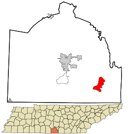 Location in Lincoln County and the state of Tennessee. | |
| Coordinates: 35°03′45″N 86°25′11″W / 35.06250°N 86.41972°WCoordinates: 35°03′45″N 86°25′11″W / 35.06250°N 86.41972°W | |
| Country | United States |
| State | Tennessee |
| County | Lincoln |
| Area[1] | |
| • Total | 5.323 sq mi (13.79 km2) |
| • Land | 5.323 sq mi (13.79 km2) |
| • Water | 0 sq mi (0 km2) |
| Elevation | 902 ft (275 m) |
| Population (2010)[2] | |
| • Total | 627 |
| • Density | 120/sq mi (45/km2) |
| Time zone | UTC-6 (Central (CST)) |
| • Summer (DST) | UTC-5 (CDT) |
| ZIP code | 37335 |
| Area code(s) | 931 |
| GNIS feature ID | 1284492[3] |
Flintville is an unincorporated community and census-designated place (CDP) in Lincoln County, Tennessee, United States. As of the 2010 census, its population was 627.[2] Flintville is located along Tennessee State Route 275 10.5 miles (16.9 km) southeast of Fayetteville.[4] Flintville has a post office with ZIP code 37335, which opened on February 16, 1861.[5][6]
References
- ↑ "US Gazetteer files: 2010, 2000, and 1990". United States Census Bureau. 2011-02-12. Retrieved 2011-04-23.
- 1 2 "American FactFinder". United States Census Bureau. Archived from the original on 2013-09-11. Retrieved 2011-05-14.
- ↑ "Flintville". Geographic Names Information System. United States Geological Survey.
- ↑ Lincoln County, Tennessee General Highway Map (PDF) (Map). Tennessee Department of Transportation. 2007. Retrieved December 10, 2012.
- ↑ United States Postal Service (2012). "USPS - Look Up a ZIP Code". Retrieved 2012-02-15.
- ↑ "Postmaster Finder - Post Offices by ZIP Code". United States Postal Service. Retrieved December 10, 2012.
Municipalities and communities of Lincoln County, Tennessee, United States | ||
|---|---|---|
| Cities | ||
| Town | ||
| CDPs | ||
| Unincorporated communities | ||
| Footnotes | ‡This populated place also has portions in an adjacent county or counties | |
This article is issued from
Wikipedia.
The text is licensed under Creative Commons - Attribution - Sharealike.
Additional terms may apply for the media files.