Franklin County, Tennessee
| Franklin County, Tennessee | |
|---|---|
 Franklin County Courthouse in Winchester | |
|
Location in the U.S. state of Tennessee | |
 Tennessee's location in the U.S. | |
| Founded | 1807 |
| Named for | Benjamin Franklin |
| Seat | Winchester |
| Largest city | Winchester |
| Area | |
| • Total | 576 sq mi (1,492 km2) |
| • Land | 555 sq mi (1,437 km2) |
| • Water | 21 sq mi (54 km2), 3.7% |
| Population | |
| • (2010) | 41,052 |
| • Density | 74/sq mi (29/km2) |
| Congressional district | 4th |
| Time zone | Central: UTC−6/−5 |
| Website |
franklincotn |
Franklin County is a county located in the U.S. state of Tennessee. As of the 2010 census, the population was 41,052.[1] Its county seat is Winchester.[2]
Franklin County is part of the Tullahoma-Manchester, TN Micropolitan Statistical Area.
History
Euro-American settlement began around 1800, and the county was formally organized in 1807 and named for Benjamin Franklin.[3][4] During the next several decades, the size of the county was reduced several times by reorganizations which created the neighboring counties of Coffee County, Moore County, and Grundy County. One of the most notable early settlers was frontiersman Davy Crockett, who came about 1812 but is not thought to have remained long.[3]
The University of the South, founded by the Episcopal Church, was organized just before the Civil War. It began full operations shortly after hostilities ceased. It encompasses a full university and theological seminary. The University of Tennessee Space Institute is also located in the county.
The area became strongly secessionist before the war. Franklin County formally threatened to secede from Tennessee and join Alabama if Tennessee did not leave the union, which it shortly did.[3] This contrasted sharply with the situation in nearby Winston County, Alabama, which was pro-Union and discussed seceding from Alabama. The two illustrate the often divided and confused state of loyalties in the central South during this period.
During 1863, the Army of Tennessee retreated through the county, leaving it to Union control thereafter. Isham G. Harris, Confederate governor of Tennessee, was from Franklin County. After being restored to political rights after the war, he was elected to represent the state in the United States Senate.
During the temperance (anti-liquor) agitations of the late 19th century, residents discovered that by a quirk of state law, liquor could be sold only in incorporated towns. As a consequence, all of the county's towns abolished their charters in order to prohibit liquor sales.[3]
In the 20th century, Franklin County benefited from the flood control and power generation activities of the Tennessee Valley Authority (TVA), built by the President Franklin D. Roosevelt administration during the Great Depression. The TVA helped bring new industry to the area. It also created opportunities for water recreation by making new lakes, but many county residents were displaced from their homes in the massive public works project. The establishment of the federal Arnold Engineering Development Center, which lies partly in the county, also helped spur economic growth and technical development. Although the interstate highway system barely touched the county, it did provide valuable access via Interstate 24 to nearby Chattanooga.
Two notable figures who were born in the county early in the twentieth century were singer/entertainer Dinah Shore and entrepreneur/philanthropist John Templeton. He later became a British subject and was awarded a knighthood.
During the last decades of the 19th and the first of the 20th, Tennessee, like other southern states, passed laws and constitutional amendments establishing Jim Crow: racial segregation in public facilities, restrictions of voting for blacks, and similar measures. There were few violent disturbances compared to many localities, but it was not until the mid-1960s, a decade after the historic Brown v. Board of Education court decision, that the county's schools were desegregated in 1964 after a lawsuit was won in Sewanee, Tennessee.
Considerable industrial growth occurred in the county in the last decades of the 20th century, including the construction of a large automobile engine plant by the Nissan corporation in Decherd. An emphasis on tourism also developed, based on Civil War history and local scenic attractions such as the dogwood forests, for which an annual festival is held.
Geography

According to the U.S. Census Bureau, the county has a total area of 576 square miles (1,490 km2), of which 555 square miles (1,440 km2) is land and 21 square miles (54 km2) (3.7%) is water.[5]
Franklin is one of Tennessee's southern tier of counties and abuts the Alabama border. It has a varied geography, extending from the southeast corner of the Nashville Basin over the Highland Rim and up onto the Cumberland Plateau, for a difference in elevation of about 1,300 feet (400 m). The county is well watered and forested, and except for the steeper areas of the plateau is well suited for agriculture, having a long growing season and mild winters.
Sewanee Natural Bridge is a 25 feet (7.6 m) high natural sandstone arch with a span of 50 feet (15 m).
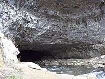
Lost Cove Cave, located near Sherwood, is in the Carter State Natural Area. One of its entrances is known as the Buggytop Cave Entrance and another entrance is known as the Peter Cave Entrance. The Buggytop Entrance is 100 feet (30 m) wide and 80 feet (24 m) high and opens at the base of an overhanging bluff 150 feet (46 m) high. The cave stream cascades down from the mouth and drops 40 feet (12 m) in less than 100 yards (91 m).[6]
Adjacent counties
- Coffee County (north)
- Grundy County (northeast)
- Marion County (east)
- Jackson County, Alabama (south)
- Madison County, Alabama (southwest)
- Lincoln County (west)
- Moore County (northwest)
State protected areas
- Bear Hollow Wildlife Management Area
- Carter State Natural Area
- Franklin State Forest (part)
- Hawkins Cove State Natural Area
- Mingo Swamp Wildlife Management Area
- Natural Bridge State Natural Area
- Owl Hollow Mill Wildlife Management Area
- South Cumberland State Park (part)
- Tims Ford State Park
- Walls of Jericho State Natural Area
Other protected areas
Demographics
| Historical population | |||
|---|---|---|---|
| Census | Pop. | %± | |
| 1810 | 5,730 | — | |
| 1820 | 16,571 | 189.2% | |
| 1830 | 15,620 | −5.7% | |
| 1840 | 12,033 | −23.0% | |
| 1850 | 13,768 | 14.4% | |
| 1860 | 13,848 | 0.6% | |
| 1870 | 14,970 | 8.1% | |
| 1880 | 17,178 | 14.7% | |
| 1890 | 18,929 | 10.2% | |
| 1900 | 20,392 | 7.7% | |
| 1910 | 20,491 | 0.5% | |
| 1920 | 20,641 | 0.7% | |
| 1930 | 21,796 | 5.6% | |
| 1940 | 23,892 | 9.6% | |
| 1950 | 25,431 | 6.4% | |
| 1960 | 25,528 | 0.4% | |
| 1970 | 27,244 | 6.7% | |
| 1980 | 31,983 | 17.4% | |
| 1990 | 34,725 | 8.6% | |
| 2000 | 39,270 | 13.1% | |
| 2010 | 41,052 | 4.5% | |
| Est. 2016 | 41,700 | [7] | 1.6% |
| U.S. Decennial Census[8] 1790-1960[9] 1900-1990[10] 1990-2000[11] 2010-2014[1] | |||
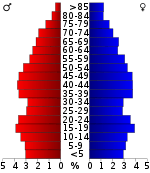
As of the census[13] of 2000, there were 39,270 people, 15,003 households, and 11,162 families residing in the county. The population density was 71 inhabitants per square mile (27/km2).
There were 16,813 housing units at an average density of 30 per square mile (12/km2). The racial makeup of the county was 92.20% White or European American, 5.49% Black or African American, 0.20% Native American, 0.41% Asian, 0.03% Pacific Islander, 0.60% from other races, and 1.06% from two or more races. 1.58% of the population were Hispanic or Latino of any race.
In the county, the population was spread out with 23.00% under the age of 18, 10.90% from 18 to 24, 26.40% from 25 to 44, 24.40% from 45 to 64, and 15.20% who were 65 years of age or older. The median age was 38 years. For every 100 females, there were 94.80 males. For every 100 females age 18 and over, there were 92.80 males.
The median income for a household in the county was $36,044, and the median income for a family was $42,279. Males had a median income of $31,506 versus $21,479 for females. The per capita income for the county was $17,987. About 9.60% of families and 13.20% of the population were below the poverty line, including 17.00% of those under age 18 and 13.00% of those age 65 or over.
Communities
Cities
- Cowan
- Decherd
- Tullahoma (partial)
- Winchester (county seat)
Towns
- Estill Springs
- Huntland
- Monteagle (also in Marion and Grundy Counties)
Census-designated place
Unincorporated communities
Notable people
- Stephen Adams (1807–1857), United States Senator and Representative[14]
- James Patton Anderson, (1822–1873), born in Franklin County, Confederate Army general [14]
- Jimmy Bedford (1940–2009), sixth master distiller at Jack Daniel's.[15]
- Phillip Fulmer (b. 1950), former head coach of the Tennessee Volunteers football team
- Bernie Moore (1895–1967), commissioner of the Southeastern Conference
- Dinah Shore (1916–1994), singer, actress, and television celebrity
- John Templeton (1912–2008), investor and philanthropist
Politics
| Year | Republican | Democratic | Third Parties |
|---|---|---|---|
| 2016 | 70.3% 11,532 | 26.7% 4,374 | 3.0% 498 |
| 2012 | 63.7% 10,262 | 34.8% 5,603 | 1.6% 254 |
| 2008 | 60.5% 10,539 | 37.9% 6,613 | 1.6% 280 |
| 2004 | 53.5% 9,129 | 45.7% 7,800 | 0.9% 148 |
| 2000 | 44.7% 6,560 | 53.3% 7,828 | 2.1% 303 |
| 1996 | 39.6% 5,296 | 51.8% 6,929 | 8.6% 1,154 |
| 1992 | 31.8% 4,507 | 54.8% 7,773 | 13.4% 1,896 |
| 1988 | 49.4% 5,381 | 50.0% 5,442 | 0.6% 63 |
| 1984 | 49.1% 5,705 | 50.3% 5,846 | 0.6% 70 |
| 1980 | 36.0% 3,995 | 61.0% 6,760 | 3.0% 335 |
| 1976 | 27.5% 2,619 | 71.3% 6,788 | 1.2% 117 |
| 1972 | 57.5% 4,136 | 40.3% 2,896 | 2.2% 160 |
| 1968 | 18.6% 1,700 | 27.3% 2,489 | 54.1% 4,939 |
| 1964 | 27.3% 2,262 | 72.7% 6,029 | |
| 1960 | 28.6% 2,041 | 70.6% 5,041 | 0.8% 57 |
| 1956 | 26.2% 1,727 | 72.7% 4,791 | 1.2% 77 |
| 1952 | 29.5% 2,015 | 70.0% 4,786 | 0.5% 33 |
| 1948 | 13.2% 589 | 66.1% 2,948 | 20.7% 924 |
| 1944 | 13.1% 600 | 86.6% 3,958 | 0.3% 15 |
| 1940 | 11.6% 569 | 88.1% 4,312 | 0.3% 12 |
| 1936 | 12.8% 519 | 86.9% 3,534 | 0.3% 13 |
| 1932 | 10.5% 360 | 88.7% 3,029 | 0.8% 28 |
| 1928 | 35.3% 928 | 64.5% 1,698 | 0.2% 6 |
| 1924 | 24.9% 707 | 73.0% 2,072 | 2.0% 58 |
| 1920 | 30.8% 1,558 | 69.2% 3,504 | 0.0% 2 |
| 1916 | 22.0% 711 | 76.3% 2,469 | 1.7% 55 |
| 1912 | 13.5% 370 | 79.3% 2,172 | 7.2% 196 |
See also
References
- 1 2 "State & County QuickFacts". United States Census Bureau. Archived from the original on July 10, 2011. Retrieved November 29, 2013.
- ↑ "Find a County". National Association of Counties. Archived from the original on May 31, 2011. Retrieved 2011-06-07.
- 1 2 3 4 John Abernathy Smith, "Franklin County," Tennessee Encyclopedia of History and Culture. Retrieved: 28 June 2013.
- ↑ Gannett, Henry (1905). The Origin of Certain Place Names in the United States. Govt. Print. Off. p. 131.
- ↑ "2010 Census Gazetteer Files". United States Census Bureau. August 22, 2012. Retrieved April 4, 2015.
- ↑ Barr, Thomas C. (1961). Caves of Tennessee. Bulletin 64 of the Tennessee Division of Geology. pp. 195–197.
- ↑ "Population and Housing Unit Estimates". Retrieved June 9, 2017.
- ↑ "U.S. Decennial Census". United States Census Bureau. Archived from the original on May 12, 2015. Retrieved April 4, 2015.
- ↑ "Historical Census Browser". University of Virginia Library. Retrieved April 4, 2015.
- ↑ Forstall, Richard L., ed. (March 27, 1995). "Population of Counties by Decennial Census: 1900 to 1990". United States Census Bureau. Retrieved April 4, 2015.
- ↑ "Census 2000 PHC-T-4. Ranking Tables for Counties: 1990 and 2000" (PDF). United States Census Bureau. April 2, 2001. Retrieved April 4, 2015.
- ↑ Based on 2000 census data
- ↑ "American FactFinder". United States Census Bureau. Archived from the original on September 11, 2013. Retrieved 2011-05-14.
- 1 2 Who Was Who in America, Historical Volume, 1607–1896. Chicago: Marquis Who's Who. 1963.
- ↑ Hevesi, Dennis. "Jimmy Bedford, Guardian of Jack Daniel’s, Dies at 69", The New York Times, August 10, 2009. Accessed August 11, 2009.
- ↑ Leip, David. "Dave Leip's Atlas of U.S. Presidential Elections". uselectionatlas.org. Retrieved 2018-03-10.
External links
| Wikimedia Commons has media related to Franklin County, Tennessee. |
- Official site
- Franklin County Chamber of Commerce
- Franklin County Schools
- Franklin County, TNGenWeb – genealogy resources
- History of Franklin County, transcribed from Goodspeed's History of Tennessee (1886–1887)
- Franklin County Landforms
- Franklin County at Curlie (based on DMOZ)
Places adjacent to Franklin County, Tennessee | ||||||||||
|---|---|---|---|---|---|---|---|---|---|---|
| ||||||||||
Municipalities and communities of Franklin County, Tennessee, United States | ||
|---|---|---|
| Cities | ||
| Towns | ||
| CDP | ||
| Unincorporated communities | ||
| Ghost town | ||
| Footnotes | ‡This populated place also has portions in an adjacent county or counties | |
